by
by 
Storms today, severe heat by Sunday. Michigan weather says to brace for triple-digit heat index and renewed thunderstorm threats across the Lower and Upper Peninsula.
Thunderstorms return today, but all eyes turn to a dangerous heat wave set to sweep Michigan beginning Sunday.
DETROIT — Issued by the National Weather Service at 3:20 AM on June 19, 2025
Scattered Showers and Thunderstorms Sweep Across Michigan
Southeast Michigan, including the Tri-Cities and Thumb, woke up to widespread rain Thursday morning. A departing low-pressure system has left behind a swath of moisture. Light rain will persist through midday with isolated thunderstorms possible by late afternoon. Though severe weather is not expected, gusty winds up to 55 mph may result from isolated microbursts.
Meanwhile, Northern Lower Michigan saw a cold front push southeastward, shifting showers east of I-75. Drier air behind the front has brought clearing skies and breezy north winds, particularly along the Lake Huron shoreline.
In the Upper Peninsula, isolated to scattered storms are expected this afternoon and evening, with central regions—especially along the Wisconsin border—bearing the greatest risk. While widespread severe storms are not forecast, a marginal threat for strong winds or hail remains possible.
Friday Through Saturday: A Brief Break Before a Heat Surge

Conditions calm briefly Thursday night. However, both Lower and Upper Michigan are in for renewed storm chances by Friday afternoon. Forecast models show a mid-level jet and weak front bringing another round of thunderstorms, especially during the evening and overnight hours.
According to the Storm Prediction Center, the Upper Peninsula faces a Slight Risk (Level 2 of 5) for severe weather Friday night. If instability builds and cap inversion weakens, damaging winds could hit parts of Marquette, Ironwood, and Escanaba. Storm timing and severity remain uncertain, hinging on convective development over Minnesota and Wisconsin.
Northern Lower Michigan also faces a Marginal Risk, especially around Petoskey and Alpena, with a low-end chance of isolated damaging winds and small hail.
Southeast Michigan Forecast: From Wet to Oppressively Hot
Thursday’s widespread showers across the Tri-Cities and northern Thumb will fade by late afternoon. However, clearing skies and moisture advection will create instability heading into Friday. Additional showers and scattered storms are expected through Saturday morning before high pressure takes over.
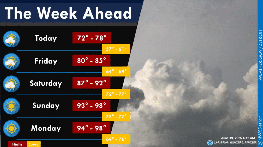
From Sunday into Monday, an aggressive upper-level ridge will dominate. Temperatures across Detroit, Flint, and Saginaw are expected to exceed 90°F, with heat index values between 98–104°F. Dew points in the 70s will add to the discomfort.
Overnight lows will offer little relief, staying in the low to mid 70s. Some urban areas may not dip below 76°F, heightening risk for heat-related health concerns.
Northern Lower and Upper Michigan Brace for Prolonged Heat
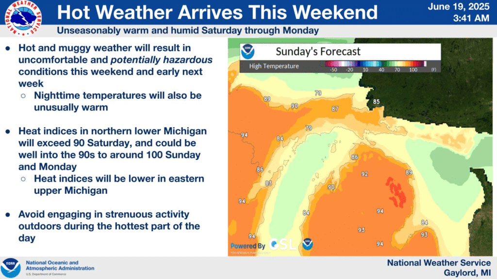
By Sunday, Traverse City, Gaylord, and the U.P. interior will also enter the heat wave. Forecast highs will climb into the upper 80s and low 90s, with heat index values potentially breaching 100°F.
The Upper Peninsula could see downsloping winds boost temperatures even higher. Areas like Ontonagon and Iron Mountain may reach 95°F, while persistent humidity keeps overnight lows in the upper 60s to mid-70s.
NBM and ECMWF model ensembles show unusually high agreement for such elevated temperatures. EPS EFI values (>.9) suggest this event could challenge all-time temperature records in some locations.
Marine Alerts in Effect for Parts of Lake Huron and Erie
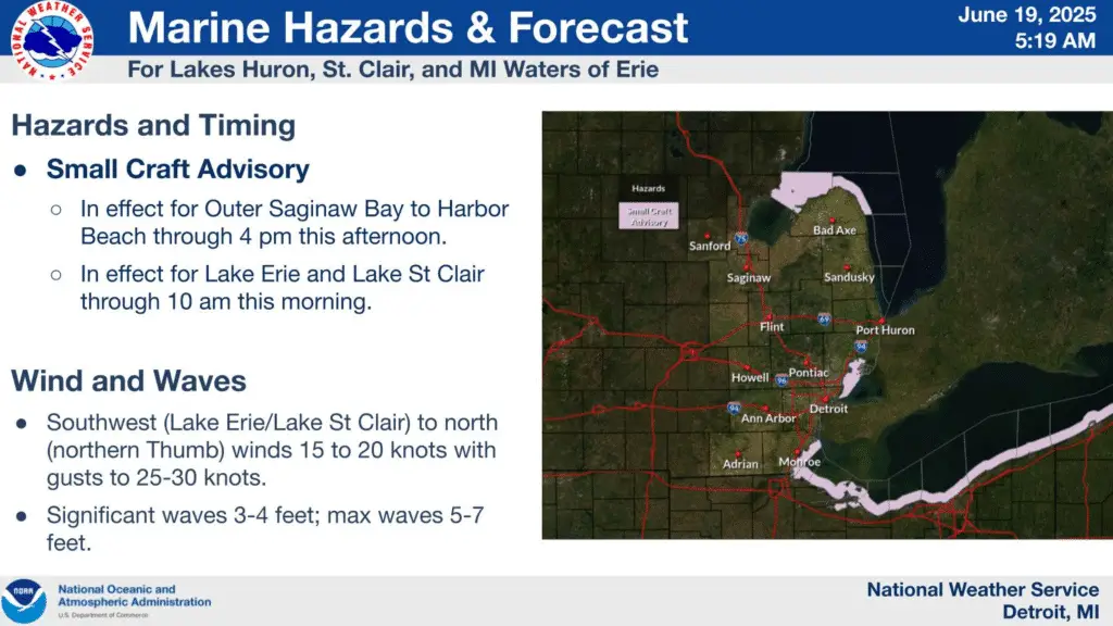
Small Craft Advisories are active Thursday across the following areas:
- Saginaw Bay to Harbor Beach
- Lake St. Clair
- Western Lake Erie
Winds behind the low-pressure system are expected to ease by late afternoon. However, boaters should anticipate choppy conditions and limited visibility in morning fog, particularly across northern Lake Superior.
Today’s Michigan Forecast Summary
- Southeast Michigan: Rain early, isolated storms late. High near 82°F.
- Northern Lower Michigan: Clearing skies, breezy. Highs in mid-70s.
- Upper Peninsula: Scattered storms. Highs range from upper 60s near Lake Superior to low 80s inland.
Hazardous Weather Changes Fast – Stay Updated
Weather Watches, Warnings, and Advisories are frequently updated by the NWS. Please look for updates to this report from the National Weather Service, your local news channels, and NOAA All Hazards radio.
Please follow ThumbWind Publications for more local weather and news updates. Your helpful comments are welcome.
More Weather Stories
14 Areas Around the Great Lakes With Significant Lake Effect Snow – How Does it Happen
A detailed review of key regions affected by lake-effect snow.
4 Live Venice Florida Webcams, Latest Venice News & Weather Updates
See real-time weather and traffic from the Gulf Coast of Florida.
Great Lakes Ice Coverage
View interactive maps and reports on Great Lakes ice trends from U.S. and Canadian sources.