by
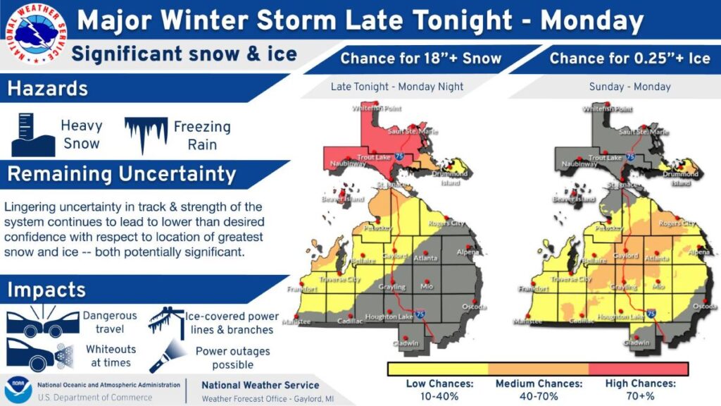
by Northern Michigan is preparing for a powerful late-season winter storm that could bring 1 to 3 feet of snow, ice accumulation, and wind gusts up to 60 mph, according to multiple warnings issued by the National Weather Service.
The storm is expected to impact large portions of the Upper Peninsula beginning early Sunday morning and lasting through Tuesday morning, potentially making travel nearly impossible and causing power outages.
The approaching storm also offers a reminder that severe winter weather has long been part of Michigan’s history. A newly released Michigan Moments video revisits some of the state’s most dramatic snowstorms from the early 1900s through the mid-20th century.
Winter Storm Warning Issued for Large Portions of Upper Michigan
The National Weather Service offices in Gaylord and Marquette issued Winter Storm Warnings covering much of the Upper Peninsula, including:
- Chippewa County
- Mackinac County
- Keweenaw Peninsula
- Ontonagon County
- Houghton County
- Marquette County
- Delta County
- Alger and Luce counties
- Dickinson, Iron, Gogebic and Menominee counties
Forecasters say the system will bring a mix of heavy snow, sleet, and freezing rain, with the greatest snow totals expected west of Interstate-75 in eastern Upper Michigan.
Snowfall totals could reach 1 to 3 feet, while ice accumulation near Drummond Island could approach one quarter inch.
Wind gusts between 45 and 60 mph are also possible, particularly along the Lake Superior shoreline and across the Keweenaw Peninsula.
Blizzard Conditions Possible

Meteorologists warn that the combination of heavy snow and strong winds could produce whiteout conditions, especially Sunday night into Monday.
Those conditions could make travel dangerous or impossible.
The National Weather Service stated that Monday morning and evening commutes may be heavily impacted, particularly in central and western Upper Michigan.
Falling tree branches and scattered power outages are also possible due to ice and wind.
Residents are being advised to delay travel if possible.
If travel is necessary, officials recommend carrying emergency supplies including:
- Flashlight
- Food
- Water
- Extra clothing or blankets
Michigan’s Long History of Powerful Snowstorms
The incoming storm is far from unusual in a state known for intense winter weather.
Michigan’s geography between three Great Lakes creates ideal conditions for lake-effect snow and powerful winter systems.
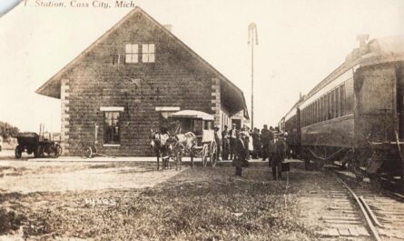
Historical photographs show communities across the state buried under towering snowbanks during major storms in the early 20th century.
One of the most notable events occurred during the Great Michigan Blizzard of February 1912, when snowdrifts shut down travel and railroads across much of the state.
Other storms documented in historic images include:
- Early and late season snowfalls in 1906 and 1907
- Major drifts in Three Rivers, Battle Creek, and Saginaw in 1912
- Lake-effect snowstorms in Gaylord and Munising
- A damaging ice storm in Cadillac in 1922
These storms often occurred decades before modern snow removal equipment or advanced weather forecasting.
Historic Images Featured in New Michigan Moments Video
The newly released Michigan Moments episode presents a montage of rare historical photographs showing how Michigan communities coped with severe winter weather between 1900 and 1950.
The video includes scenes from towns across the state, including:
- Rockland
- Alpena
- Mancelona
- Shelby
- Saginaw
- Munising
- Muskegon
The images document massive snowbanks, buried rail lines, and streets carved through drifts by residents working to reopen their towns.
While technology has improved winter preparedness, storms like the one forecast this weekend demonstrate that Michigan winters can still be powerful and disruptive.
Storm Arrives Sunday
The National Weather Service says conditions will begin deteriorating early Sunday morning, with the worst impacts likely Sunday night through Monday.
Warnings remain in effect through early Tuesday morning for several regions.
Officials continue to urge residents to monitor forecasts and prepare for possible travel disruptions and power outages.