by
by 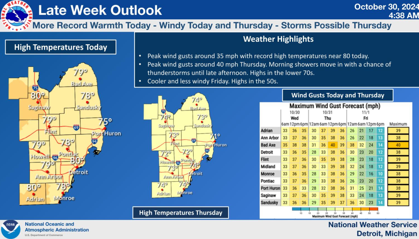
Unseasonably warm weather strikes Southeast Michigan, bringing wind gusts up to 45 MPH and thunderstorms as temperatures flirt with record highs today and tomorrow.
Warm Winds and Possible Thunderstorms Forecast to Rock Southeast Michigan
[DETROIT] — Issued by the National Weather Service at 6:57 AM on October 30, 2024.
High Temperatures, Wind Gusts, and Cold Front to Bring Weather Swings
Southeast Michigan is experiencing an unusual late October heatwave, with temperatures soaring to nearly 80 degrees today. Forecasts from the National Weather Service (NWS) warn of powerful southwest wind gusts ranging between 30 to 40 MPH today, increasing to 45 MPH on Thursday afternoon. A cold front following these warm conditions could trigger showers and a few elevated thunderstorms by Thursday evening, with cooler temperatures trailing behind.
Weather experts expect today’s high temperatures to challenge historical records, including Detroit’s standing 76-degree record from 1999. Low temperatures are also remarkably high, with some cities already flirting with record minimum temperatures this morning.
Breezy Days Ahead: Record Warmth Before Temperatures Plunge
Warm winds from a high-pressure system in the Mid-Atlantic are responsible for today’s elevated temperatures. Forecasters are warning residents that gusty winds will persist throughout the day and into Thursday, potentially leading to a Wind Advisory.
A strong cold front will sweep through the region on Thursday, bringing the possibility of isolated thunderstorms. While severe storms are unlikely, strong downdrafts could drive surface winds above 45 MPH, particularly near the Tri-Cities and Thumb regions.
Saginaw and Lake Huron Areas Brace for Gale Winds
The cooler air arriving behind the cold front could result in near-gale-force winds Thursday night through Friday morning. A Gale Watch is already in effect for Lake Huron, and Small Craft Advisories remain in place across inland waters, including Lake St. Clair and Lake Erie. Mariners are advised to exercise caution as waves may rise beyond 4 feet.
Hazardous Weather Changes Fast – Stay Updated
Weather Watches, Warnings, and Advisories are frequently updated by the National Weather Service. Please monitor this report, tune into local news channels, or listen to NOAA All Hazards radio for timely updates.
For additional local weather coverage, visit ThumbWind Publications.
Check Out Our Weather Related Features
- Climate Twins – Countries with Weather Similar to Michigan
Curious about which places on Earth share Michigan’s unique weather patterns? Our latest article dives into Michigan’s Climate Twins, revealing surprising similarities and intriguing differences. - Live Webcams Of 7 Lake Effect Snow Cities Around The Great Lakes
Delve into the enchanting world of Lake Effect Snow in cities within the snow belt. Experience how urban landscapes transform into winter wonderlands with heavy snowfall. - 14 Areas Around the Great Lakes With Significant Lake Effect Snow – How Does it Happen
Learn how Lake Effect Snow occurs when cold air currents mix with evaporating water from open Great Lakes. Discover the science behind winter storms and snowfall patterns.
Your Turn – Like This, or Hate It – We Want To Hear From You
Please offer an insightful and thoughtful comment. Idiotic, profane, or threatening comments are eliminated without remorse. Consider sharing this story. Follow us to have other feature stories fill up your Newsbreak feed from ThumbWind Publications.