by
by 
Lake Effect Snow Cities: We will explore how Lake Effect Snow blankets various cities within the snow belt, turning them into urban winter wonderlands. From the Great Lakes to your screen, witness the captivating transformation brought by the lakes dumping a boatload of snow on urban areas, big and small.
Table of Contents
Lake Effect Snow and the Great Lakes: A Winter Wonderland
The snow belt, stretching along the Great Lakes, is a region where heavy snowfall is a norm, thanks to lake-effect snow. This natural phenomenon turns the area into a picturesque winter haven, appealing to both locals and travelers alike.
What is Lake Effect Snow?
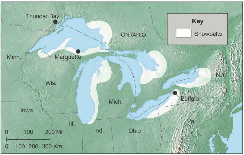
Lake-effect snow is a fascinating meteorological phenomenon predominantly affecting the Great Lakes region, where cold air masses move over warmer lake waters. As the frigid air passes over the unfrozen and relatively warm lakes, moisture is picked up, creating clouds that eventually lead to snowfall. This process is especially pronounced when the prevailing winds align, directing these moisture-laden clouds over the land. The result is significant snowfall, often in narrow bands, that can create picturesque winter landscapes but also challenging weather conditions.
The Great Lakes act as giant cauldrons, brewing up some of the most unique and intense snowfalls seen anywhere in the United States. This distinct characteristic not only shapes the climate and natural beauty of the surrounding areas but also deeply influences the lifestyle and activities of the people living in the snow belt regions.
Where are the Top Lake Effect Snow Cities Around The Great Lakes
Webcams are now installed in key Snow Belt cities around the Great Lakes. These cameras provide real-time updates on weather conditions. They aid in monitoring and predicting snowfall patterns. This advanced tool is beneficial for residents, tourists, and meteorologists. Consequently, they help in planning travel, managing road conditions, and enhancing climate studies (Great Lakes Webcams, 2021).
Traverse City
Traverse City: West Grand Traverse Bay
Traverse City’s significant lake effect snow is largely due to its proximity to Lake Michigan. In winter, cold air from the north travels over the warmer lake waters, absorbing moisture. This air then cools over land, resulting in heavy, localized snowfall. Lake Michigan’s size ensures a long journey for the air across the lake, gathering ample moisture. The specific orientation of the lake, aligned north-south, maximizes this effect, especially with prevailing westerly winds.
The region’s topography also plays a key role in enhancing snowfall in Traverse City. Hills and valleys around the area create an orographic lift, causing the moist air to rise and cool, leading to snow. Early in the winter, the stark temperature difference between the warmer lake and the cooler land intensifies this effect. As the season progresses, the lake cools, gradually reducing the intensity of the lake-effect snow. However, Traverse City’s location ensures it remains a primary recipient of this picturesque winter phenomenon.
Traverse City, Michigan, typically receives an average annual snowfall of about 80 to 100 inches (approximately 203 to 254 centimeters).
Wawa Ontario
Wawa Airport
Wawa, Ontario, experiences significant lake effect snow primarily due to its location near Lake Superior, one of the largest and northernmost of the Great Lakes. This area becomes a prime spot for snowfall when cold, arctic air moves over the relatively warmer waters of Lake Superior. As this air travels over the lake, it absorbs moisture, which then cools and condenses into snow when it reaches the land. Lake Superior’s vast expanse ensures a considerable amount of moisture is picked up, leading to heavy snowfall. Additionally, the lake’s orientation allows for a long fetch, whereby winds traveling over the lake enhance snow production as they reach Wawa.
The topography surrounding Wawa further intensifies the lake-effect snow. The area’s varied landscape, including elevated terrains, contributes to orographic lifting, where air is forced to rise and cool, producing more snow. Wawa’s geographical position exposes it to prevailing northwest winds, which are particularly effective in generating lake-effect snow. The temperature differential between the lake and the surrounding land during early winter is also a critical factor in the intensity of the snowfall. Despite Lake Superior beginning to cool later in the season, Wawa continues to experience substantial lake-effect snow, defining much of its winter climate.
Wawa, Ontario, known for its significant lake effect snow due to its proximity to Lake Superior, receives an average annual snowfall of approximately 135 inches (about 343 centimeters).
Marquette Michigan
Marquette, Michigan, is notably impacted by lake effect snow due to its position on the southern shore of Lake Superior. This location places it directly in the path of cold northern air masses that move across the relatively warmer waters of Lake Superior during the winter. As these cold winds travel over the lake, they pick up moisture, which is then dumped as snow when the air moves over the colder land. Lake Superior’s large surface area ensures a significant moisture accumulation, leading to substantial snowfall in Marquette. Furthermore, the lake’s elongated shape, aligned west to east, allows for a long over-water wind fetch, intensifying the lake-effect snow.
The topography of the area around Marquette also enhances the lake-effect snow conditions. The higher elevations inland cause the moisture-laden air to rise and cool, increasing snowfall through orographic lifting. Marquette’s geographical situation exposes it to prevailing winds from the northwest, which are most effective in producing lake-effect snow. The stark contrast in temperature between the warm lake and the cold land during the early winter months further escalates the intensity of the snowfall. As a result, Marquette experiences some of the heaviest lake-effect snowfalls in the Great Lakes region, defining its winter landscape.
Marquette, Michigan, receives approximately 149 inches of snowfall each year. This information is based on data from the National Weather Service (NWS) for the Marquette area.
Sebewaing Michigan
Sand Point North of Sebewaing
Sebewaing, located in Michigan’s Thumb region, experiences a significant impact from lake effect snow due to its location on Saginaw Bay and proximity to Lake Huron. The lake effect snow occurs when cold, dry air passes over the warmer waters of the lake. As the warm lake water evaporates, it rises into the cold air, creating clouds. When these clouds reach the shore, they release moisture as snowfall.
The city of Sebewaing is situated on the eastern shore of Saginaw Bay, making it particularly susceptible to this weather pattern. The prevailing westerly winds carry moisture-laden air from the lake directly into the region, causing heavy snowfall during the winter months.
Buffalo New York
Buffalo, New York, is well-known for its heavy lake effect snow, primarily due to its location near Lake Erie’s eastern end. During the winter, cold air masses from Canada and the Midwest pass over the warmer waters of Lake Erie. This process allows the air to pick up moisture from the lake, which is then released as snow when the air moves over the cooler land near Buffalo. Lake Erie’s relatively shallow waters warm up quickly in the summer and retain this warmth into the winter, providing a continuous moisture source. The lake’s orientation, stretching from southwest to northeast, aligns perfectly with the directions of common winter wind, facilitating the movement of moist air toward Buffalo.
The topography of the region around Buffalo also plays a significant role in the intensity of lake-effect snow. The area’s relatively flat landscape allows the moisture-laden air to travel uninterrupted until it reaches the city, where it begins to cool and deposit snow. Additionally, when the wind direction is just right, usually from the west or southwest, it maximizes the snowfall in Buffalo by transporting the maximum amount of moisture from the lake. The temperature difference between the lake and the land is most pronounced in the early winter, leading to more intense snowfall. Consequently, Buffalo experiences some of the most dramatic and persistent lake effect snow events in the United States, significantly impacting the region’s winter weather patterns.
Buffalo, New York, renowned for its lake effect snow, receives an average annual snowfall of about 95 inches (approximately 241 centimeters).
Tobermory Ontario on Bruce Penninsula
Northern Bruce Peninsula
Tobermory, Ontario, located at the tip of the Bruce Peninsula, experiences substantial lake effect snow due to its unique position between Lake Huron and Georgian Bay. This small town is affected by cold air masses that travel over the relatively warmer waters of these surrounding bodies of water during winter. As the cold air passes over the lakes, it picks up moisture, which is later transformed into snow when the air reaches the colder land over the peninsula. The narrow shape of the Bruce Peninsula means that Tobermory is often surrounded by these moisture-rich air currents, leading to frequent and heavy snowfalls. The area’s north-south orientation also aligns with prevailing winter wind patterns, further enhancing the snow accumulation.
The specific geography of Tobermory and its surrounding area also contributes to the intensity of lake-effect snow. Elevated areas on the peninsula encourage the rising and cooling of warm, moist air, resulting in increased snowfall – a process known as orographic lifting. The Bruce Peninsula acts like a natural barrier, trapping the moisture-laden air in the Tobermory region. Furthermore, the contrasting temperatures between the open water and the cold winter air over land make the lake effect snow particularly intense during the early and mid-winter months. As a result, Tobermory is known for its picturesque winter landscapes, heavily influenced by the unique weather patterns created by its location.
Tobermory, Ontario, located on the Bruce Peninsula between Lake Huron and Georgian Bay, receives moderate snowfall compared to other lake-effect snow-prone areas. On average, Tobermory gets approximately 40 to 60 inches (about 102 to 152 centimeters) of snow annually.
Rochester, New York
Charlotte: Genesee River Near Rochester, New York
Rochester, New York, is one of the well-known lake effect snow cities largely due to its proximity to Lake Ontario. During the winter months, cold air masses from the north and west move over the warmer waters of Lake Ontario. This interaction causes the air to pick up moisture from the lake, which then turns into snow when it reaches the cooler land around Rochester. The city’s location east of the lake is perfectly positioned to receive snow from prevailing westerly winds. Additionally, the relatively long fetch of Lake Ontario allows the air to gather more moisture, leading to heavier snowfall in Rochester.
The geography of the Rochester area also contributes to the amount of lake-effect snow it receives. Elevated regions south of the city can enhance snowfall through orographic lifting, where rising terrain causes the air to cool and release more snow. Rochester’s position on the southern shore of Lake Ontario makes it susceptible to varying wind directions, which can increase or decrease snowfall intensity. On average, Rochester receives about 100 inches (about 254 centimeters) of snow yearly. This significant snow is a defining feature of the city’s winter weather, impacting daily life and the local environment.
Final Thoughts About Lake Effect Snow Cities
The snow belt around the Great Lakes is unmatched winter beauty. Experience the beauty of Lake Effect Snow in cities as you journey through their snowy landscapes. Through these live webcams, we can all share the awe-inspiring sights that make this area special. Let us know where you’re at in the comments below.