 by
by 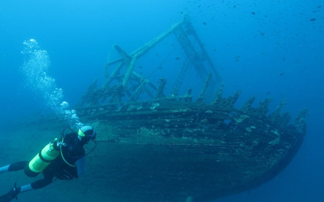
I was surprised to learn that there are an estimated 6,000 sunken ships across all the Great Lakes, with about 1,500 Michigan shipwrecks in local waters. With so many wrecks, it’s no wonder that in 1980, Michigan started establishing Underwater Preserve Sites. The last open water preserve created was the Thunder Bay National Marine Sanctuary and Underwater Preserve in 2000. This Lake Huron site is one of only 13 national marine sanctuaries in the United States by the National Oceanic and Atmospheric Administration (NOAA).
Michigan’s thirteen underwater preserves protect the shipwrecks on its Great Lakes bottomlands and ensure they remain for future generations to study and enjoy. It is against the law to bring up anything, object, or move anything without a permit.
Closer to home, there are two underwater preserves in Michigan’s Upper Thumb. The Sanilac Shores and Thumb Area Underwater Preserves.
Michigan ShipWreaks – Table of Contents
Lake Huron Shipwreck Maps
Lake Huron, one of the Great Lakes bordering Michigan, is home to a fascinating collection of shipwrecks that glimpse the region’s maritime history. From schooners lost during fierce storms to steamers that collided in foggy waters, the lake’s depths hold more than 1,000 wrecks waiting to be explored.
Sanilac Shores Underwater Preserve

The Sanilac Shores preserve hosts some of the most amazing Michigan shipwrecks on the Great Lakes. Of particular note is the wreck of the Regina. Sunk during the Great Storm of 1913. This 250-foot steel package freighter was discovered in 1986. The ship lays upside down in 80 feet of water and rises 25 feet from the bottom. Cargo is scattered on the bottom, with visibility typically ranging from 5 to 25 feet.
Sanilac Shores also is the resting spot for the wreck of the Sport, a 57-foot steel-hulled tugboat that sank in a gale in December 1920. In deeper waters, the debris of the schooner Checotah and steamer New York lie in 120 feet of water. According to local charter operators, diving to these ships should only be attempted by advanced divers. These vessels lie within a few hundred yards of each other in about 120 feet of water. Another deep dive is the Mary Alice B. This popular dive site is in 94 feet of water, with the ship lying upright and totally intact. Other vessels in the preserve include the North Star, Col. A. B. Williams, and Eliza H. Strong.
Thumb Area Underwater Preserve

The Thumb area underwater preserve offers wrecks and natural attractions in its 276 square miles of open water. Near Grindstone City marina lies the remains of large grindstones along the shore. The current high water of Lake Huron means that snorkelers and divers will be the only ones to see the last vestiges of the Upper Thumb’s primary industry. The tip of the Thumb has exposed limestone all along the shore. Those with a sense of adventure can carefully visit the caves near the reef’s edge near Port Austin Lighthouse.
Ten significant shipwrecks are in the Thumb Area Underwater Preserve in Lake Huron. These dangerous sholes and limestone reefs made many ships their victims as they turned into Saginaw Bay and Bay City. In his lecture during the Charity Island Dinner Cruise, historian Bob Wiltse indicated that the ship traffic during the lumbering area was similar to today’s highways.
Two of the Michigan shipwrecks sank due to a collision in 1893. The Philadelphia and Albany both rest in deep water in the preserve. Sitting at 130 feet, the steamer Philadelphia rests upright and surprisingly in one piece. Divers say that the 236-foot ship still has a cookstove resting on the deck.
The 267-foot steel steamer Albany is just southwest of Philadelphia at 150 feet of depth. The ship sank while under tow after the collision. Both ships are for advanced divers with vis at between 5 to 15 feet.
The Chickamauga is a famous dive for recreational divers. It sank in 1919. It is located only a while east of Harbor Beach at 35 feet. It’s a 322-foot, double-deck schooner. Other ships in the preserve include the Enterprise, Iron Chief, Dunderburg, Hunter Savidge, Glenorchy, and Governor Smith.
Thunder Bay National Marine Sanctuary and Underwater Preserve
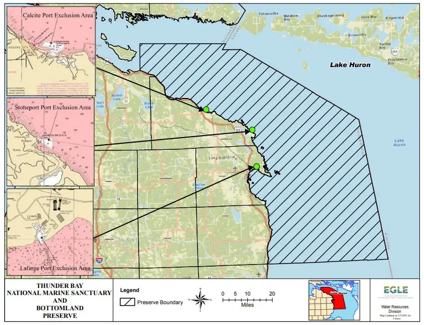
Designated in 2000 as part of NOAA’s National Marine Sanctuary program, the Thunder Bay National Marine Sanctuary and Underwater Preserve stands out as the first Great Lakes national marine sanctuary. Jointly managed by NOAA and the State of Michigan, it spans 4,300 square miles and focuses on protecting submerged cultural resources, advancing education, conducting research, and promoting recreation. Highlights include archaeological surveys, mooring buoys at wreck sites, and a maritime heritage center opened in 2005. Plans aim to connect classrooms to wreck sites via live video links.
The sanctuary offers exceptional diving experiences with numerous shipwrecks and natural attractions in and around Thunder Bay. Clear waters make it a prime spot for underwater photography, and shallow wrecks cater to both novice and experienced divers.
Among its most notable sites is the Nordmeer, a 550-foot German steamer that ran aground on Thunder Bay Shoal in 1966. At just 40 feet deep, it is ideal for beginners, featuring intact hull sections and large hatches that allow sunlight to illuminate the interior. Nearby, a steel barge provides additional exploration opportunities.
For intermediate divers, the Montana, a 235-foot steamer that sank in 1914, offers a fascinating dive at 70 feet. Its partially intact hull and scattered machinery are often surrounded by fish, making it a hotspot for underwater photographers. Another advanced site is the Grecian, a steamer that sank in 1906, with its remains lying at 75 feet.
Thunder Bay’s shallow wrecks and buoyed dive sites make it an accessible destination for divers of all skill levels. While shore diving is limited, local charter services provide excellent access to this underwater treasure trove.
De Tour Passage Bottomland Preserve
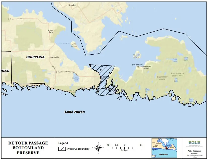
Located at the eastern tip of Michigan’s Upper Peninsula, the DeTour Passage Underwater Preserve spans the waters between the mainland and Drummond Island. This preserve offers a range of dive sites, many in shallow depths of less than 30 feet, making it an excellent choice for divers of all experience levels.
A standout wreck in the preserve is The General, a 97-foot tugboat that served the Great Lakes until it sank near Frying Pan Island in 1930. This site is a popular alternative when the weather makes other locations less accessible. Nearby, the partially exposed remains of the Sainte Marie, a converted rail car ferry, attract divers and surface explorers alike. Adjacent to it lies a steel side wheel from another vessel, while the wreck of the John W. Cullen can be found just east of these landmarks.
Beyond the preserve, several notable wrecks lie near Drummond Island. The John B. Merrill, a three-masted schooner that wrecked in 1893, rests at 65 feet. The J.C. Ford, a steamer that caught fire and exploded in 1924, lies in just 15 feet of water near Little Trout Island, offering good visibility of 10 to 15 feet.
For those seeking variety, dock ruins in the northern part of the preserve add a unique dive site to explore. Divers with their own boats can access the preserve via two launch ramps in the Village of DeTour, making this preserve a convenient and rewarding destination for underwater adventures.
Michigan Shipwrecks Interactive Map
The Michigan History Center has developed a very informative map containing all the shipwreck information in each of the 13 underwater preserves. You can zoom in on a particular area and drill down for more information on a specific wreck. Search for a shipwreck by name or location. You can also design and print off a PDF map. So you can create your own Lake Michigan shipwreck map or Lake Huron shipwreck map. How handy.
The Shipwrecks of Michigan map works excellently on smartphones or tablets, so it’s perfect when out in the field. You can discover Michigan shipwrecks to snorkel, kayak, paddle-board, and dive. It will also give GPS coordinates and indicate the experience level and depth for divers at Michigan shipwreck locations.
Video: Ghost Ships of the Great Lakes: Lost Beneath the Waves
FAQs About Michigan Shipwrecks and Underwater Preserves
What are Michigan’s Underwater Preserves, and why were they created?
Michigan’s 13 Underwater Preserves are designated areas within the Great Lakes that protect shipwrecks and other underwater features. Established to preserve these historical and cultural artifacts, the preserves ensure they remain intact for future generations to study and enjoy. It is illegal to disturb or remove any objects from these sites without a permit.
How can I locate and learn more about Michigan shipwrecks?
The Michigan History Center offers an Interactive Shipwreck Map that provides detailed information about shipwrecks within the 13 underwater preserves. Users can search by ship name or location, zoom in on specific areas, and even print customized maps for exploration. The map is mobile-friendly, making it an ideal tool for divers, snorkelers, and enthusiasts exploring Michigan’s shipwrecks.
Are all Michigan shipwrecks suitable for recreational diving?
No, not all Michigan shipwrecks are suitable for recreational diving. Many shallow wrecks, such as the Chickamauga in the Thumb Area Underwater Preserve, are accessible to recreational divers at depths of 35 feet. However, some shipwrecks, like the Philadelphia and Albany, rest in deeper waters (130–150 feet) and require advanced diving skills due to challenging conditions and limited visibility. Always check local dive guidelines and consult with charter operators before planning a dive.
Related Reading
Great Lakes ice coverage is hovering along a record low for this time in the winter season. At the same time, Lakes Michigan and Huron broke records for high water levels the last set 33 years ago. We are tracking both ice and water levels during what is expected to be a record-setting year.

It seems that each year, the art scene in Port Austin grows. We browse the Cove Gallery in Port Austin which is steps away from the Port Austin Farmers Market. Find out other galleries and studios to explore in the Upper Thumb.


I’m excited to see this. I’ll be following your “work in progress”. I’d love to have a map of these!
Try it out and let us know how it works.