 by
by 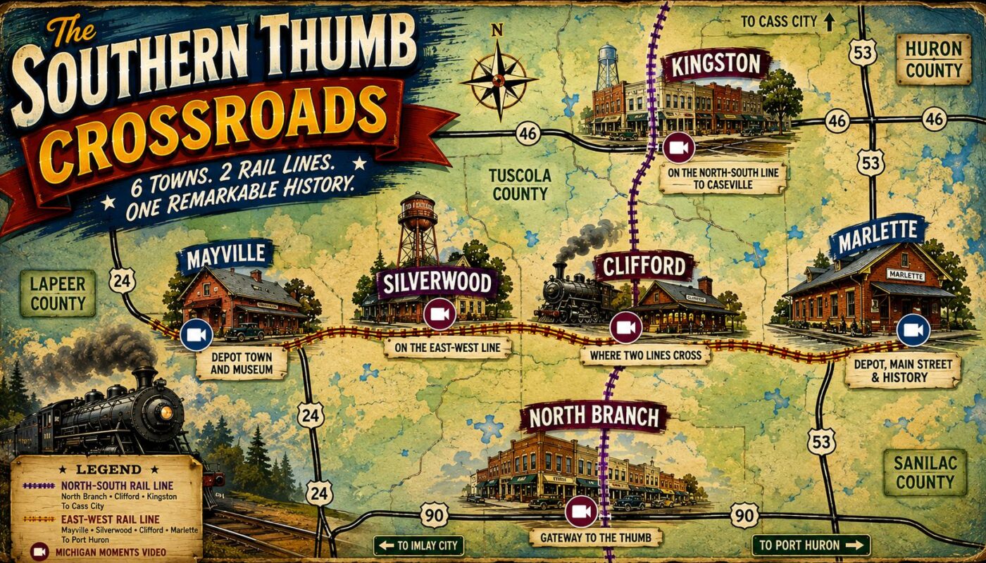
Six Michigan towns share one overlooked past shaped by intersecting railroads, lumber camps, farm markets, fires and the slow decline of passenger service.
Southern Thumb history does not fit neatly within a single county line.
Marlette, Clifford, North Branch, Mayville, Kingston and Silverwood sit across northern Lapeer County, southern Tuscola County and western Sanilac County. Each community has its own identity, but their early fortunes were closely connected.
Railroads carried passengers, mail, lumber, livestock, crops and manufactured goods between the towns. Depots became gathering places. Main streets filled with stores, hotels, blacksmith shops, grain elevators and businesses serving nearby farms.
This regional collection is called The Southern Thumb Crossroads. The name is not an official geographic designation. It describes a group of Michigan railroad towns connected by transportation, agriculture and small-town commerce.
The Michigan Moments videos and supporting articles gathered here show how those connections shaped six communities that still stand along the southwestern edge of Michigan’s Thumb.
Table of Contents
Southern Thumb History Began Where Two Railroads Met
Two primary railroad routes tied these towns together.
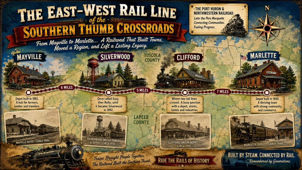
One route ran east and west through:
Mayville ? Silverwood ? Clifford ? Marlette
Another ran north from the Lapeer County area through:
North Branch ? Clifford ? Kingston
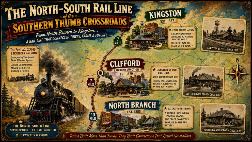
Clifford stood where the two routes crossed. That gave the small village an important role as a railroad junction, freight transfer point, and passenger stop.
The rail lines also linked these communities with larger markets. Farm products could be shipped to cities, while coal, tools, building materials, store merchandise and household goods arrived by train.
Before paved highways and dependable automobiles, the local depot served as a community’s connection to the outside world.
Marlette: A Depot, Main Street and a Major Train Wreck
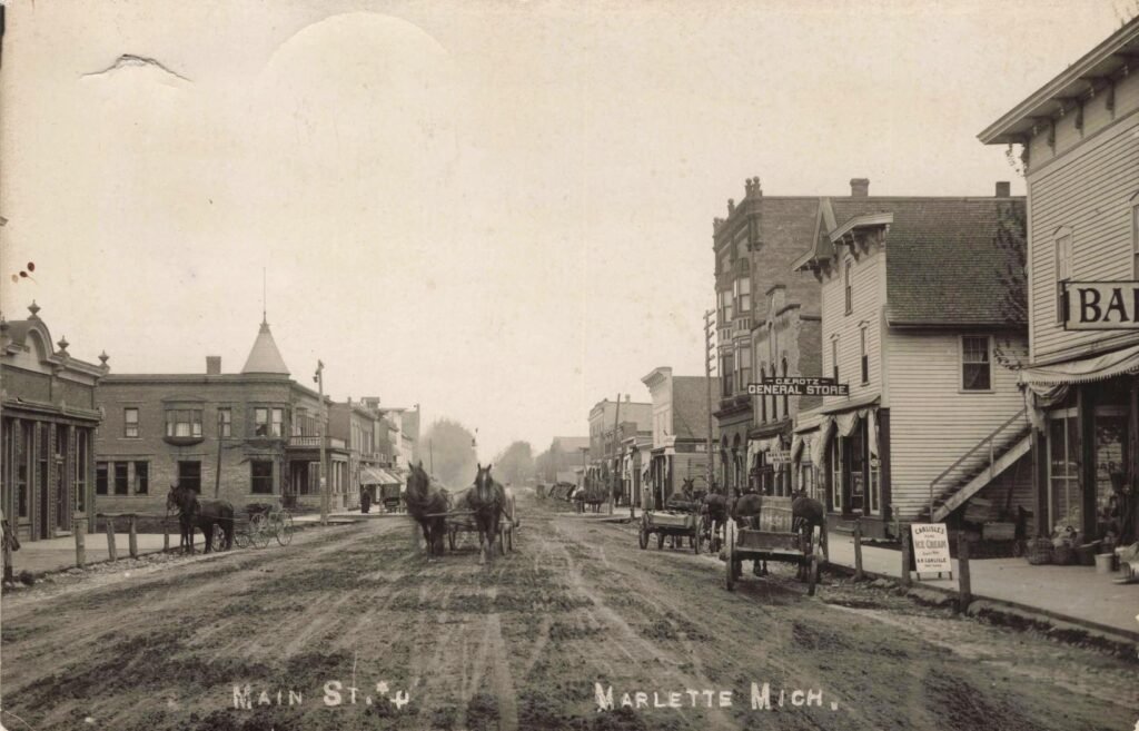
Marlette has the largest group of stories in this Southern Thumb history collection.
The railroad helped turn the community into a commercial center for western Sanilac County. Its depot handled passengers, baggage, mail and freight during an era when train arrivals were part of daily village life.
The restored Marlette depot remains one of the region’s strongest physical links to that period. It now serves as a local museum and gathering place.
Marlette Train Depot
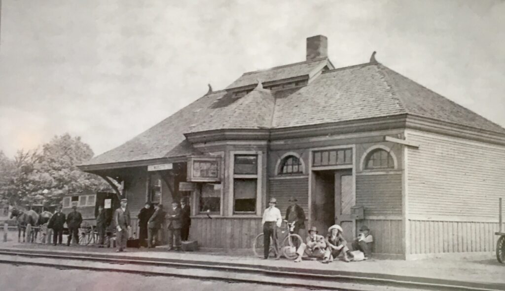
The Michigan Moments video shows the depot and explains how railroad service helped Marlette grow.
Watch: Marlette Train Depot
Read: Marlette Train Depot — Beautifully Restored History
North Main Street in Marlette
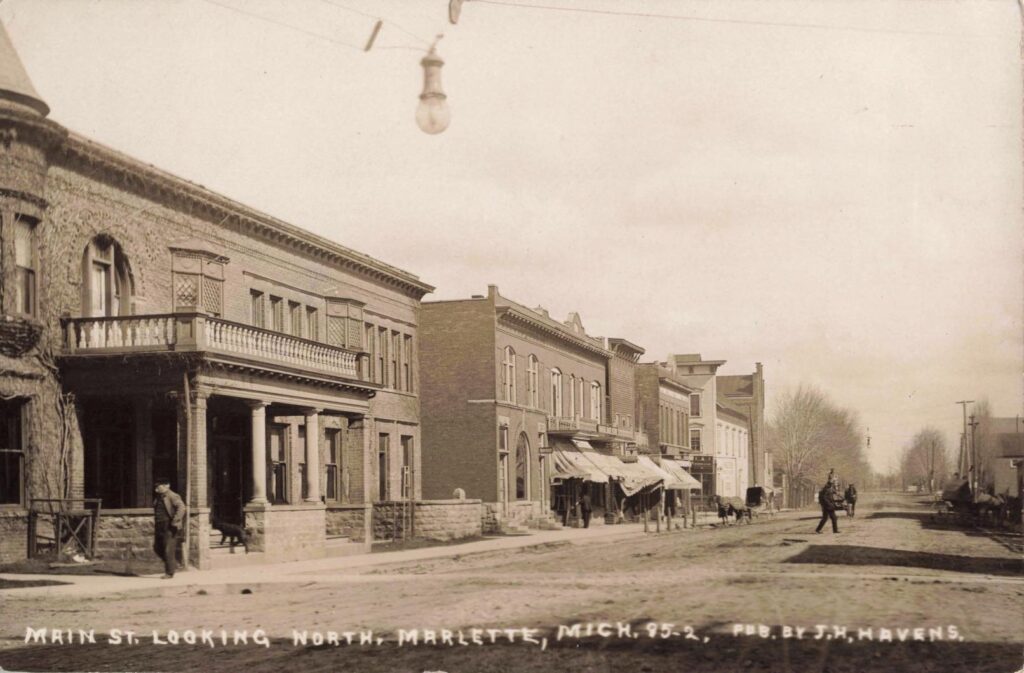
Historic photographs of North Main Street show the businesses, homes, vehicles and people who shaped the town during the early 1900s.
These street scenes provide a closer look at Marlette, Michigan history beyond the railroad tracks. They show a growing town adjusting to electricity, automobiles and changing retail habits.
Watch: A Historic View of North Main Street in Marlette
The 1913 Pere Marquette Train Wreck
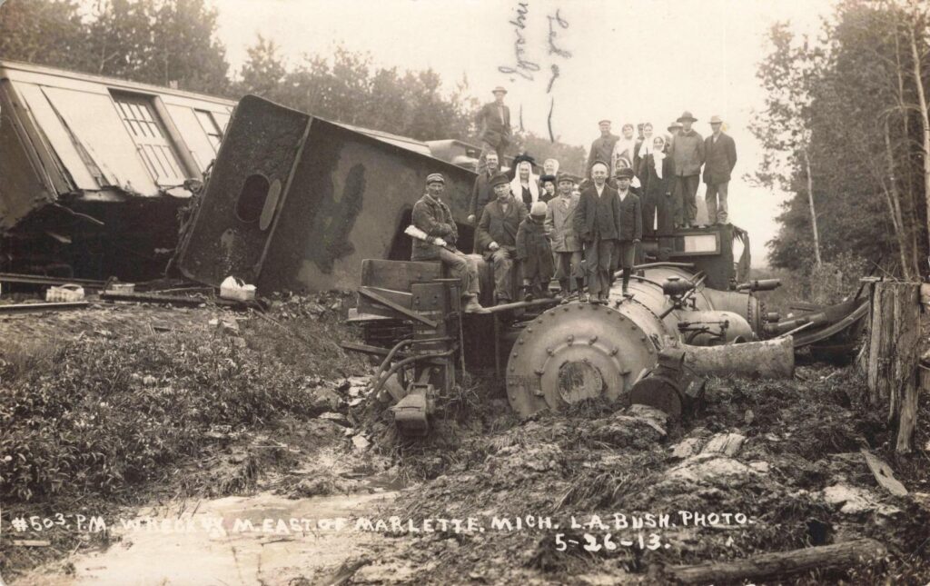
Marlette’s railroad story also includes a dramatic accident.
In 1913, a Pere Marquette passenger train derailed outside the city. The locomotive overturned, cars left the tracks and local residents gathered around the wreckage.
Four surviving photographs record the scene. They show the damaged train, the broken track and crowds standing near the overturned engine.
Read: The 1913 Pere Marquette Train Wreck Near Marlette
Together, the three Marlette stories show both sides of the railroad era. Trains brought jobs, commerce and mobility, but accidents could turn a routine trip into a community emergency.
Clifford: The Junction at the Center of the Region
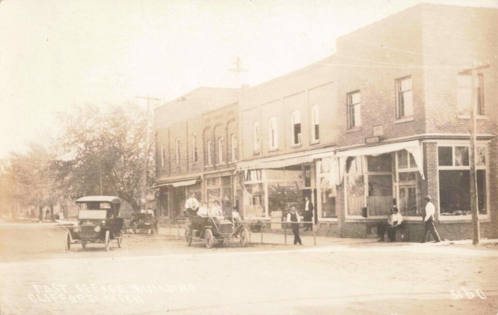
Clifford may be the smallest town in this collection, but its location made it one of the most important.
Two railroads crossed near the village. The junction connected the east-west route between Mayville and Marlette with the north-south route between North Branch and Kingston.
The railroad helped support hotels, stores, blacksmith shops, lumber businesses, creameries and other local industries. Passengers could transfer between trains, while freight moved from one railroad system to another.
The arrival of the tracks also affected Clifford’s physical growth. Businesses developed near the railroad crossing as well as within the older portion of the village.
How Lumber, Creameries and Railroads Built Clifford
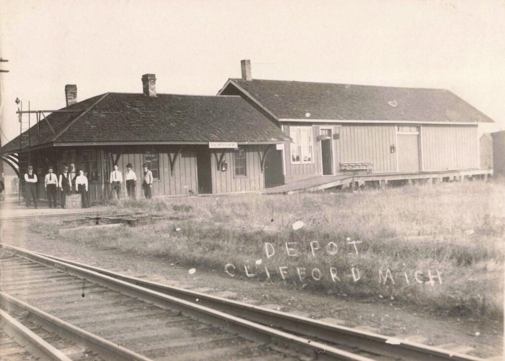
This Michigan Moments episode follows Clifford through its lumber years, agricultural development and railroad period.
Watch: Clifford — How Lumber, Creameries and Railroads Built a Town
Clifford gives The Southern Thumb Crossroads its central theme. The town shows how a small junction could hold regional importance far beyond its population.
North Branch: From Timber Settlement to Farm Center
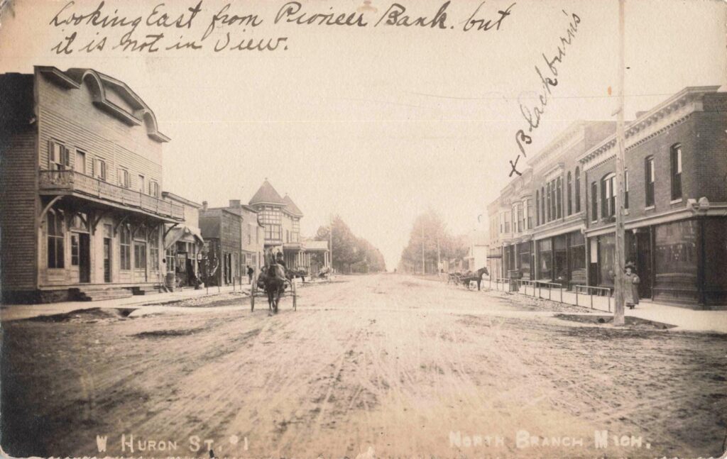
North Branch developed along the north branch of the Flint River during the 1850s.
Timber supported the community’s early economy. As the surrounding forests were cleared, farming became more important. Stores, mills, and service businesses grew around the needs of local families.
The railroad later gave North Branch farmers and merchants a more dependable route to outside markets. The depot handled passengers and freight while connecting the town with Clifford and communities farther north.
Historic photographs show Main Street storefronts, horse-drawn vehicles, early automobiles, schools, public buildings and railroad activity.
The History of North Branch
The North Branch Michigan Moments video uses 12 historic photographs to show the town’s growth and changing appearance.
Watch: The History of North Branch, Michigan
Read: History of North Branch, Michigan
North Branch represents the southern gateway to this regional story. It was one of the first communities encountered by travelers heading north into the Thumb by rail.
Mayville: A Village Shaped by Its Depot
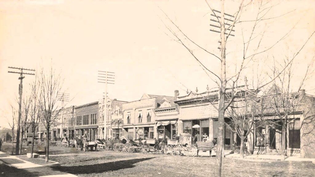
Mayville began as a small settlement serving farmers and timber operations in southern Tuscola County.
Railroad service helped the village become a shipping and commercial center. The depot handled farm products, lumber, passengers, mail, and supplies ordered by local merchants.
Historic images show downtown Mayville during the early 1900s, when horse-drawn wagons shared the streets with the first automobiles. Storefronts stood close together, and the railroad remained one of the town’s main connections with the rest of Michigan.
Mayville later saved its former depot and converted it into a local history museum. The decision preserved one of the buildings most closely tied to the village’s early growth.
Mayville in the Early 1900s
This Michigan Moments episode presents historic photographs of downtown businesses, residents and transportation.
Watch: Mayville — A Look Back in the Early 1900s
Mayville’s story shows why surviving depots matter. Without the station, it would be harder to understand how the village became a regional farm market.
Kingston: A Farm Town on the Route North
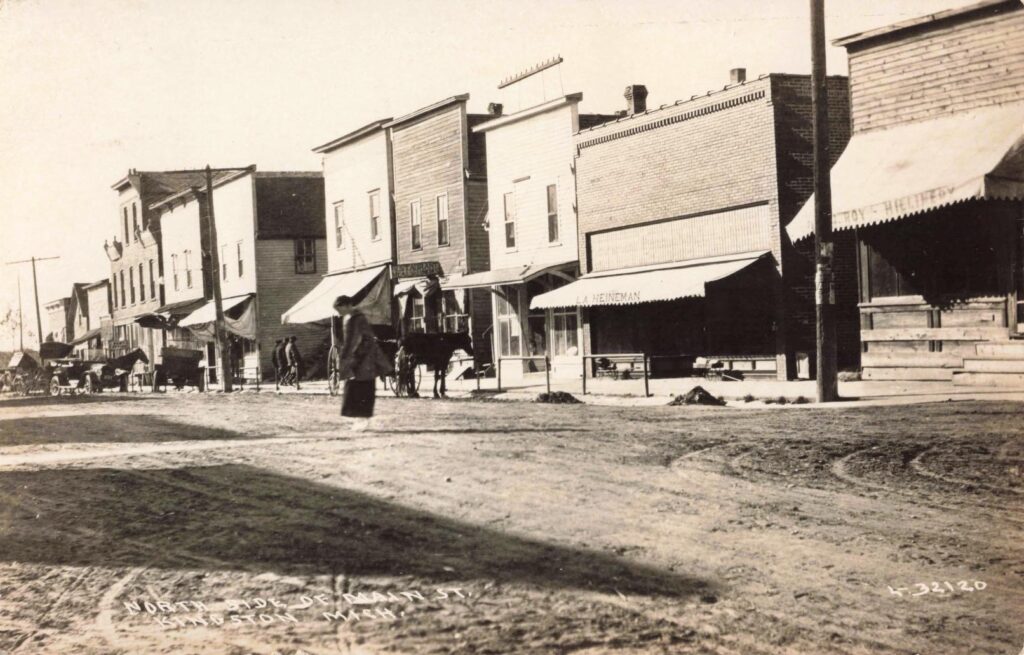
Kingston stood along the railroad route running north from Clifford into Tuscola County.
The depot provided area farmers and businesses with access to larger shipping markets. Crops, livestock and other products could leave town by rail. Merchandise, tools, equipment, mail and passengers arrived in return.
Historic Kingston photographs show a busy Main Street filled with local businesses. Wagons, early automobiles and groups of residents provide evidence of a town serving a broad rural area.
The railroad was not Kingston’s only reason for existing, but it strengthened the town’s role as a commercial center.
The History of Kingston
The Kingston Michigan Moments episode follows the community from its early settlement through its railroad and business years.
Watch: The History of Kingston, Michigan
Read: Kingston, Michigan History
Kingston’s history represents the quieter side of the railroad era. It was not a major junction, but its depot provided an essential service for farmers, merchants and families.
Silverwood: The Railroad Town With Three Names
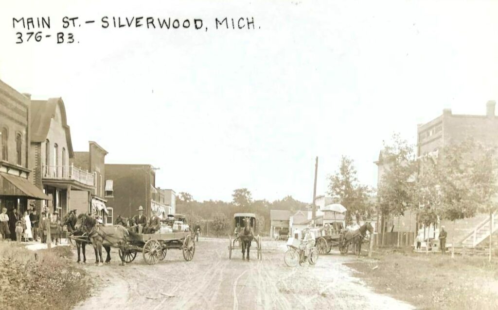
Silverwood has one of the most unusual naming stories in the region.
The community was once called Easy. It later became Rollo before receiving the name Silverwood.
The town developed along the railroad between Mayville and Clifford. Its depot, siding and water facilities supported passenger and freight service.
Steam locomotives required regular water stops. That need gave small railroad communities an operational role even when passenger and freight business remained limited.
Silverwood never grew into a large incorporated village. It remained a small settlement centered on the depot, post office, store and nearby homes.
Easy, Rollo and Silverwood
The Silverwood Michigan Moments episode uses 12 historic images to explain how the railroad town changed names and developed around the tracks.
Watch: History of Silverwood, Michigan
Read: History of Silverwood, Michigan — A Railroad Town Once Called Easy and Rollo
The town’s changing names provide one of the most memorable stories in Thumb railroad history.
From Lumber Camps to Farm Markets
The six communities followed a similar economic path.
Timber supported many of their first businesses. Sawmills, shingle mills, blacksmith shops and wagon makers served settlers clearing land for homes and farms.
The timber economy eventually declined. Farms took its place.
Railroads began carrying grain, beans, livestock, dairy products and other agricultural goods. Grain elevators, creameries, farm suppliers and general stores became central parts of village commerce.
This change allowed the towns to survive after the most valuable forests were gone. Their role shifted from serving lumber operations to supporting farm families spread across the surrounding townships.
Fires, Accidents and Other Threats
Life in the Southern Thumb was not easy during the late 1800s and early 1900s.
Major forest fires struck Michigan’s Thumb during the settlement era. Wooden downtown buildings were also vulnerable to smaller local fires.
Railroad accidents added another risk. The 1913 wreck near Marlette remains one of the best-documented examples because four photographs survived.
Poor roads, severe winters, crop failures and economic downturns also affected local families and businesses.
The communities rebuilt because they continued to serve practical needs. Residents still required stores, schools, churches, mills, depots and places to sell farm products.
What Happened When the Trains Stopped?
Railroad service began losing importance as automobiles and improved roads changed travel.
Passenger service declined. Freight operations became more centralized. Local railroad agents disappeared, depots closed and some tracks were removed.
The results can still be seen today.
Marlette preserved its depot. Mayville moved and saved its station. Other towns lost most of their railroad buildings.
In places such as Clifford and Silverwood, little remains to show how active the tracks once were. Historic photographs and local records now provide much of the evidence.
That makes preservation important. A depot, storefront or old photograph can explain a town’s history more clearly than a date on a plaque.
Let’s Travel the Southern Thumb Crossroads
The old railroad routes can still serve as a guide for a regional history trip. These little road trips offer something unique to do in Michigan’s Thumb.
East-West Route
Follow the former east-west railroad corridor through Mayville, Silverwood, Clifford and Marlette. Stops include restored depots, former station sites, historic churches, a Carnegie library and the junction where two Thumb railroads crossed.
Mayville ? Silverwood ? Clifford ? Marlette
This route follows the towns once linked by the east-west railroad corridor.
Southern Thumb Crossroads: Mayville to Marlette Heritage Route
1. Mayville Area Museum and Historic Depot
2124 E. Ohmer Road, Mayville
The museum occupies Mayville’s former depot and contains regional artifacts, genealogy records, cemetery information and a one-room school display. The current museum site is separate from the depot’s original station location, which is also marked in the KML file.
2. Silverwood Station Site
Coordinates: 43.325000, -83.247222
This point marks the historic Silverwood station area. Period photographs show the depot, water tower, passenger trains and railroad maintenance workers. The location is a historical stop rather than a staffed attraction.
3. Historic Silverwood Methodist Church Exterior
2750 Clifford Road, Silverwood
Built in 1889, the former church remains one of Silverwood’s most recognizable older buildings. The congregation closed in 2023, and the property has been offered for sale. It should be treated as an exterior-view stop unless new ownership provides public access.
This stop is included in the KML but not in the simplified Google driving link.
4. Clifford Community Park and Village Center
Near 4548 Madison St., Clifford
The park provides a practical place to stop near the village center. It is also close to the district where Clifford’s businesses grew around the intersecting rail lines.
5. Clifford Station and Railroad Junction Site
Coordinates: 43.316667, -83.179722
The Port Huron and Northwestern route crossed the north-south Pontiac, Oxford and Northern line here. A union depot handled traffic from both railroads. Records indicate the depot had been removed by 1960.
This historical point is included in the KML. It is close enough to the park and church that visitors can view Clifford’s major locations during one stop.
6. St. Patrick’s Church Historical Marker
9851 Main St., Clifford
The congregation began in 1879, and the Gothic-inspired church was built during the 1880s. It once served Catholic families from Clifford, Marlette, North Branch, Mayville, Kingston, Silverwood and Wilmot. The site carries Michigan Historical Marker L1646.
7. Marlette Train Depot Museum
3325 Main St., Marlette
The restored depot was built in 1890. Marlette residents had raised $15,000 to help bring the railroad into town, making the depot one of the route’s strongest surviving links to the rail era. The property is both a museum and a Michigan historical marker site.
8. Methodist Episcopal Church Historical Marker
Near 3155 Main St., Marlette
The Neo-Gothic church was dedicated in 1902. It survived major fires in 1937 and 1979 while retaining its historic exterior. The site carries Michigan Historical Marker L2121.
9. Marlette District Library Historical Marker
3116 Main St., Marlette
Built in 1921, the Carnegie library was the last in the Midwest to receive a Carnegie library grant and the second-to-last in the nation. It makes a strong final stop because it is near the church and only a short distance from the depot.
Museum Hours Note
The Mayville museum currently lists seasonal hours from 11 a.m. to 3 p.m. Fridays and Saturdays between Memorial Day weekend and Labor Day, with special tours available. The Marlette museum lists Sunday hours from 2 to 5 p.m. from May through October, or visits by appointment. These hours should be verified shortly before the hub page is published.
Visitors can see Mayville’s preserved depot, pass through the former railroad community of Silverwood, stop at the Clifford junction area, and continue to Marlette’s restored station.
North-South Route
Follow the old north-south railroad corridor from North Branch through Clifford to Kingston. Stops include a local museum, historic bank, veterans memorial, former station sites, Clifford’s two-railroad junction, St. Patrick’s Church and Kingston’s restored depot.
North Branch ? Clifford ? Kingston
This route follows the former north-south line.
Southern Thumb Crossroads: North Branch to Kingston Heritage Route
1. Orr Family Museum and Daniel Orr Sons Marker
Jefferson Street near Huron Street, North Branch
The Orr Family Museum contains local artifacts and exhibits tied to North Branch history. Nearby, a Historical Society of Michigan plaque recognizes Daniel Orr Sons, founded in 1875, as a Michigan Centennial Business. Museum hours were not reliably posted online and should be checked locally before a visit.
2. Pioneer State Bank No. 36
4046 Huron St., North Branch
The existing bank opened in 1906 after an earlier building under construction burned. The Renaissance Revival building is a Michigan State Historic Site and is listed on the National Register of Historic Places.
3. North Branch Veterans Memorial and Memorial Park
Near 4295 Huron St., North Branch
The public memorial stands near Brush Street and honors area military veterans. Memorial Park also offers a convenient break before continuing north toward Clifford.
4. North Branch Station Site
Approximate coordinates: 43.22790, -83.18920
North Branch stood on the Pontiac, Oxford and Northern line running toward Caseville. The railroad later became part of the Grand Trunk Western system. The historic depot no longer survives, so the map uses an approximate location rather than claiming an exact building footprint.
5. Clifford Community Park and Village Center
Near 4548 Madison St., Clifford
This provides a practical public stopping point near Clifford’s older village center. From here, visitors can continue north to the former railroad junction and St. Patrick’s Church.
6. Clifford Railroad Junction and Depot Site
Approximate coordinates: 43.316667, -83.179722
Clifford was where the north-south Pontiac, Oxford and Northern crossed the east-west Pere Marquette route. A union depot served both lines, and records show that both railroads ran multiple daily trains through Clifford in 1911. The depot had been removed by 1960.
7. St. Patrick’s Church Historical Marker
9851 Main St., Clifford
The Catholic congregation began in 1879, and the Gothic-inspired church was built during the 1880s. St. Patrick’s once served families from Clifford, Marlette, North Branch, Mayville, Kingston, Silverwood and Wilmot, making it a strong link between both Southern Thumb routes.
8. Kingston Village Hall and Historic Center
3655 Ross St., Kingston
The village hall makes a useful orientation point near Kingston’s historic business district. Kingston was incorporated in 1893 and developed beside the railroad running north from Clifford.
9. Kingston Restored Railroad Depot
Approximate location near the village center
Railroad records identify Kingston as a stop on the Pontiac, Oxford and Northern, later Grand Trunk Western, about seven miles north of Clifford. The source also documents a restored depot photographed in 2003. A current official visitor page listing regular depot hours could not be found, so public access should be confirmed locally.
10. Kingston Cemetery
M-46 at Cemetery Road, east of Kingston
The community cemetery lies less than a mile east of the village on the south side of M-46. It provides a connection to the families who settled Kingston and nearby rural townships. Visitors should enter respectfully and during daylight.
North Branch offers a traditional downtown and local-history sites. Clifford marks the former railroad junction. Kingston provides another example of a small agricultural community shaped by train service.
Not every historic structure remains. The videos and photographs in this collection help identify buildings, streets and railroad sites that might otherwise be overlooked.
Why We Love The History of Michigan’s Southern Thumb
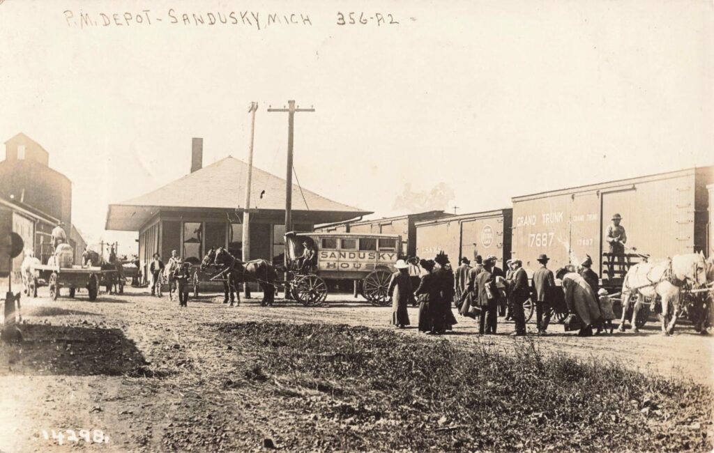
Southern Thumb history is the story of ordinary communities adapting to major economic and transportation changes. The towns began with timber, rivers, rough roads, and small farms. Railroads then brought faster transportation, new businesses and regular contact with larger cities. Southern Thumb festivals and events occur most weekends during the summer.
Automobiles and highways later reduced the importance of local depots. Some towns continued to grow, while others became smaller and quieter. Their histories show that Michigan small towns did not develop alone. They depended on regional connections that crossed county lines.
Marlette, Clifford, North Branch, Mayville, Kingston, and Silverwood shared trains, markets, workers, customers, and common risks. Together, they form The Southern Thumb Crossroads.
These six towns may appear separate on a modern map. Their old railroad routes tell a different story.
See more Michigan Moments episodes and historic Michigan communities