
 by
by 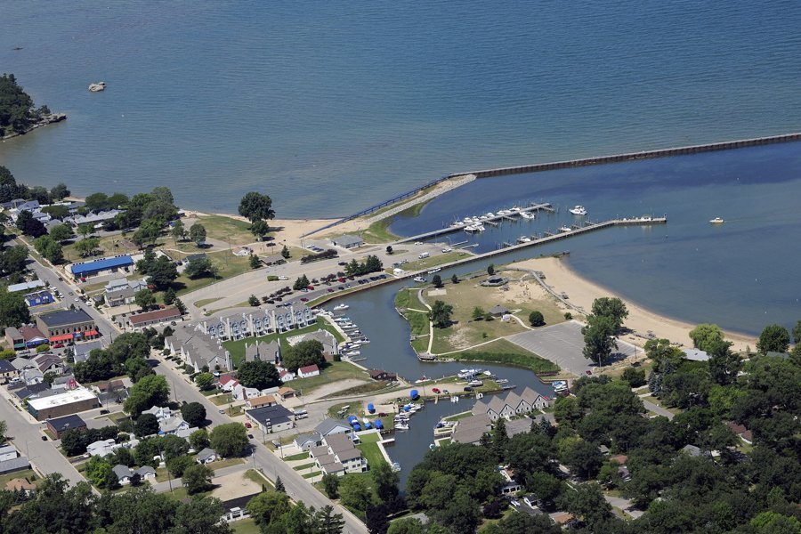
Most travelers view the Michigan Thumb as a simple collection of beach towns; however, the shoreline from Caseville to Port Austin actually serves as a 150-mile record of maritime survival and industrial grit. You likely want to see the iconic rock formations and Great Lakes sunsets, but the logistics of navigating rural Huron County often prove frustrating when cell service drops or crowds overwhelm the popular trails. Planning a successful trip requires more than just a GPS and a swimsuit.
This Michigan Thumb weekend itinerary provides a logistical breakdown of a three-day loop starting from the southern gateways. It ensures you spend more time at documented historical sites and less time searching for a signal or an open parking spot. We’ll outline a clear driving route along M-25, identify key landmarks like the Sanilac County Historic Village and Museum, and provide practical tips for visiting spots like Turnip Rock without the typical peak-summer headaches. You’ll find the data needed to navigate the coast while respecting the agricultural heritage that built these communities.
Key Takeaways
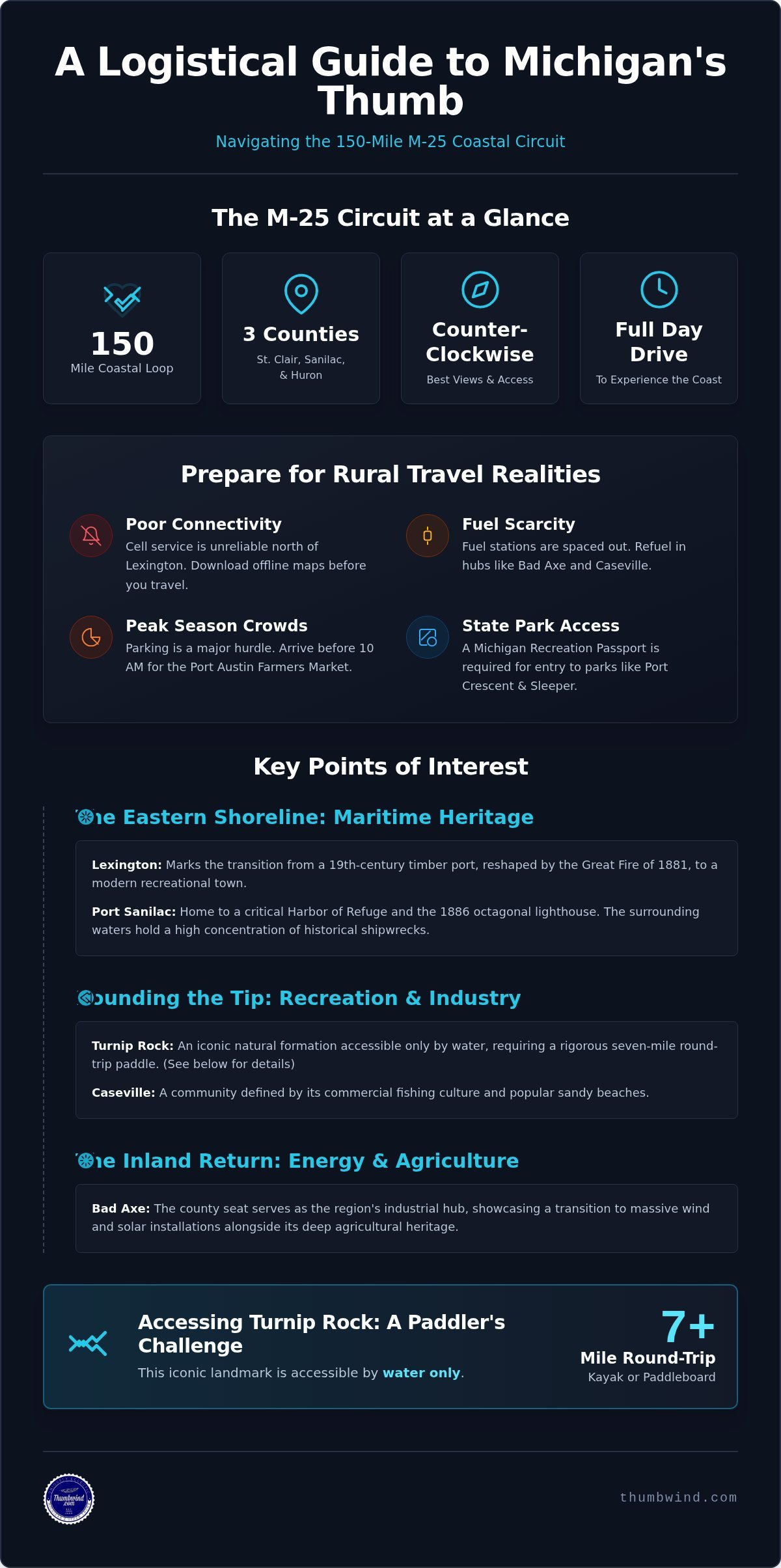
- Navigate the 150-mile M-25 circuit while preparing for significant cellular dead zones north of Lexington in Sanilac County.
- Locate essential maritime landmarks like the Port Sanilac harbor of refuge along the eastern Lake Huron shoreline.
- Follow this Michigan Thumb weekend itinerary to manage the rigorous seven-mile round-trip paddle required to view Turnip Rock from the water.
- Transition from the commercial fishing culture of Caseville to the massive wind and solar installations found near the county seat of Bad Axe.
- Identify documented historical sites and local parking logistics to avoid the most overcrowded spots during the peak summer season.
Mapping the M-25 Circuit: Logistics for a Thumb Region Road Trip
M-25 serves as the main artery for any Michigan Thumb weekend itinerary, tracing the shoreline for nearly 150 miles. St. Clair, Sanilac, and Huron counties form the distinct shape of Michigan’s Thumb region, each offering a different perspective on the state’s maritime and agricultural history. To get the best views of the Lake Huron sunrise, start your loop in Port Huron and head north. This counter-clockwise direction keeps the water on the passenger side of the vehicle, making it easier to pull into scenic turnouts without crossing traffic.
Route Planning from Detroit and Grand Rapids
Drivers coming from the Detroit area typically access the region via I-69 toward Port Huron or M-53 for a direct shot into the heart of Huron County. From Grand Rapids, the drive to the base of the Thumb takes roughly 2.5 hours before you even reach the shoreline. While a straight drive from Port Huron to Port Austin takes about two hours, you should plan for a full day of travel to account for small-town speed limits and historical stops. Following the coast is slower than the inland M-53 route, but it provides the essential context of the region’s lighthouse and harbor system.
The Reality of Seasonal Crowds and Connectivity
Logistics in rural Michigan require preparation because digital tools often fail. Cell service becomes notoriously unreliable once you move north of Lexington in Sanilac County. You shouldn’t rely on live GPS for navigation; instead, download offline maps or carry a physical atlas. Fuel stations are also spaced out, with major pumps concentrated in hubs like Bad Axe and Caseville. If you’re coming from out of state, remember that a Michigan Recreation Passport is required for entry into state parks like Port Crescent or Sleeper State Park.
Parking is another logistical hurdle, especially during peak summer months. The Port Austin Farmers Market on Saturdays attracts thousands of visitors, often filling every legal street spot by 10 a.m. If you’re planning a Michigan Thumb weekend itinerary during the Saturday market, arrive early or prepare to walk several blocks from the village periphery. These small-town infrastructures weren’t built for modern tourist volumes, so a bit of skepticism toward “quick” stops will save you time.
The Eastern Shoreline: Maritime History from Lexington to Port Sanilac
Lexington sits at the southern edge of the Thumb, serving as the first major stop for travelers moving north from the Detroit metro area. While many modern visitors see it as a weekend destination for shopping, its layout was originally dictated by the 19th-century timber industry. The fire changed everything. The village served as a vital shipping point for white pine before the Great Fire of 1881 swept through the region, destroying over a million acres and forcing these communities to pivot from lumber to agriculture and tourism.
Lexington and the Early Timber Industry
In the 1800s, the lumber boom created a flurry of activity along the docks. You can still find historical markers throughout the village that detail this transition from industrial port to recreational hub. For a deeper look at how these settlements evolved, take a 60-second look at the historic village of Port Sanilac to see the preservation efforts in Sanilac County. Those interested in regular updates on regional history can subscribe to Michigan Moments for deeper insights into the Thumb’s past.
Lighthouses of the Sunrise Side
Port Sanilac features a harbor of refuge. In the late 19th century, these harbors served as critical safety zones where captains could anchor to escape the violent gales that frequently sank ships on the Great Lakes. This specific stretch of water is home to a high concentration of shipwrecks, providing a clear window into Lake Huron’s maritime heritage. The Port Sanilac Lighthouse, recognizable by its unique octagon shape, was built in 1886 to guide vessels toward this protected water.
Although the lighthouse is privately owned, it remains a prominent landmark for anyone following a Michigan Thumb weekend itinerary. Visitors should exercise caution when walking the breakwalls, especially during high winds, as waves can sweep over the concrete without warning. The structural integrity of these walls is vital for the harbor, but they are not designed for casual strolls during inclement weather. Accuracy in your route planning means respecting these boundaries while appreciating the engineering that has protected the coast for over a century.
Rounding the Tip: Kayaking, Rock Hunting, and Caseville’s Commercial Fishing
Port Austin marks the northernmost point of any Michigan Thumb weekend itinerary. Here, the terrain transitions from the rugged Lake Huron coast to the shallower, warmer waters of Saginaw Bay. While many visitors arrive solely to see Turnip Rock, few realize it requires a seven-mile round-trip paddle that typically takes three to four hours. The rock formation sits on private property, meaning there is no public land access; you must view it from the water.
Day Two: Port Austin to Caseville Itinerary
Start your second day with morning rock hunting at the public beaches near Pointe Aux Barques, where the currents often deposit unique stones. If your trip falls on a Saturday, the Port Austin Farmers Market is essential for local provisions before heading west toward Caseville. Caseville’s identity remains tied to its roots as a commercial fishing hub, specifically the legacy of the Gillingham fishing docks in Caseville. This family-operated industry helped sustain this agricultural community long after the timber boom ended.
Geological Features and Saginaw Bay
Just east of Port Austin lies Grindstone City, named for the unique sandstone quarries that once supplied the world with industrial sharpening wheels. The industry collapsed with the advent of synthetic abrasives, but the discarded stones still line the harbor today. Moving west, Sleeper State Park provides bird-watching opportunities within its ancient dune forests. For hikers, the Steel Bridge Trail in Port Crescent State Park offers a view of the Pinnebog River as it enters the bay.
The Saginaw Bay side of the peninsula offers a distinct climate, often feeling several degrees warmer than the Lake Huron side during the summer months. This shift in temperature influenced the development of the region’s resorts and seasonal cottages, creating a different atmosphere for travelers rounding the tip. Shallow waters in the bay allow for faster heating, which historically supported longer swimming seasons for the local communities. Including both coasts in your Michigan Thumb weekend itinerary provides a complete view of how geography dictated the survival of these small towns.
The Inland Return: Bad Axe Industry and Agricultural Heritage
Bad Axe serves as the industrial and political heart of Huron County. While the coast offers scenery, the interior provides the economic engine that sustains the region. Historical records indicate the city’s unusual name originated in 1861 when surveyors Rudolph Papst and George Pack found a badly damaged tool at their campsite. This inland portion of a Michigan Thumb weekend itinerary reveals a different side of the region, where the horizon is dominated by massive utility-scale energy projects rather than lighthouses.
Agricultural Powerhouse and Modern Energy
The Thumb has evolved into Michigan’s renewable energy leader. Driving south on M-53, you’ll pass through an extensive Michigan wind farm map and several Michigan solar farm installations. Agriculture remains the primary driver, with sugar beets serving as the cornerstone of the local economy. For those extending their stay beyond the coast, Michigan State Campgrounds and DNR systems offer several inland spots that provide a quieter alternative to the crowded shoreline parks.
The Vassar Depot and Rail History
Continuing south toward Detroit or Flint, the route through Vassar highlights the region’s rail heritage. The Michigan Central Railroad depot in Vassar stands as a reminder of the era when timber and grain moved by steam. This rail connection was vital for linking the remote settlements of the Thumb to the industrial markets of Detroit. Exploring these inland hubs often leads to Michigan Ghost Towns and abandoned industrial settlements where the tracks have long since been removed, leaving behind only concrete foundations and local lore.
Before merging onto M-15 or I-75 for the final leg home, conduct a final logistical check in Bad Axe or Vassar. These inland towns offer more consistent services and often lower fuel prices than the seasonal coastal villages. The transition from the quiet, expansive fields of the interior to the busy highways of southern Michigan marks the completion of the loop. This inland return rounds out the Michigan Thumb weekend itinerary by providing the industrial and agricultural context that made the coastal settlements possible.
Preparing for Your Journey Through the Thumb
A successful trip around the peninsula requires more than just a map. You’ve seen how the 150-mile circuit along M-25 connects the maritime heritage of Port Sanilac with the industrial fishing roots of Caseville. Navigating this Michigan Thumb weekend itinerary effectively means preparing for cellular dead zones and understanding the logistical demands of a seven-mile kayak trip to Turnip Rock. By balancing the scenic shoreline with the agricultural hubs of Bad Axe and Vassar, you gain a complete perspective on the region’s survival and growth.
Since 2009, Thumbwind has provided independent regional news and historical reporting based on primary sources and local archives. Our team brings over 15 years of Michigan journalism to every story, ensuring you have accurate data for your travels. Checking live regional webcams helps verify weather and water conditions before you arrive at the harbor.
The Thumb remains a place where the past is still visible in the architecture of its lighthouses and the layout of its farm fields. We hope this guide helps you appreciate the grit and resilience of these lakeside communities. Safe travels as you explore the sunrise side.
Frequently Asked Questions
How long does it take to drive around the Michigan Thumb?
Driving the full 150-mile loop along M-25 takes approximately four hours without stopping. Most travelers spend three days on their Michigan Thumb weekend itinerary to visit the museums and harbors along the way. The route consists mostly of two-lane roads with frequent speed limit changes in village centers. You’ll move slower through Lexington and Port Sanilac, so budget extra time for those coastal segments.
Where is the best place to stay during a Thumb weekend?
Port Austin and Caseville offer the highest concentration of seasonal rentals and motels. Port Austin serves as a convenient central hub for a Michigan Thumb weekend itinerary because it provides easy access to both the Lake Huron and Saginaw Bay shorelines. For a more secluded experience, state parks like Sleeper or Port Crescent provide campgrounds with direct beach access, though these spots often fill months in advance.
Is there cell service throughout the Michigan Thumb region?
No, cell service is notoriously unreliable in rural Huron and Sanilac counties. While coverage is generally stable in towns like Bad Axe or Lexington, it often drops to zero along remote stretches of M-25. Travelers should download offline maps or carry a physical atlas before heading north of Lexington. Don’t rely on live streaming or GPS navigation in the northernmost points of the peninsula where signals are weakest.
What are the best beaches for rock hunting in the Thumb?
The public beaches near Pointe Aux Barques and the shoreline at Port Crescent State Park are the most productive spots. These areas frequently reveal jasper, and unique quartz formations after a storm. Successful hunters often visit early in the morning before the summer crowds arrive. Remember that state law limits the amount of stones individuals can remove from public lands to 25 pounds per person per year.
Are the lighthouses in the Thumb open to the public?
Access to these maritime landmarks depends entirely on the specific site. The Pointe Aux Barques Lighthouse museum is open to the public during the summer, while the Port Sanilac Light remains a private residence. If you want to see the Port Austin Reef Light, you must book a specific boat tour, as it sits over two miles offshore. It’s best to verify tour dates in advance since they are limited.
What is the best time of year to visit the Thumb?
June through August is the peak season for water activities and outdoor markets. This window offers the most consistent weather for kayaking and visiting the Port Austin Farmers Market. However, September provides a quieter experience with cooler temperatures and reliable fishing conditions. Many businesses in these coastal villages are seasonal; they often close or reduce hours significantly after the Cheeseburger in Caseville festival concludes in late August.
Disclaimer
Information published on Thumbwind.com is provided for general informational purposes. While we make reasonable efforts to keep articles accurate and current, details such as prices, hours, regulations, access conditions, and other information may change without notice. Readers should verify important details with the appropriate business, agency or official source before making travel, financial or other decisions. Thumbwind.com is not responsible for the content, availability or practices of third-party websites linked from our articles.