 by

In 1855, Michigan opened a remarkable pair of stone locks at Sault Ste. Marie, allowing ships to bypass the St. Marys Rapids. Rare photographs preserve the engineering achievement, the growing shipping trade and the people whose lives were tied to the river.

Before the enormous freighters, steel gates, and concrete chambers of today’s Soo Locks, a river refused to cooperate with commerce.

At Sault Ste. Marie, the St. Marys River rushed over a rocky stretch between Lake Superior and the lower Great Lakes. The rapids created a formidable obstacle for large sailing vessels and steamboats. A ship could approach the falls, but it could not simply sail through them.
For generations, travelers worked around the problem by unloading cargo, moving goods overland and placing them aboard vessels on the other side. It was slow, expensive work, especially when the cargo included heavy equipment, copper, or iron. Then Michigan made an extraordinary decision: Rather than continue hauling freight around the rapids, it would build a passage that carried the ships themselves.
The result was the original Michigan State Locks, a pair of stone chambers that began commercial operation on June 18, 1855. The project helped change the economy of the upper Great Lakes and established Sault Ste. Marie as one of North America’s most important shipping passages.
Table of Contents
Watch: The First Soo Locks (1855) – When Michigan Cut a Road Through the Rapids
The First Soo Locks: A River Transformed
From Bahweting’s centuries-old fishing grounds to the opening of the State Locks in 1855, the St. Marys Rapids became the center of a Great Lakes transportation revolution.
Long Before 1798 Bahweting: The Place of the Rapids
Anishinaabe communities had lived, traded and gathered along the St. Marys River for generations before the American canal was constructed. The rapids were especially valuable for whitefish fishing, with skilled crews using dip nets from canoes.
The area was a center of regional travel and seasonal gatherings. The Soo’s history did not begin with a canal.
1798 An Earlier Lock Opens on the Canadian Side
The North West Company constructed a small lock on the Canadian side of the river to help freight canoes bypass the rapids.
It was an important predecessor to the American State Locks. Unlike the 1855 canal, however, the earlier structure was built for the fur-trade canoe economy rather than large commercial ships.
1814 War Ends the First Canadian Lock
American military forces destroyed the North West Company’s lock during the War of 1812.
The portage remained essential for moving goods around the rapids. As the mining trade grew during the following decades, this method became increasingly expensive and difficult.
Aug. 26, 1852 Congress Makes a 750,000-Acre Bet
Congress granted Michigan 750,000 acres of federal land to support the building of a ship canal around the St. Marys Falls.
The grant offered a means of financing construction without a conventional direct federal construction payment. Michigan moved forward with plans for two large tandem chambers.
June 4, 1853 Workers Begin Cutting a New Waterway
 Later view of the completed 1855 lock works.
Construction began under the St. Mary’s Falls Ship Canal Company. Charles T. Harvey directed the project, working from plans developed with government engineering expertise.
Crews faced a tight two-year schedule to excavate the canal, construct masonry chambers and install the wooden operating equipment.
May 31, 1855 Michigan Takes Possession of the State Locks
The completed canal and tandem locks were turned over to the state of Michigan.
Each chamber was approximately 350 feet long and 70 feet wide, with a lift of about 9 feet. Together, they formed an 18-foot staircase for vessels.
The formal transfer preceded the start of commercial navigation.
June 18, 1855 The State Locks Open — A New Era Begins
An unidentified steamer in the original State Locks; not confirmed as the first vessel.The steamer Illinois became the first vessel to pass through the new locks when commercial navigation began on June 18.
Ships could now move past the rapids without unloading all their cargo for an overland transfer.
The State Locks transformed Lake Superior’s connections with markets and industry throughout the lower Great Lakes.
1855 Navigation Season 149 Steamers and 44 Sailing Vessels
From June 18 through Nov. 23, the new canal handled 149 steamers, 44 sailing vessels and more than 8,000 passengers.
These first-season numbers confirmed that the engineering system could support meaningful commercial traffic.
The Soo quickly became an important connection between Upper Peninsula mining districts and the rest of the Great Lakes.
1860s–1880s Two Routes Share the Same River
A historic view traditionally dated about 1865; a conflicting published date exists.Commercial vessels traveled through the new canal while Anishinaabe fishermen, guides and other local residents continued using the rapids and surrounding river.
The photograph shows the canal, sailing masts, waterfront buildings and the natural river passage in one scene.
Its inscription dates the picture about 1865, but a related published version gives a different date. The exact photographic year remains unresolved.
1881 Federal Control and the Weitzel Lock
The federal government assumed possession of the locks on June 9, 1881. The larger Weitzel Lock opened on Sept. 1.
The new chamber reflected a shipping economy that had already outgrown the limits of the original State Locks.
Control of the American canal had shifted from Michigan to the federal government.
1887–1896 The Original State Locks Disappear
Demolition of the 1855 State Locks began in 1887 as the federal complex expanded.
The first Poe Lock opened in 1896, bringing another major increase in capacity.
The original chambers were disappearing, but the transportation route established in 1855 would remain essential to Great Lakes shipping.
Late 1800s–1902 John Boucher and the Living Rapids
John Boucher in a wooden boat at Sault Ste. Marie.The expanding lock system changed commercial shipping, but the natural rapids continued to attract fishermen, visitors and skilled local guides.
John Boucher, a noted Anishinaabe river guide and rapids pilot, became well known for his command of the currents.
Boucher died in 1902. His photograph records a river tradition that existed alongside the industrial canal.
Before the First Soo Locks, the Rapids Were Already a Highway
The story of the locks begins long before American canal builders arrived.
The Anishinaabeg knew the area as Bahweting, or the place of the rapids. The Sault Ste. Marie Tribe of Chippewa Indians identifies this part of the St. Marys River as a longstanding gathering place and center of fishing, travel and community life.

Whitefish were especially important. Skilled fishing crews maneuvered canoes among the rushing currents, using dip nets to catch fish in the rapids. Families gathered seasonally, and the river supported trade and travel throughout the upper Great Lakes.
European fur traders recognized the location’s value. In 1798, the North West Company built a small navigation lock on the Canadian side of the river. Intended for freight canoes, it was an early attempt to avoid the difficult portage. American forces destroyed the structure during the War of 1812 in 1814.
That earlier Canadian structure is an important distinction. The 1855 Michigan project was not the first lock of any kind at the Sault. It was the first major American ship canal and lock system built there. By the 1840s, growing American demand for Lake Superior copper and Upper Peninsula iron made the old freight-transfer system increasingly impractical.
What had once been a difficult interruption in a fur-trade route was becoming a major problem for an industrial economy.
Congress Offered Michigan Land Instead of Cash
The federal government recognized the problem. On Aug. 26, 1852, Congress approved a measure granting Michigan 750,000 acres of federal land to support construction of a ship canal around the St. Marys Falls.

The land grant was unusual by modern standards. Rather than provide a conventional construction appropriation, Congress gave Michigan property whose value could help finance the project. Michigan arranged for the St. Mary’s Falls Ship Canal Company to undertake construction. Business interests associated with the Fairbanks Scale Company backed the undertaking.
Charles T. Harvey became the central figure in completing the canal. A young businessman in his 20s, Harvey helped organize the work and directed construction efforts. Capt. Augustus Canfield of the U.S. Topographical Engineers had prepared the original survey and plans.
The schedule was demanding. Workers had only two years to complete an ambitious waterway at a relatively remote northern site. On June 4, 1853, construction began.
Building a Stone Staircase for Ships
The project required far more than cutting a ditch. Crews had to excavate a canal, construct substantial masonry walls, and install heavy wooden gates capable of controlling enormous quantities of water. Equipment, supplies, stone and food had to reach the worksite while construction continued through northern Michigan’s demanding seasons.
The finished canal measured about 5,548 feet long, with a water-surface width of about 100 feet. Its most important features were two stone lock chambers positioned one behind the other. Each measured about 350 feet long and 70 feet wide, with approximately 12 feet of depth.
Each chamber raised or lowered vessels about 9 feet. Together, they formed a two-step water staircase around the rapids.

The system relied on gravity. When a ship entered a chamber, operators closed the gates and allowed water to flow in or out until the vessel reached the next level. Workers used hand-operated capstans and mechanical connections to move the heavy wooden gates. According to historic engineering documentation, a chamber could fill in roughly seven minutes.
The project was a remarkable feat for its time. Historic American Engineering Record documentation gives the construction cost as $999,802.46, just under $1 million in 1850s dollars. More importantly, it established a practical route that let commercial vessels pass the falls without transferring their cargo.
June 18, 1855: Lake Superior Shipping Changes Forever

Michigan formally took over the completed canal on May 31, 1855. Commercial navigation began June 18. Michigan history records identify the steamer Illinois as the first boat to pass through the new locks that day.
It was a turning point for northern shipping. Previously, a vessel reaching the rapids had to surrender its cargo to the portage system. Now the entire ship could move through the canal. Instead of days of unloading, hauling and reloading, ships could pass through the new locks in a fraction of that time.
The first navigation season lasted from June 18 through Nov. 23, 1855. Historic American Engineering Record figures show that 149 steamers and 44 sailing vessels used the canal during that abbreviated season, carrying more than 8,000 passengers.
Those were modest numbers compared with the enormous cargo volumes the Soo would later handle. But they demonstrated that the canal worked. The locks did not create a route into an empty country. They allowed much larger ships and heavier cargo to move along waterways people had used for generations.
A Steamship Inside the Old State Locks
One photograph from the historical collection makes the scale of the original engineering achievement especially clear.
A steamboat sits inside a lock chamber, its tall smokestacks rising above the surrounding wooden and stone structures. People can be seen aboard the vessel, while the lock walls and gates frame the scene.
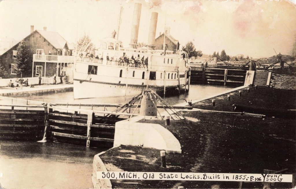
It is tempting to identify this vessel as the Illinois, the steamer credited with making the first passage. However, the photograph does not contain enough verified information to support that claim.
The image does show the close relationship between shipbuilding and canal engineering. Larger vessels needed larger locks, while better canals encouraged the development of bigger ships. This cycle would soon overwhelm the original State Locks.
Copper, Iron and a Growing Great Lakes Economy
The economic effects reached far beyond Sault Ste. Marie. The Keweenaw Peninsula’s copper mines needed efficient transportation to manufacturers and markets. Iron mines across Michigan’s Upper Peninsula faced a similar challenge.
Water transport offered a practical way to ship large quantities of heavy material. The new canal connected Lake Superior ports more directly with Lake Huron, Lake Erie, and the industrial cities of the lower Great Lakes. As shipping increased, communities around the upper lakes gained better access to machinery, manufactured goods, food, and other supplies.
The locks also encouraged new investment in ships, docks, warehouses, and mining operations. Sault Ste. Marie became more than a stopping point beside a difficult river. It was becoming a major transportation center.
Yet the canal’s success created its own problem. Vessels continued growing longer, wider and deeper. A chamber built to accommodate the commercial fleet of the early 1850s was increasingly inadequate only a few decades later.
John Boucher: The Man Who Knew the Rapids
Not every important figure in the story of Sault Ste. Marie worked inside the canal. The fourth photograph portrays John Boucher, a noted Anishinaabe guide and St. Marys Rapids pilot.
Boucher sits in a long wooden canoe with a large dip net near its bow. Another man stands toward the rear with a long pole. The vessel appears suited to the difficult work of navigating and fishing the river.

Boucher’s fame was connected to a different kind of navigation. Before the canal, skilled local boatmen helped transport people and goods through or around the rapids. These were jobs that depended on experience, judgment, and an intimate understanding of the river. As the locks changed commercial shipping, some of the older work diminished. But the rapids themselves remained an attraction.
Visitors came to Sault Ste. Marie hoping to experience the currents that had once frustrated the largest vessels. Local guides took passengers through the rushing water in small boats and canoes. Boucher became one of the best-known men associated with this tradition.

Period accounts describe him as a fisherman, guide, former voyageur, and rapids pilot. His name also appears in historical photographic collections, including the Smithsonian Institution’s record titled John Boucher Fishing from Wood Boat.
His life reminds us that the history of the Soo is not only the history of engineers and shipping companies. Indigenous knowledge remained central to fishing, small-boat travel, and the river’s cultural life even as industrial navigation changed the surrounding community.
When the First Soo Locks Became Too Small

The original locks had been impressive when they opened. By the late 19th century, they were becoming a constraint on shipping. Michigan could not easily keep pace with the cost of improvements. In 1881, the federal government assumed control of the American lock system.
The new Weitzel Lock opened on Sept. 1, 1881, offering greater capacity for the expanding Great Lakes fleet. Demolition of the old State Locks began in 1887. The first Poe Lock opened in 1896, continuing the canal’s transformation into a federal engineering complex.
More locks and major reconstruction projects followed during the 20th century. Today, the Soo Locks remain essential to Great Lakes shipping. The original 1855 chambers are gone, but the central engineering principle remains recognizable. Gates open. A vessel enters. Water rises or falls. The vessel continues its journey.
What These Four Photographs Tell Us
Historical photographs often preserve details that written accounts overlook. In the long view of the canal, sailing masts rise beside modest wooden buildings. The waterway appears narrow, and the nearby rapids remain plainly visible. The closer view shows timber gates, masonry walls and the structures needed to control the water.
The photograph of a steamboat inside the locks illustrates the canal’s purpose more clearly than an engineering diagram could.
Finally, the image of John Boucher reminds us that people kept working the natural rapids while steamships traveled through the nearby artificial waterway.
A History of the Northern Peninsula of Michigan and Its People Its Mining, Lumber and Agricultural Industries · Volume 1 By Alvah Littlefield Sawyer · 1911
Frequently Asked Questions About the First Soo Locks
1. What was there before the Soo Locks in Sault Ste?
Long before the first American Soo Locks opened in 1855, the St. Marys Rapids were an important fishing, trading and gathering place for the Anishinaabeg. Known as Bahweting, or “the place of the rapids,” the area supported Indigenous communities for generations. Skilled fishermen used canoes and dip nets to harvest whitefish from the rushing water.
European fur traders later used the river as a transportation route. Travelers moved cargo around the rapids by portage or hauled smaller vessels through the currents. In 1798, the North West Company built a small canoe lock on the Canadian side. American forces destroyed that lock during the War of 1812, in 1814.
2. When were the first Soo Locks built, and who built them?
Construction of the first American Soo Locks began June 4, 1853. The St. Mary’s Falls Ship Canal Company carried out the project under an agreement with Michigan, with Charles T. Harvey serving as a leading construction organizer.
Congress helped finance the canal through an 1852 grant of 750,000 acres of federal land. The original Michigan State Locks opened to commercial navigation June 18, 1855. The steamer Illinois is recorded as the first vessel to pass through the completed system.
3. Why were the original Soo Locks so important to Great Lakes shipping?
The first Soo Locks allowed commercial ships to travel between Lake Superior and Lake Huron without unloading their cargo to bypass the St. Marys Rapids. Two connected stone lock chambers raised or lowered vessels approximately 18 feet, overcoming the difference in water levels.
The new route reduced transportation costs and helped expand Michigan’s copper and iron industries. It also supported growing trade between Lake Superior ports and industrial centers throughout the lower Great Lakes.
4. What happened to the original Soo Locks built in 1855?
The original Michigan State Locks eventually became too small for the increasingly large commercial vessels traveling the Great Lakes. In 1881, the federal government assumed control of the American lock system, and the larger Weitzel Lock opened that September.
Demolition of the original State Locks began in 1887. They were replaced as part of the expansion that included the first Poe Lock, which opened in 1896. Although the 1855 chambers no longer exist, the Soo Locks continue to serve as a vital shipping connection between Lake Superior and the lower Great Lakes.
Works Cited for the First Soo Locks
Bentley Historical Library, University of Michigan. “Old State Locks, Rapids and Indian Huts about 1865.” Michigan Memories, University of Michigan. Accessed 18 Nov. 2026.
Central Michigan University. “The Rapids Pilot.” Abundant Waters: Michigan’s Most Precious Resource. Accessed 18 Nov. 2026.
Historic American Engineering Record. “St. Marys Falls Canal, Soo Locks, St. Marys River at the Falls, Sault Ste. Marie, Chippewa County, MI.” Library of Congress, Survey HAER MI-322. Accessed 18 Nov. 2026.
Michigan History Center. “The Soo Locks.” Michiganology. Accessed 18 Nov. 2026.
Michigan State Historic Preservation Office. “Saint Marys Falls Ship Canal (Soo Locks Historic District, Soo Canals).” Michigan Economic Development Corporation. Accessed 18 Nov. 2026.
Osborn, Chase S. The Iron Hunter. 1919. Digitized edition, Wikimedia Commons. Accessed 18 Nov. 2026.
Parks Canada. “History.” Sault Ste. Marie Canal National Historic Site, Government of Canada. Accessed 18 Nov. 2026.
Parks Canada. “Indigenous Culture.” Sault Ste. Marie Canal National Historic Site, Government of Canada. Accessed 18 Nov. 2026.
River of History Museum. “Charles Thompson Harvey — Canal Builder (1829–1912), Part 1.” River of History Museum, Sault Ste. Marie, Michigan. Accessed 18 Nov. 2026.
Sault Ste. Marie Tribe of Chippewa Indians. “The Origins of Sault Tribe.” Sault Tribe of Chippewa Indians Official Website. Accessed 18 Nov. 2026.
Smithsonian Institution. “John Boucher Fishing from Wood Boat.” National Anthropological Archives, Albertype Company Photograph Collection. Accessed 18 Nov. 2026.
U.S. Army Corps of Engineers. “Soo Locks.” Great Lakes and Ohio River Division. Accessed 18 Nov. 2026.
Sawyer, Alvah Littlefield. A History of the Northern Peninsula of Michigan and Its People: Its Mining, Lumber and Agricultural Industries. Vol. 1, Lewis Publishing Company, 1911. Google Books. Accessed 18 Nov. 2026.