
 by
by 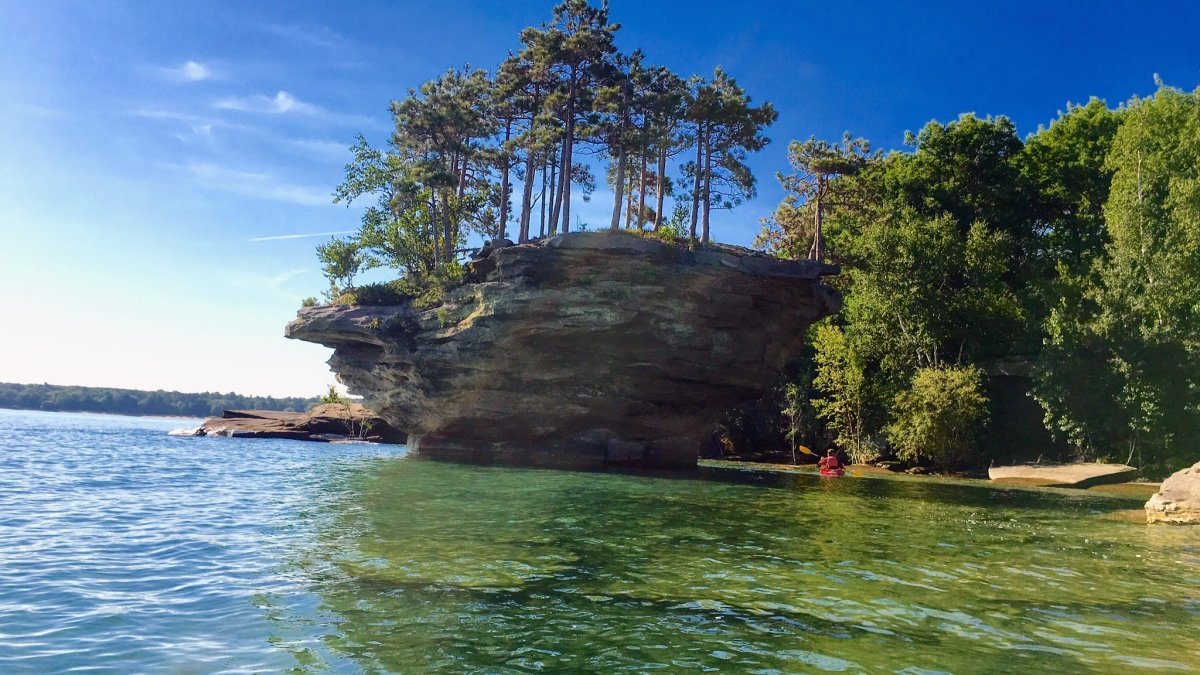
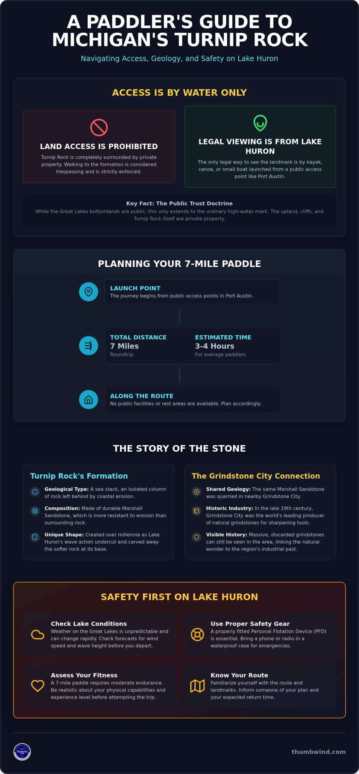
A trip to see Turnip Rock in Michigan requires more than just a GPS destination. The iconic formation, located off the shore of Port Austin at the tip of Huron County, is completely surrounded by private land, making it inaccessible by foot. The only legal way to view this natural landmark is from the water, necessitating a 7-mile round-trip kayak or small boat journey on Lake Huron.
This guide provides the necessary details for planning a safe and legal trip. It covers the history of the private property that makes land access impossible, the geological forces that shaped the rock, and the specific safety precautions required for navigating the unpredictable waters of the Great Lakes. Understanding these elements is essential for a successful visit.
Understanding Access to Turnip Rock and the Pointe Aux Barques Shoreline
Turnip Rock is a small, distinctively shaped sea stack located in Lake Huron, just off a point of land near Port Austin. The unusual formation is the result of centuries of wave action eroding the softer rock at its base, leaving a narrow pedestal supporting a larger, tree-topped cap. While visually appealing, its location presents a significant access challenge for visitors.
- Turnip Rock is a geological stack formation situated at the tip of Michigan’s Thumb in Huron County.
- The land surrounding the rock is privately owned by the Pointe Aux Barques Port Austin Association.
- Walking to the rock over land is strictly prohibited and enforced as trespassing.
- Legal access is only possible by water via Lake Huron, with most trips launching from Port Austin.
- While the rock becomes an island at high tide, any portion of it above the ordinary high-water mark is considered private property.
The Private Property Conflict at Thumbnail Point
The restrictions on land access stem from the history of the surrounding community. The Pointe Aux Barques cottage association was established in the late 1800s as an exclusive summer resort for wealthy families from Detroit and other Midwestern cities. Over the decades, the association acquired the land encompassing the shoreline, including the property adjacent to Turnip Rock.
Public access trails that once existed were closed in the mid-20th century as the community prioritized privacy and security for its residents. Legally, Michigan law establishes that the bottomlands of the Great Lakes are held in public trust. However, this public area only extends to the ordinary high-water mark. The upland, including the cliffs and the land Turnip Rock is attached to at low water levels, remains private property.
Why You Cannot See Turnip Rock from the Road
There are no public roads or overlooks that provide a view of Turnip Rock. The Pointe Aux Barques community is a gated enclave with private roads, and the dense woods and private holdings along the shoreline block any potential sightlines from public thoroughfares further inland. This arrangement means the only way to legally see the formation is from a boat or kayak on Lake Huron.
The secluded nature of the community has preserved the area’s natural state but also fuels the access debate. Visitors must respect the clearly marked boundaries to avoid trespassing violations. For more context on the area’s development, you can review the history of the Pointe Aux Barques community in 1900.
The Geology of the Huron Shoreline and the Grindstone Connection
The existence of Turnip Rock is a direct result of the unique geology of Michigan’s Thumb. The formation is composed of Marshall Sandstone, a durable rock that has withstood the relentless erosive power of Lake Huron better than the surrounding coastline. This resistance is what allowed it to become an isolated stack formation.
- Turnip Rock is made of Marshall Sandstone, which is more resistant to erosion than adjacent rock layers.
- Its distinctive "turnip" shape was created by wave action undercutting the softer rock at its base over thousands of years.
- The formation is capped with a layer of soil and small trees, whose root systems help stabilize the upper rock layer and slow erosion from above.
- The paddling route to the rock features other geological points of interest, including shallow sea caves and the nearby "Thumbnail Point."
Marshall Sandstone and the Grindstone City Industry
The same Marshall Sandstone that forms Turnip Rock was once the foundation of a major regional industry. Just a few miles down the coast lies the little town of Grindstone City, which was the world’s leading producer of natural grindstones in the late 19th century. The unique, abrasive quality of the sandstone made it ideal for sharpening tools.
Quarries in the area extracted massive stone wheels that were shipped globally. Today, visitors can see enormous, discarded grindstones scattered throughout the town and along the shore, serving as monuments to this bygone industrial era. The proximity of Turnip Rock to these historic ruins offers a direct connection between the region’s natural wonders and its industrial history. The local Grindstone Grill is a popular stop for those interested in this history.
Evolution of the Shoreline Over Centuries
The shoreline of Lake Huron is a dynamic environment, constantly being reshaped by natural forces. A stack formation, in geological terms, is a feature where a steep, vertical column of rock becomes isolated from a coastline by erosion. Turnip Rock is a classic example of this process in the Great Lakes.
Water levels in Lake Huron fluctuate significantly over decades, which directly impacts the rate of erosion. During periods of high water, wave action is more aggressive at the base of the cliffs and formations. In the winter, massive ice shoves can scour the shoreline, breaking apart weaker rock and further isolating durable stacks like Turnip Rock. These ongoing processes mean that the formation, while seemingly permanent, is slowly but continuously changing.
How to Plan Your 7-Mile Kayak Trip to Turnip Rock
The most common route to Turnip Rock is a 7-mile round-trip paddle that begins in downtown Port Austin. For most paddlers of average fitness and experience, this journey takes between three and four hours to complete, not including time spent at the destination. Proper planning is essential, as there are no facilities or public rest areas along the route.
- The standard paddle is a 7-mile round trip from Port Austin’s public launch sites. Bird Creek Park is an ideal starting point for most.
- The trip typically requires three to four hours of continuous paddling at a moderate pace.
- Launch fees and parking rules differ between the primary launch sites: Bird Creek Park and the Port Austin State Harbor.
- An alternative launch from Eagle Bay offers a slightly shorter route but is more exposed to open water conditions.
Choosing Your Launch Point in Port Austin
Paddlers have a few options for starting their trip, each with different logistics. The most popular is Bird Creek County Park, which offers a sandy beach launch, restrooms, and ample parking. The one-way paddle from here is approximately 3.5 miles. Be prepared for a launch fee, which is typically collected at the park entrance during peak season.
The Port Austin State Harbor is another option, better suited for those with their own larger boats. It has boat ramps and trailer parking but is a less convenient launch point for kayaks. A third choice is the Eagle Bay Public Access site, located east of Port Austin. This launch shortens the round trip to about 6.5 miles but features a rocky entry and is more exposed to wind and waves coming off Saginaw Bay.
The Paddling Route: What to See Along the Way
The journey from Port Austin to Turnip Rock offers several points of interest. As you leave the harbor, the Port Austin Reef Light is visible in the distance. This historic lighthouse sits on a shallow reef several miles offshore and marks a significant navigational hazard.
About two miles into the trip, you will encounter a series of shallow sea caves carved into the sandstone cliffs. These are best explored on calm days, as waves can make navigating near the rock walls difficult. Further along, you will pass other smaller formations, including one known locally as "The Fingernail," before the iconic shape of Turnip Rock comes into view.
Equipment and Preparation Checklist
A trip on Lake Huron requires proper safety gear, even on calm days. Weather conditions can change rapidly, and being prepared is critical. Do not attempt this trip in a recreational kayak designed for calm, inland lakes unless the marine forecast is exceptionally favorable.
- Required Gear: Every person must have a properly fitting PFD (Personal Flotation Device). Michigan law also requires a whistle or other sound-producing device. A dry bag is highly recommended for protecting electronics and spare clothing.
- Recommended Gear: For sit-in kayaks, a spray skirt is advised to keep water out of the cockpit on choppy days. Pack water, high-energy snacks, and sunscreen. The shoreline is known for its unique stones, making it a popular spot for enthusiasts interested in rock hunting on Michigan beaches.
Safety Requirements and Lake Huron Weather Thresholds
The single greatest risk when visiting Turnip Rock is the weather. Lake Huron is a vast body of water capable of producing dangerous conditions for small craft with little warning. Before launching, every paddler must check the marine forecast and be prepared to cancel their plans if conditions are unfavorable.
- Lake Huron’s weather can shift from calm to hazardous in a matter of minutes.
- Paddlers should cancel their trip if sustained winds exceed 10-12 knots or if waves are forecast to be over two feet.
- Offshore winds (blowing from the south or southwest) are particularly dangerous, as they can push kayakers away from the shore and make the return trip to Port Austin extremely difficult.
- The shoreline between Port Austin and Turnip Rock is almost entirely rocky cliffs, offering very few safe places to land in an emergency.
Monitoring Marine Forecasts and Webcams
A standard weather app is not sufficient for this trip. Paddlers should consult the NOAA Nearshore Marine Forecast for the Saginaw Bay to Port Austin area. This forecast provides specific information on wind speed and direction, wave height, and water temperature. Pay close attention to any small craft advisories.
Before leaving home, it is wise to check real-time conditions. A network of regional webcams in Michigan’s Thumb provides live views of the lake surface at Port Austin and other nearby locations. This visual confirmation can help you make a final decision on whether it is safe to launch.
Respecting the Environment and Leave No Trace
Visiting Turnip Rock comes with a responsibility to protect the fragile environment. The area is a natural landmark, not a developed park. Adhering to Leave No Trace principles ensures it remains preserved for future visitors. There are no trash cans or restrooms along the water trail; all waste must be packed out.
Climbing on Turnip Rock or the nearby sea caves is strictly prohibited. The sandstone is fragile and easily damaged, and the vegetation on top of the rock is a critical part of its structure. Disturbing the small trees and plants can accelerate erosion and destabilize the formation. Additionally, drone use should be respectful of the private residences nearby and avoid disturbing nesting birds.
Frequently Asked Questions About Visiting Turnip Rock Michigan
Can I walk to Turnip Rock during the winter when the lake is frozen?
No. Walking across the frozen lake is extremely dangerous and still constitutes trespassing. The ice conditions near the shore are unpredictable due to currents and pressure cracks. Furthermore, stepping onto the land or the rock itself remains a violation of private property rights, regardless of the season.
Is there a fee to visit Turnip Rock if I bring my own kayak?
There is no fee to view Turnip Rock itself from the water. However, you will likely encounter fees for parking and launching your kayak at public sites like Bird Creek County Park. These fees support the maintenance of the park facilities. Launching from the State Harbor may also require a Michigan Recreation Passport.
Are dogs allowed in kayaks for the Turnip Rock trail?
While many kayaks can accommodate a dog, this 7-mile open-water trip is not recommended for pets. There are no places for a dog to get out, stretch, or relieve itself along the route. The journey can be long and stressful for an animal, and an agitated dog could compromise the stability of the kayak.
What happens if I get stranded on the private property near Turnip Rock?
If a true emergency, such as a sudden storm or medical issue, forces you to land on the private shoreline, your immediate safety is the priority. However, you should contact emergency services (911) or the Huron County Sheriff’s Office to report your situation. Landing for non-emergency reasons is trespassing and may result in a citation or a request to leave from property owners or local law enforcement.
Is Turnip Rock accessible by motorized boat or pontoon?
Yes, motorized boats can be used to visit Turnip Rock. However, the area immediately around the rock is very shallow and filled with submerged rock hazards. Boaters must approach with extreme caution and at low speed. It is not possible to beach a pontoon or larger boat on the shore due to the private property restrictions and rocky terrain.
What is the best time of day to paddle to Turnip Rock for photography?
For photography, the best light typically occurs during the "golden hours" of early morning and late afternoon. An early morning paddle often provides calmer water and soft, easterly light that illuminates the face of the rock. A late afternoon trip offers warm, dramatic lighting as the sun gets lower in the west, but be mindful of paddling back after sunset.
Disclaimer
Information published on Thumbwind.com is provided for general informational purposes. While we make reasonable efforts to keep articles accurate and current, details such as prices, hours, regulations, access conditions, and other information may change without notice. Readers should verify important details with the appropriate business, agency or official source before making travel, financial or other decisions. Thumbwind.com is not responsible for the content, availability or practices of third-party websites linked from our articles.