by
by 
Mostly mild today across Michigan, but prepare for rain and potential storms by week’s end.
All regions of Michigan will see increased clouds and rising rain chances through Friday, with cooler temperatures settling in this weekend.
Warming Temperatures and Mild Conditions Lead Off Midweek Forecast
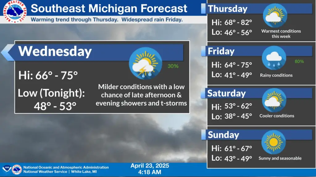
Southeast Michigan residents woke to a mostly sunny Wednesday with highs reaching near 72°F. A slight chance of showers and thunderstorms may develop by mid-afternoon, though the odds remain low at 20%. Winds will be light and variable. Tonight brings increased clouds and a 30% chance of rain, with lows around 52°F.
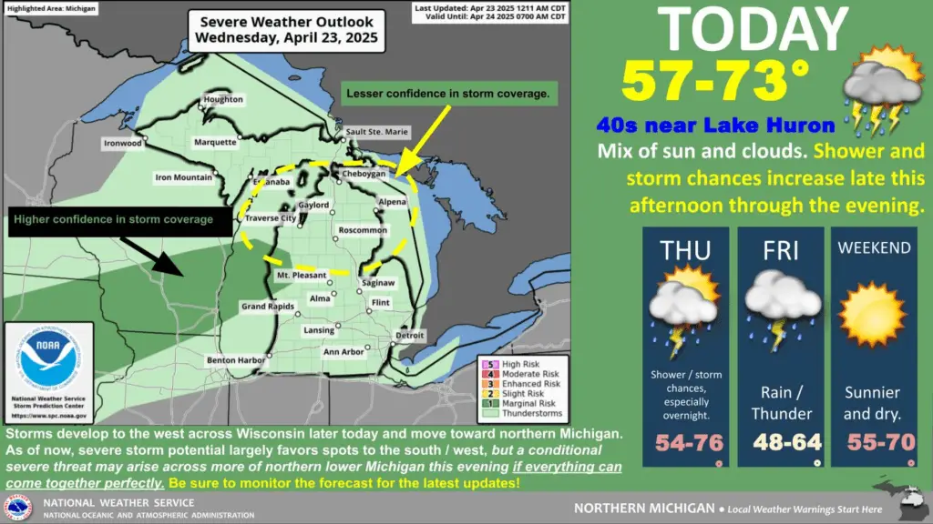
Further north in Gaylord and the northern Lower Peninsula, highs will top out near 68°F, though clouds will build during the day. A 30% chance of showers kicks in after 2 p.m., increasing to 50% overnight with possible thunderstorm activity and a low around 46°F.
In Michigan’s Upper Peninsula, residents near Kiva will also see clouds increase throughout the day, with a slight 20% chance of afternoon showers and highs near 62°F. Showers and isolated thunderstorms may pass through this evening before tapering off around midnight. Lows will fall to around 38°F.
Friday Brings Widespread Rain, Thunderstorm Risk for All Regions
Rain is expected to become more persistent and widespread across Michigan beginning Friday, with the heaviest activity likely in the afternoon.
In Southeast Michigan, rain and possible thunderstorms are forecast after 2 p.m. with an 80% chance of precipitation and gusts up to 18 mph. Rainfall totals may reach up to half an inch. The storm threat will continue into Friday night before tapering to scattered showers.
Northern Lower Michigan can also expect rain through the day, starting mid-morning and continuing into the evening, with the NWS predicting 80% coverage. Winds from the east at 10 mph will shift as the system passes. Temperatures will peak near 55°F and drop to the mid-30s overnight.
The Upper Peninsula will also be impacted Friday, with showers likely before 2 p.m., then easing slightly into the evening. Gusty north winds up to 20 mph and a daytime high of only 43°F will make for a chilly, wet day. Rain chances remain high at 70%, with overnight lows dipping to 34°F.
Weekend Weather Cools Down but Clears Up
The outlook improves heading into the weekend, though temperatures will be lower than average for late April.
By Saturday, skies are expected to begin clearing:
- Southeast Michigan: Gradually clearing skies with highs near 56°F.
- Gaylord region: Mostly sunny, with highs also near 56°F.
- Upper Peninsula: Sunny and crisp, with highs near 53°F.
Sunday continues this trend with sunshine returning statewide and temperatures rebounding slightly:
- Southeast: High near 65°F.
- Northern Lower Peninsula: High around 67°F.
- Upper Peninsula: High around 60°F.
Hazardous Weather Changes Fast – Stay Updated
Weather Watches, Warnings, and Advisories are frequently updated by the NWS.
Please look for updates to this report from the National Weather Service, your local news channels, and NOAA All Hazards radio.
Please follow ThumbWind Publications for more local weather and news updates. Your helpful comments are welcome.
More Weather Stories
14 Areas Around the Great Lakes With Significant Lake Effect Snow – How Does it Happen
Review the snowbelt hotspots and the science behind Lake Effect Snow.
4 Live Venice Florida Webcams, Latest Venice News & Weather Updates
See live beach conditions, weather, and traffic in Venice, Florida.
Great Lakes Ice Coverage
Track ice coverage trends over the Great Lakes and understand their role in regional weather.