by
by 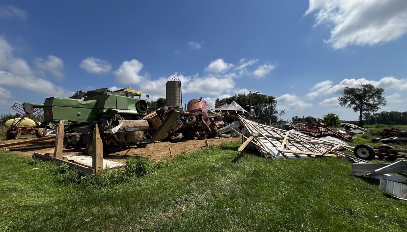
An EF-1 tornado struck rural Sanilac County near Deckerville on July 26, damaging crops, buildings, and vehicles in a brief but powerful afternoon storm.
Weak Supercells Spawn Unexpected Deckerville Tornado in Michigan’s Thumb
DECKERVILLE, Mich. — A brief but damaging EF-1 tornado touched down near Deckerville in Sanilac County on July 26, tearing through fields and damaging structures in a rare midsummer event fueled by subtle atmospheric instability along the Lake Huron shoreline.
According to a report from the National Weather Service (NWS) Detroit/Pontiac Office, the tornado developed just after 4:18 p.m. along a warm front near the M-46 corridor, a common hotspot for localized weather anomalies due to the interaction of inland and marine air masses.
While no injuries or fatalities were reported, the tornado carved a 1.58-mile path through farms and fields, reaching estimated wind speeds of 95 mph and a maximum width of 100 yards before dissipating three minutes later.
Tornado Tracked Through Fields, Damaging Crops and Equipment
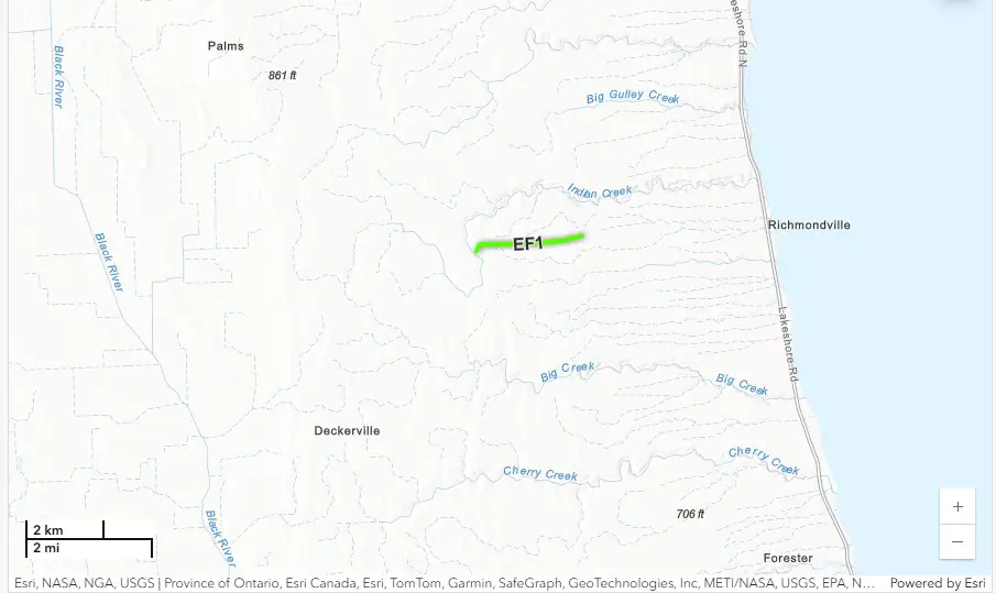
The tornado first touched down near Maple Grove and Richmondville Roads, at the edge of a sugar beet and corn field. The storm uprooted trees and snapped large limbs, some of which were carried nearly 100 yards.
In a particularly dramatic moment, the top of a large pine tree was torn off and impaled a semi-truck parked nearby. Multiple vehicles, including a camper, were lifted and rotated. A large farm building lost sections of its back wall and roof, with debris found up to 1,000 yards away in a nearby wheat field.
Damage assessments also documented a convergent path of flattened corn, a clear indicator of tornado-force winds. The tornado continued through open farmland, where it damaged sugar beet crops, destroyed outbuildings, and tossed debris across Loree Road before lifting near Richmondville Road.
Meteorological Setup Produced a Low-Probability Event
Forecast models had suggested low tornado potential across southeast Michigan on July 26 due to weak upper-level winds and minimal instability. However, meteorologists from the NWS noted that a marine-layer-enhanced warm front near Lake Huron created just enough localized wind shear to enable tornadogenesis.
Radar scans were hindered by elevation limits — with the nearest readings at 4,700 to 6,100 feet above ground level — making real-time detection and confirmation more difficult. Even the supercell responsible for the tornado showed minimal lightning activity, highlighting the subtlety of the storm’s development.
Tornado Unusual but Not Unprecedented for Thumb Region

This event mirrors past tornado developments along Michigan’s shoreline zones. According to NWS meteorologists, the interaction between southeast winds and lake-influenced boundaries has produced similar events near Detroit Beach and Luna Pier in the past.
In a statement following the damage survey, NWS Detroit/Pontiac thanked Sanilac County Emergency Management for its assistance in ground-level documentation and coordination.
While tornadoes are not uncommon in Michigan, mid-summer tornadoes in the Thumb with low radar signatures and minimal storm lightning remain rare. The storm highlights the unpredictable nature of mesoscale weather phenomena in agricultural areas along the Lake Huron shoreline.
Damage Clean-Up Underway as Crops, Property Owners Take Stock
Local farm operators are beginning the clean-up and assessment process. Damage to corn and sugar beet crops is still being calculated, and aerial imagery provided by the Michigan State Police is helping landowners and emergency responders visualize the full extent of the tornado’s path.
No federal or state disaster declarations have been made as of July 29, but agricultural losses may be eligible for insurance compensation or disaster relief depending on crop damage evaluations and equipment loss.
Read More Interesting Feature Stories From ThumbWind
- Michigan Feature News Stories – Unveiling the diverse and vibrant people, captivating places, and remarkable events that come together to make the Great Lake State unique.
- Strange Political News – A sarcastic take on official news from around the U.S., exploring the absurdities that often arise in the political landscape while providing a humorous perspective on current events and highlighting the quirks of politicians and policies.
- Michigan Hometown News – News and events from Michigan’s Upper Thumb region worth knowing, including local stories, impactful interviews, and updates on community happenings that shape the culture and lifestyle of the area.
Your Turn – Like This, or Hate it – We Want To Hear From You
Please offer an insightful and thoughtful comment. We review each response. Follow us to have other feature stories fill up your email box, or check us out at ThumbWind News.