by
by 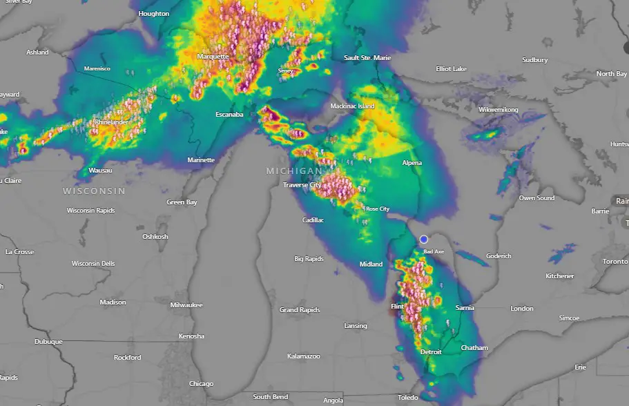
Michigan Heat advisory and storm warnings cover state as heat index tops 100°F. Severe weather and flash flooding possible through Tuesday across the state.
DETROIT — Issued by the National Weather Service at 6:54 AM EDT on June 21, 2025. From the U.P. to Metro Detroit, extreme heat and storms challenge Michiganders through early next week.
Scattered Storms and Dangerous Heat Impact All of Michigan
A prolonged heatwave and fast-moving storm systems are converging across Michigan, with residents from Detroit to Marquette facing sweltering conditions and the threat of severe thunderstorms. Heat Advisories are in effect throughout most of the state, and Extreme Heat Watches are posted through Tuesday.
Southeast Michigan Braces for Extreme Heat Through Tuesday
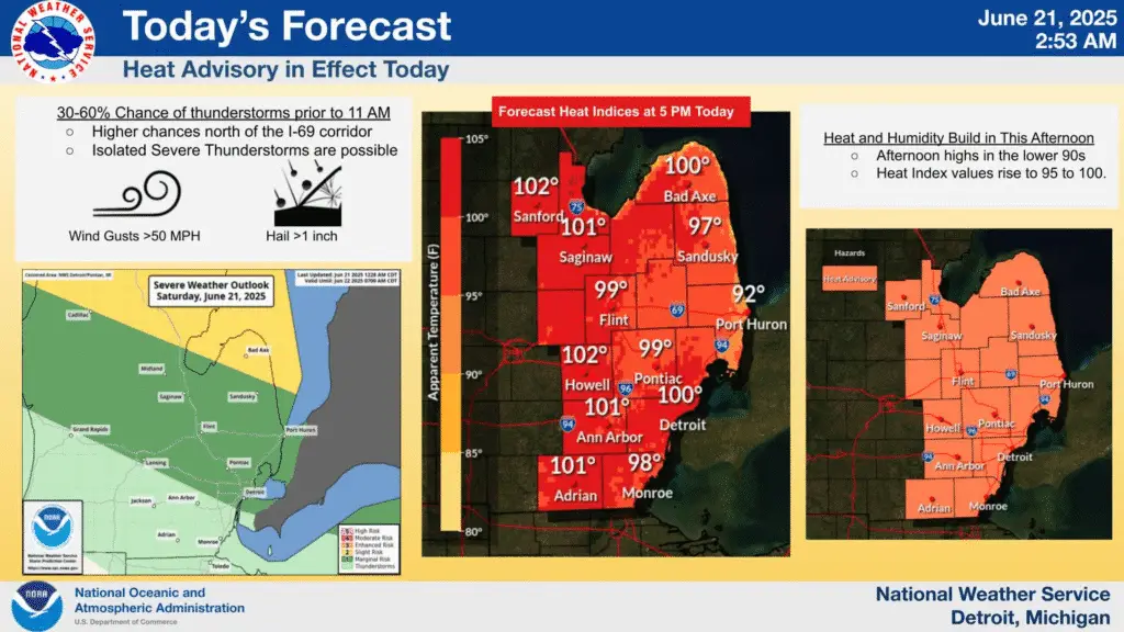
Scattered morning thunderstorms, some possibly severe, are sweeping through southeast Michigan, with gusts near 25 knots, large hail, and downpours expected. Thunderstorm activity should move out by midday.
Behind the storms, conditions rapidly shift to intense heat. Afternoon highs are projected to hit the mid-90s, with heat index values between 100 and 105°F, prompting a Heat Advisory for Detroit, Flint, and Saginaw through Sunday morning. Minimal nighttime cooling, with lows in the 70s, will extend heat-related health risks.
Thunderstorms are likely to return midweek. Forecast models suggest scattered systems from Tuesday through Friday, depending on the location of a stalled frontal boundary.
Record highs remain in play:
- Detroit: 98°F (1988)
- Flint: 96°F (1923)
- Saginaw: 94°F (1966)
Severe Thunderstorm Threat and Heat Blanket Northern Lower Michigan
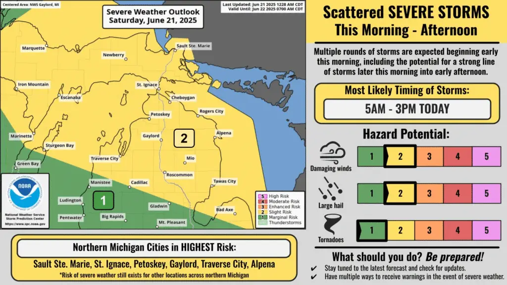
In Gaylord and northern Lower Michigan, a two-phase severe storm setup is underway. Initial thunderstorms this morning may bring damaging wind, hail, and an isolated tornado risk. After a brief clearing, a second round of storms is possible this afternoon and evening.
Temperatures across the region are forecast to climb into the 90s, with dewpoints near 70°F. This pushes heat index readings to near 100°F, especially inland. Heat Advisories remain in effect until 8 PM Sunday.
Winds are also a factor, with gusts up to 40 mph across open areas. LLWS (Low-Level Wind Shear) conditions are present today into Sunday morning.
Conditions ease slightly by midweek, but unsettled weather is expected to persist, with multiple rounds of storms and muggy air lingering through Friday.
Upper Peninsula Sees Morning Severe Storms and High Overnight Lows
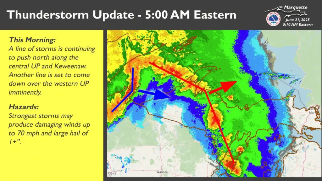
Thunderstorms arrived in the western Upper Peninsula before dawn. The Marquette NWS office confirmed storms with effective shear over 50 knots, raising the risk for 70+ mph wind gusts and hail exceeding 2 inches.
By noon, most thunderstorms are expected to clear eastward. But behind the storms, a hot and humid air mass will settle over the U.P. through Monday. Interior regions are expected to reach the low to mid-90s, with heat indices near 100°F.
Saturday night offers little relief—overnight lows may not fall below 70°F, particularly in inland valleys. Cloud cover from lingering convection will trap heat.
Sunday could set local heat index records in western and central counties. Heat Advisories have been issued for several counties, with additional alerts likely through Monday.
Forecast models suggest a cold front may arrive late Monday or early Tuesday, possibly sparking strong to severe storms again before cooling the region midweek.
Today’s Forecast Across Michigan
- Detroit: 95°F, Heat Index 102°F, morning storms tapering to hot sun
- Flint: 94°F, PM heat stress risk, minimal wind relief
- Saginaw: 92°F, breezy with possible isolated thunderstorm
- Gaylord: 91°F, storms early and possible again late
- Marquette: 87°F, morning severe risk, warm and muggy through evening
Hazardous Weather Changes Fast – Stay Updated
Weather Watches, Warnings, and Advisories are frequently updated by the NWS.
Please look for updates to this report from the National Weather Service, your local news channels, and NOAA All Hazards radio.
Please follow ThumbWind Publications for more local weather and news updates. Your helpful comments are welcome.
More Weather Stories
14 Areas Around the Great Lakes With Significant Lake Effect Snow – How Does it Happen
A region-by-region breakdown of where and why heavy snow hits hardest in the Great Lakes.
4 Live Venice Florida Webcams, Latest Venice News & Weather Updates
Live beach views, weather data, and crowd updates from Florida’s Gulf Coast.
Great Lakes Ice Coverage
Track real-time and historical ice coverage data from NOAA and Environment Canada.