by
by 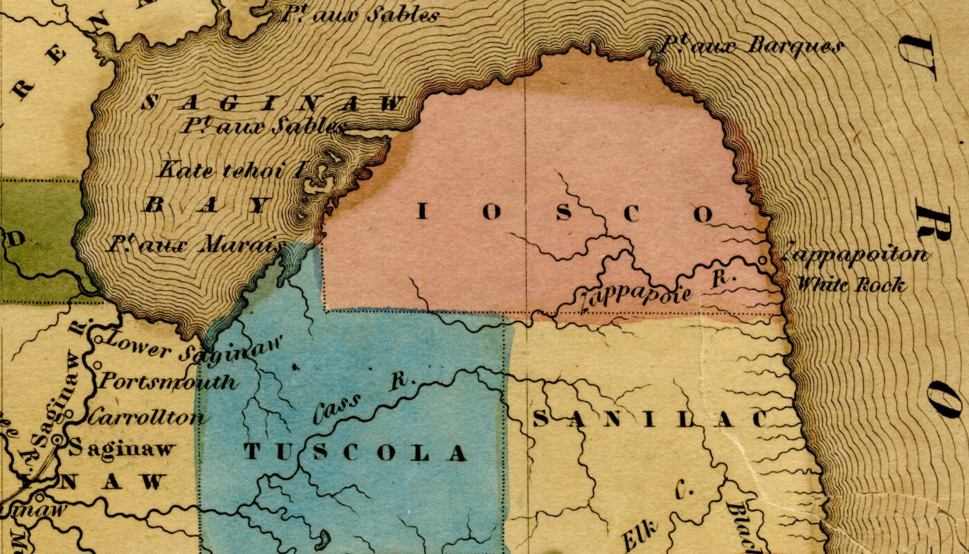
White Rock Michigan History isn’t just about a shoreline landmark—it’s also a case of shifting names on early maps. In 1842, cartographers labeled a village called “Zappapoiton” and a stream called the “Zappapoie River” at today’s White Rock on Lake Huron. The creek is now known as Elm Creek, also called White Rock Creek. The village name faded from later atlases. This post reviews what the records show, why the spellings likely changed, and how White Rock Michigan History helps explain the mix of Indigenous, French, and surveyor terms that once marked this coast.
Where the names appear
An 1842 map shows Zappapoiton on the shore and Zappapoie River entering Lake Huron at the site known today as White Rock. The stream is now mapped as Elm Creek—also called White Rock Creek—and the settlement label faded from later atlases. This case study adds a clear entry in White Rock Michigan history.
The H.S. Tanner 1842 map places “Zappapoiton” at the lakeshore with “Zappapoie R.” just south of it. Period guides list Zappapoie as a principal stream for the county, then shown on the map, matching the modern creek mouth at White Rock.
In the publication The Western Tourist; or, Emigrant’s Guide through the States of Ohio, Michigan, Indiana, Illinois, and Missouri, and the Territories of Wisconsin and Iowa: Being an Accurate and Concise Description of Each State, Territory, and County. New York: J. H. Colton, 1846. Future Huron County is called Iosco. Co. contains about 800 square miles ; bound-ed northwesterly by Saginaw bay, and northeaster-ly by Lake Huron. Zappapoie and Black riversare the principal streams,
What Zappapoie is today.
Field references and modern maps indicate that Elm Creek at White Rock is the same feature once labeled as Zappapoie River. Archival captions also mention “Shale Creek,” a local descriptive term for the same outlet.
Why the names changed
As surveyors standardized spelling and county lines settled, unique phonetic renderings—often attempts to capture Indigenous or French names—were dropped. White Rock remained the anchor term due to its role as a shoreline landmark tied to early treaty boundaries.
What Zappapoiton likely meant
The village label signals an Indigenous locality or camp near White Rock recorded by a few mid-19th-century mapmakers. No later gazetteer shows a continuing town under that spelling, which suggests the name was temporary or poorly standardized.
It may be a phonetic rendering of an Anishinaabemowin place name ending in -ong (“at/in a place”), marking a camp or village at the creek mouth by White Rock.
“Zappapoie” could reflect a mapmaker’s attempt at a term for a small river or outlet, akin to Ojibwe roots like ziibi/ziibiins (“river/creek”).
Another possibility is that “Zappapoiton” preserves a personal or clan name followed by a place marker, filtered through French-style spelling and then anglicized on the 1842 pla
How to see the site now
The outlet of Elm Creek meets Lake Huron at White Rock in Huron County, near M-25. A roadside stop offers views of the shore and the creek mouth where the 1842 map placed Zappapoie River. The shoreline setting explains why early cartographers clustered labels at this point.
These fragments—Zappapoiton and Zappapoie—don’t survive on modern signs, but they still mark the spot where a small stream, a lakeshore landmark, and a brief chapter in naming practices meet.
Modern Huron County Was Created as Huron in 1840, Not Renamed From Iosco
Was Huron County Named Iscoco?
The legislative record does not show that the area now called Huron County was ever officially renamed from Iosco County. Instead, it shows that Huron County was created under the name Huron on April 1, 1840, by Act No. 119, section 32, in the act titled “An act to lay off and define the boundaries of certain counties.”
The same record shows that Iosco was a different county altogether: it was created on the same day as Kanotin County and then renamed Iosco on March 8, 1843, by Act No. 67, page 145, in “An act to change the names of certain counties.” In short, the 1842 map label “Iosco” on the Thumb does not match the enacted law for that territory.
The legal history after 1840 is administrative, not nominal. Huron was attached in turn to Saginaw, St. Clair, Sanilac, and partly to Tuscola for judicial or representative purposes, and then was organized by Act No. 6 on January 25, 1859. That 1859 act, however, also delayed the election of Huron’s own county officers until November 1860 and kept Sanilac and Tuscola officers in place until Huron’s officers were elected and qualified. That is why some later county histories say “organized in 1860,” even though the organizing act itself was approved in 1859.
What the statutes say
The 1840 session laws are the starting point. A later documentary transcription of the 1840 act reproduces section 32 as making the Thumb-tip territory a “separate county” to be “the county of Huron,” and the Newberry county chronology identifies the same enactment as Mich. Acts 1840, annual session, no. 119, sections 32 and 34, page 200. The act title is given in a 1914 historical paper, quoting the session laws, as “An act to lay off and define the boundaries of certain counties.”
That same body of law shows that the county later known as Iosco was not in the Thumb. It was created on April 1, 1840 as Kanotin, described in section 14 of Act No. 119, and the Newberry chronology places it in the northeastern Lower Peninsula, not in Huron’s location. Then, on March 8, 1843, Act No. 67, page 145, changed Kanotin’s name to Iosco. The short operative wording in the transcription is that the name of Kanotin was “changed to that of Iosco.”
The result is straightforward: the statutory record contains one chain for Huron and another chain for Iosco. Huron’s chain begins as Huron in 1840 and stays Huron; Iosco’s chain begins as Kanotin in 1840 and becomes Iosco in 1843. I found no act between 1840 and 1859 that renames Huron to or from Iosco.
What changed between 1842 and Huron’s local organization
The changes affecting Huron after 1840 were attachments and local government steps, not name changes. The Newberry chronology shows this sequence: Huron was created from Sanilac and attached to Saginaw on April 1, 1840; detached from Saginaw and attached to St. Clair on March 11, 1844; detached from St. Clair and attached to Sanilac on April 1, 1850; had part of its territory detached from Sanilac and attached to Tuscola on Feb. 12, 1853; and then was fully organized on Jan. 25, 1859.
The 1859 organizing act is important because it explains the date issue. Section 1 says, in substance, that Huron “shall be organized.” Section 3 then sets the election of county officers for the general election in November 1860. Section 9 says Sanilac and Tuscola officers were to keep performing Huron-related duties until Huron’s own officers were elected and qualified. So the best reading is: legal organization act in 1859; practical transfer to Huron’s own officers after the 1860 election.
Map evidence and contemporary usage
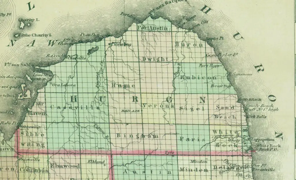
In the map excerpt you supplied, the Thumb-tip county is plainly labeled IOSCO, above TUSCOLA and SANILAC. That is real map evidence, but it is not consistent with the enacted county law already in force by 1840. The conflict is between a cartographic label and the statutory record, and on that question the statutes control.
Contemporary and near-contemporary printed sources line up with the statutes, not with the “Iosco in the Thumb” label. The says Huron County “was created by Michigan law on April 1, 1840” and “was fully organized by an Act of Legislature on January 25, 1859.” The has a separate entry for Huron County and describes it at the extremity of the peninsula formed by Saginaw Bay and Lake Huron. A contemporaneous newspaper item reprinted from the Grand Traverse Herald on Feb. 18, 1859 reported that “the bill to organize the county of Huron has passed both houses,” which fits the 1859 act.
Why the 1842 map shows Iosco
The exact reason this specific 1842 map places “Iosco” on the Thumb is unspecified in the sources I could verify. What the sources do show is that the label cannot be explained by a lawful rename of Huron County, because no such rename appears in the statutes. The safest conclusion is that the map reflects cartographic error, stale copied nomenclature, or other engraving confusion, not an official county-name change.
That reading fits the broader context. The 1840 act created many new paper counties in the northern Lower Peninsula, and the 1843 act renamed sixteen of them. A 1914 county-history paper on the name-change act noted that several unfamiliar county names were already being corrupted in print and suggested scribal or printer confusion as the cause. That evidence does not prove the exact mechanism for your map’s mislabeling, but it does show that early-1840s Michigan county names were sometimes copied badly even in legal and historical print.
Just as important, “provisional names” do not solve the Huron problem. Huron itself was already Huron in 1840. The provisional-name chain belongs to Iosco’s own county history: Kanotin in 1840, Iosco in 1843, in a different part of the state. So the 1842 Thumb label is not evidence that Huron once officially bore the name Iosco.
Final Thoughts
The evidence ties Zappapoiton and Zappapoie to the White Rock shoreline, even if the exact origin of the words remains unclear. Standardized mapping replaced those labels with White Rock and Elm Creek, but the geography—and the story—stayed put. White Rock Michigan History highlights how small features can carry big clues about settlement, treaty borders, and local usage. If new archival notes surface, we’ll update this report so readers have the clearest account of White Rock Michigan History available.