by
by 
The Michigan weather forecasts tell us to brace for frigid temperatures and snow showers as an Arctic air mass descends, bringing hazardous conditions statewide.
Arctic Air Mass Brings Frigid Conditions Across Michigan
Michigan is experiencing a significant drop in temperatures as an Arctic air mass settles over the region. Residents across the state should prepare for frigid conditions and varying chances of snow showers.? Slick roads and visibilities below one half mile are possible at times. Exercise caution if traveling this morning and be prepared for rapidly changing conditions.
Southeast Michigan: Plummeting Temperatures and Wind Chills
DETROIT — Issued by the National Weather Service at 3:44 AM EST on March 1, 2025.
Frigid Temperatures and Gusty Winds Grip Southeast Michigan
An Arctic air mass has settled over Southeast Michigan, leading to a significant drop in temperatures and gusty winds. Residents should prepare for frigid conditions and low wind chills.?
- Temperatures: Highs today will struggle to reach the mid-20s°F, with lows dipping into the teens°F overnight.?
- Wind Chills: Gusty northwest winds will result in wind chills near or below zero°F at times.?
- Precipitation: A chance of light snow showers exists, but significant accumulations are not expected.?
These conditions are expected to persist through the weekend, with only slight moderation in temperatures by Sunday.?
Southwest Michigan: Lake-Effect Snow Showers and Hazardous Travel
GRAND RAPIDS — Issued by the National Weather Service at 3:10 AM EST on March 1, 2025.
Lake-Effect Snow Showers and Hazardous Travel Expected in Southwest Michigan
Southwest Michigan is under the influence of an Arctic air mass, resulting in lake-effect snow showers and hazardous travel conditions. Residents should exercise caution on the roads.?
- Snow Showers: Lake-effect snow is expected, with accumulations of 1-2 inches possible, especially west of US-131.?
- Temperatures: Highs will be in the upper teens°F to low 20s°F, with lows in the single digits°F overnight.?
- Wind: Breezy conditions with northwest winds may cause blowing and drifting snow, reducing visibility.?
These conditions are expected to persist through Saturday morning, with gradual improvement by Sunday.?
Northern Lower Michigan: Snow Showers and Cold Temperatures
GAYLORD — Issued by the National Weather Service at 3:53 AM EST on March 1, 2025.
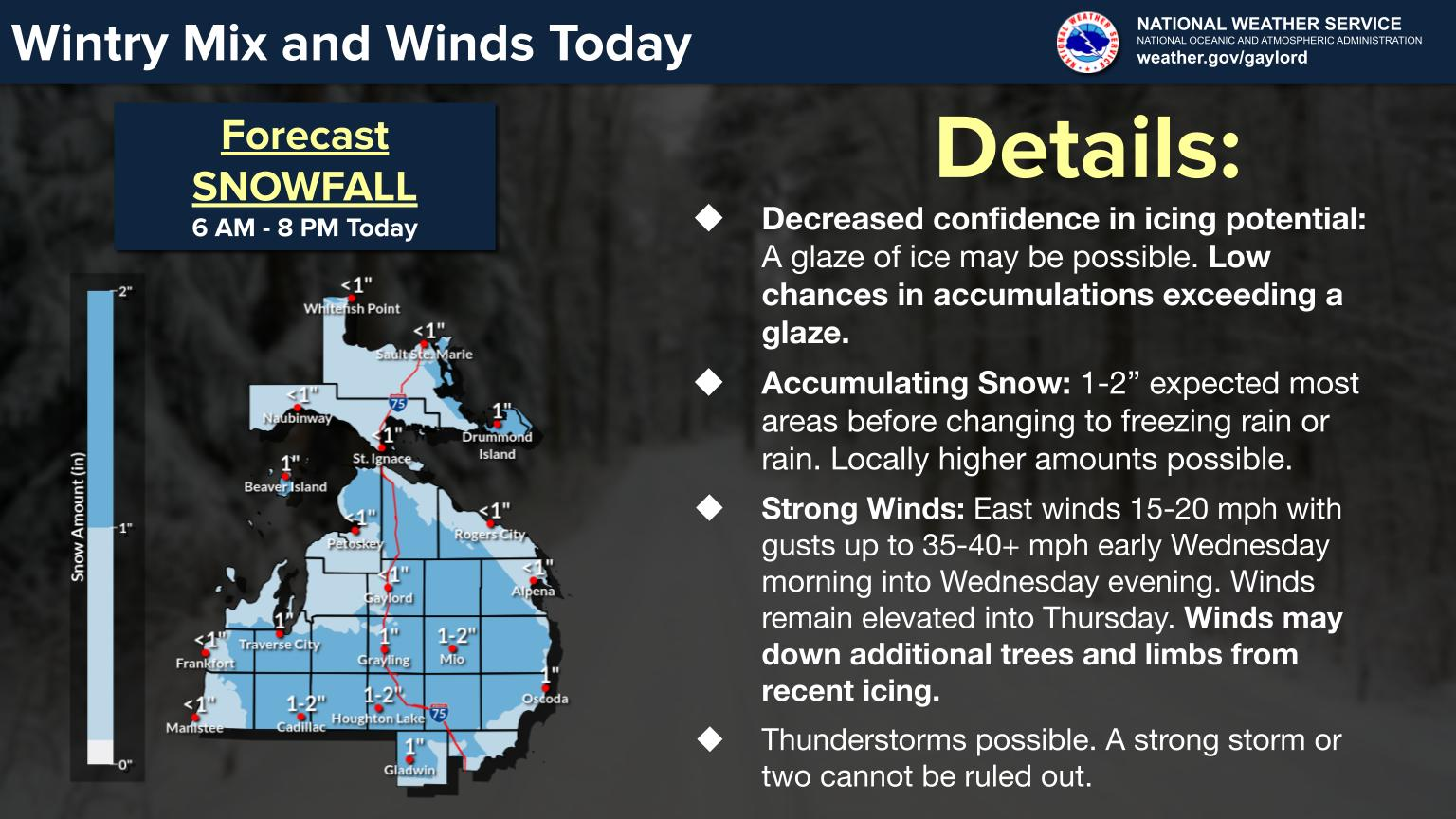
Snow Showers and Cold Temperatures Continue in Northern Lower Michigan
Northern Lower Michigan is experiencing continued snow showers and cold temperatures due to the prevailing Arctic air mass. Residents should prepare for winter driving conditions.?
- Snow Showers: Ongoing snow showers are expected, with additional accumulations of 1-3 inches possible, particularly in the northwest snowbelt regions.?
- Temperatures: Daytime highs will be in the low 20s°F, with overnight lows in the teens°F.?
- Wind: Northwest winds will continue, leading to areas of blowing and drifting snow.?
These conditions are expected to persist through Saturday night, with gradual improvement by Sunday.?
Upper Peninsula: Snow Showers and Frigid Temperatures
MARQUETTE — Issued by the National Weather Service at 3:19 AM EST on March 1, 2025.

Snow Showers and Frigid Temperatures Persist in the Upper Peninsula
The Upper Peninsula continues to experience snow showers and frigid temperatures as the Arctic air mass remains entrenched over the region. Residents should prepare for hazardous travel conditions.?
- Snow Showers: Moderate lake-effect snow showers are expected, with additional accumulations of 2-4 inches possible, especially in the eastern parts of the Upper Peninsula.?
- Temperatures: Highs will be in the mid-teens°F, with overnight lows dropping into the single digits°F.?
- Wind: Northwest winds will continue, leading to areas of blowing and drifting snow, reducing visibility.?
These conditions are expected to persist through Saturday night, with gradual improvement by Sunday.?
Hazardous Michigan Weather Forecast Can Change Fast – Stay Updated
Weather Watches, Warnings, and Advisories are frequently updated by the National Weather Service. Please look for updates to this report from the National Weather Service, or your local news channels