by
by 
Severe storms and heavy rain may impact northern and southeast Michigan today—tornadoes and flooding are possible. Stay weather-aware and monitor alerts.
Tornadoes, damaging winds, and flooding forecast for Michigan as heat wave builds for the weekend
GAYLORD — Issued by the National Weather Service at 1:35 a.m. on June 18, 2025.
Severe Storms Expected Across Southeast and Northern Michigan
A strong low-pressure system is moving through Michigan today, triggering widespread thunderstorms with damaging winds, localized flooding, and tornadoes possible across much of northern Lower Michigan and southeast Michigan. The National Weather Service (NWS) has issued warnings for both heavy rainfall and severe storm potential, as warm, moist air from the Gulf of Mexico fuels a volatile setup.
Northern Michigan Faces Heavy Rain and Possible Tornadoes
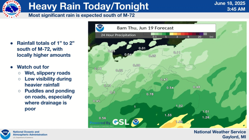
A stalled cold front and incoming shortwave from the Plains will bring elevated moisture levels and strong mid-level dynamics across northern Michigan, especially south of M-55, where training thunderstorms could drop more than 1 inch of rain in a short time. The Storm Prediction Center has placed parts of Gladwin County under a slight risk for severe weather.
According to the NWS Gaylord office, precipitable water values exceeding 1.5 inches, deep vertical lift, and frontogenetic forcing could lead to efficient rain-producing thunderstorms. The severe threat depends on how far north warm, unstable air can reach.
While most storms are expected to remain elevated, any surface-based activity will be capable of producing damaging winds and possibly tornadoes. Residents in Grayling, Gaylord, and Houghton Lake should remain alert.
Upper Peninsula Remains on the Fringe of the Main Threat
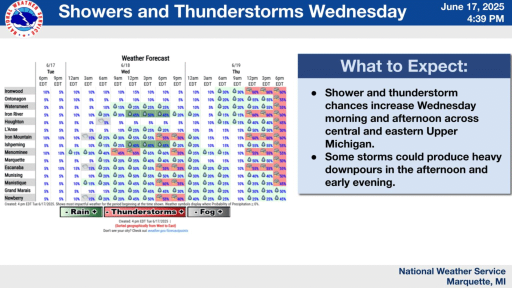
The Upper Peninsula will largely avoid the worst impacts. According to the NWS office in Marquette, only scattered showers and isolated storms are expected over central and eastern areas. Severe weather is not expected due to a lack of wind shear.
However, a humid air mass is firmly in place and will contribute to daily thunderstorm chances through the weekend, especially Thursday and beyond. Temperatures are projected to rise significantly by Sunday, with heat indices potentially reaching 100°F.
Southeast Michigan Under Enhanced Risk for Tornadoes, Wind Gusts
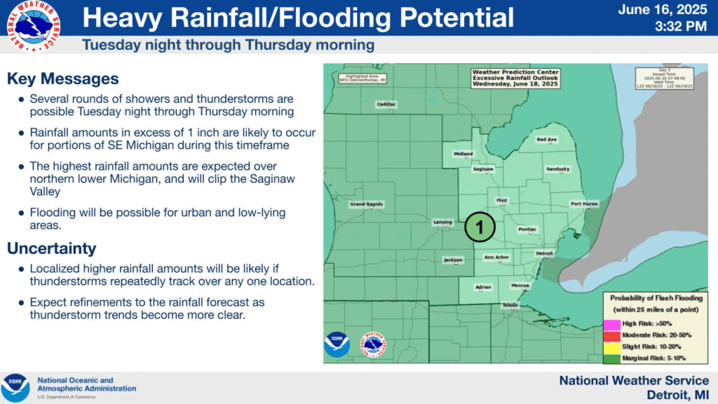
Detroit, Flint, Saginaw, and surrounding areas face a higher risk today as surface-based storms develop in advance of a deepening low. The NWS Detroit/Pontiac office noted that a strong low-level jet, increased CAPE values, and deep-layer shear support organized thunderstorm development, including possible supercells and embedded tornadoes.
Forecast soundings show streamwise vorticity and favorable low-level helicity, especially near frontal boundaries north of I-69. An incoming mesoscale convective system (MCS) may bring wind gusts exceeding 70 mph later this evening, with isolated hail up to one inch.
A secondary concern is flooding, as training convection may lead to 1.5 to 3 inches of rain, especially across the Tri-Cities and northern Thumb. Areas such as Bay City, Midland, and Port Huron are at highest risk.
Major Heat Wave Expected This Weekend Into Next Week
Beyond today’s storm threat, all three regions — Northern Lower, Upper Peninsula, and Southeast Michigan — are bracing for a significant heat wave starting Saturday and lasting into early next week.
Forecast models suggest temperatures in the upper 80s to low 90s, with dew points in the 60s to low 70s. Combined, this could lead to heat index values near or above 100°F. The NWS warns that residents without air conditioning or adequate hydration should begin making preparations now.
The Upper Peninsula may see 100°F highs in localized downsloped areas by Sunday, while southeast and northern Lower Michigan will contend with oppressive humidity and continued storm chances each afternoon.
Today’s Forecast Across Michigan
- Southeast Michigan: Scattered storms this morning with severe storms likely in the afternoon and evening. Highs in the mid-80s. Damaging winds and tornadoes possible.
- Northern Lower Michigan: Storms developing by midday. Heavy rainfall south of M-55. Slight tornado risk. Highs in the upper 70s.
- Upper Peninsula: Isolated storms in the central and eastern U.P. Mostly cloudy with highs in the 70s. Severe weather not expected.
Hazardous Weather Changes Fast – Stay Updated
Weather Watches, Warnings, and Advisories are frequently updated by the National Weather Service. Please look for updates to this report from the NWS, your local news channels, and NOAA All Hazards radio.
Please follow ThumbWind Publications for more local weather and news updates. Your helpful comments are welcome.
More Weather Stories
14 Areas Around the Great Lakes With Significant Lake Effect Snow – How Does it Happen
A detailed look at Lake Effect Snow hotspots across the region.
4 Live Venice Florida Webcams, Latest Venice News & Weather Updates
Watch real-time conditions from the Gulf Coast’s most popular beach destination.
Great Lakes Ice Coverage
Tracking regional weather trends and lake levels via live Great Lakes ice data.