by
by 
As October draws to a close, water levels across the Great Lakes basin are trending below long-term averages, with a forecast of further declines through November.
LANSING, MI – The U.S. Army Corps of Engineers reports that Great Lakes water levels are on a seasonal downward trajectory, with temperatures across the basin recorded 15 to 20 degrees Fahrenheit above average for the past week. Most lakes are experiencing levels several inches below those of last year, driven by persistent dry weather in the region.
Water Levels Dip Below Long-Term Averages
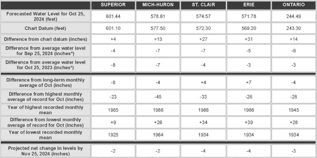
The latest report indicates that lakes Michigan-Huron, Superior, and Ontario are between 4 and 8 inches below their historical averages for October. In contrast, lakes Erie and St. Clair remain slightly above average, measuring 4 and 7 inches higher, respectively. The forecast projects further declines in water levels across all lakes by November 25, with Lake Superior and Michigan-Huron expected to drop by 2 inches and Lake Erie by 4 inches?.
The water level decline is partly attributed to lower-than-average precipitation across the basin, although the Lake Superior area did receive about 0.5 inches of rain. Despite predictions for wet conditions over the weekend, drier weather is anticipated to return early next week, with intermittent rainfall expected mid-to-late next week?.
Impact on Outflows and Navigation
Lake Superior’s outflow into the St. Marys River is forecast to remain below average for October, while outflows from Lake Erie through the Niagara River and Lake Ontario into the St. Lawrence River are expected to stay above average. Users along the waterways, including mariners, are advised to remain informed about fluctuating conditions, as water levels may vary at different locations due to meteorological factors?.
Seasonal declines, such as those forecast for November, are typical for the region, but ongoing high temperatures and reduced rainfall could impact waterway navigation and regional ecosystems. The Army Corps emphasizes the importance of staying updated through its water level data and navigational charts for those using the Great Lakes and connecting channels.
Find More Interesting Feature Stories From ThumbWind Publications
- Michigan Stories – Unveiling the people, places, and events that make the Great Lake State unique, we explore hidden gems and must-do activities.
- Weird Political News – A sarcastic and insightful take on official news released by government sources, PACs, and public officials across the U.S.
Your Turn – Like This, or Hate it – We Want To Hear From You
Please offer an insightful and thoughtful comment. Idiotic, profane, or threatening comments are eliminated without remorse. Consider sharing this story. Follow us to have other feature stories fill up your Newsbreak feed from ThumbWind Publications.