by
by 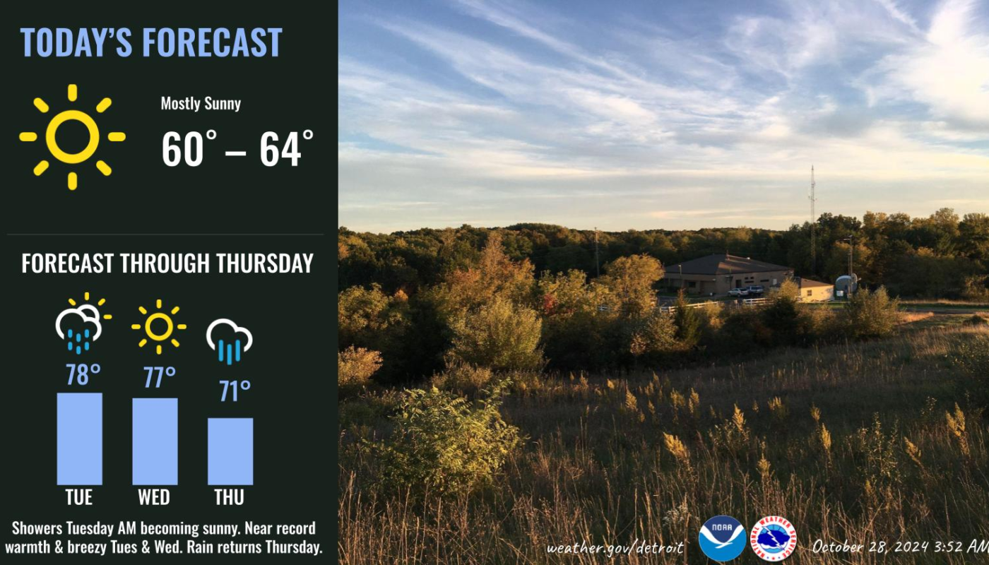
October heatwave to bring record highs to Detroit and surrounding areas before a cool front sweeps in Thursday.
Unseasonable Warm Spell Grips Southeast Michigan with Record-Breaking Potential
DETROIT — Issued by the National Weather Service at 3:57 AM on October 28, 2024.
Warm Weather and High Winds Expected Across Lower Michigan Midweek
Detroit and much of Southeast Michigan are bracing for a weather rollercoaster this week. The National Weather Service (NWS) reports that a surge of warm air will drive temperatures to the upper 70s, potentially breaking records on both Tuesday and Wednesday. A cold front is expected to bring rain and cooler temperatures by Thursday, ending the unseasonable warmth.
Temperatures May Shatter Records Across Southeast Michigan
After today’s mild high of around 64°F, Detroit, Flint, and Saginaw could experience record highs in the upper 70s over the next two days. Gusty southwest winds up to 30 mph will accompany these temperatures. The current temperature records at risk include:
- October 29th:
- Detroit: 77°F (1999)
- Flint: 75°F (1999)
- Saginaw: 72°F (1989)
- October 30th:
- Detroit: 76°F (1999)
- Flint: 77°F (1950)
- Saginaw: 76°F (1999)
Rain and Thunderstorms Expected Late Tonight into Tuesday Morning
The warm weather won’t arrive without complications. Showers and isolated thunderstorms could develop overnight into Tuesday morning as a warm front moves through the area. While storms are unlikely to be severe, gusty winds and lightning remain a possibility.
A cold front will follow Thursday, bringing cooler temperatures back to normal seasonal levels by Friday.
Hazardous Winds Over the Great Lakes – Gale Risk Possible
Mariners should be on high alert as strong southwest winds up to 35 knots are predicted Tuesday evening. Gale-force gusts may occur, particularly over Saginaw Bay and Central Lake Huron, despite warm air stabilizing low-level conditions. The southwest flow will persist until a cold front sweeps through Thursday, causing winds to shift northwest and bringing colder air by the evening.
Hazardous Weather Changes Fast – Stay Updated
Weather Watches, Warnings, and Advisories are frequently updated by the National Weather Service. Please look for updates to this report from your local news channels or NOAA All Hazards radio.
Follow ThumbWind Publications for more local weather and news updates.
Check Out Our Weather-Related Features
- Climate Twins – Countries with Weather Similar to Michigan
Curious about which places on Earth share Michigan’s unique weather patterns? Our latest article dives into Michigan’s Climate Twins, revealing surprising similarities and intriguing differences. - Live Webcams Of 7 Lake Effect Snow Cities Around The Great Lakes
Delve into the enchanting world of Lake Effect Snow in cities within the snow belt. Experience how urban landscapes transform into winter wonderlands with heavy snowfall. - 14 Areas Around the Great Lakes With Significant Lake Effect Snow – How Does it Happen
Lake effect snow from the Great Lakes occurs when conditions of evaporation and cold upper air currents slide over the region. Water retains heat more effectively than air, causing evaporation and creating snow when the warm, moist air cools as it rises.
Your Turn – Like This, or Hate It – We Want to Hear From You
Please offer an insightful and thoughtful comment. Idiotic, profane, or threatening comments are eliminated without remorse. Consider sharing this story. Follow us to have other feature stories fill up your Newsbreak feed from ThumbWind Publications.