by
by 
Author Note: I would love to stop at Michigan Historical Markers. I find myself driving out of my way to check a marker I recently discovered or have never seen before. I’m sure some of you have the same curious affliction. I was researching an upcoming post on Sleeper State Park and found this article from 2017 by the Michigan DNR. Sarah Lapshan wrote this showcase article from the Michigan Department of Natural Resources, and Tobi Voigt from the Michigan History Center. It introduces the Michigan Historical Marker Website, which I didn’t know until now. I hope you will find it as amazingly interesting as I did when looking for details about Michigan history.
What We Will Cover
50 Years of Michigan Historical Markers
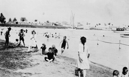
A single familiar green and gold sign on the M-109 loop runs between Empire and Glen Arbor in Leelanau County. It sits along the Lake Michigan shoreline – near an area once touted as the “Most Beautiful Place in America” by ABC’s “Good Morning America” show. This single sign marked the forward-thinking that recognized Michigan’s need for a statewide park system more than a century ago.
This appropriate sign remembers the creation of D.H. Day State Park, now part of the Sleeping Bear Dunes National Lakeshore, and Michigan’s post-World War I movement to preserve other scenic sites as public outdoor vacation destinations.
These green-and-gold signs, known as Michigan Historical Markers, appear on buildings and landscapes and serve to share fragments of Michigan’s rich history. Just about anyone who’s traveled the state’s roads and highways over the last 50 years likely has encountered a marker or two. It was all by design – as Michigan’s historical marker program is among the nation’s oldest.
The Start of the Michigan Memorial Program
The Michigan Legislature authorized the Michigan Historical Marker Program in 1955. Since that time, the program has reviewed and approved the placement of more than 1,700 markers throughout the state. Our unique Michigan-themed historical markers have been placed in other states, such as Kentucky’s Perryville Battlefield State Park, to denote the Michigan soldiers who aided the Union in this Civil War battle. In addition, a marker adorns the home of Antoine de la Mothe Cadillac, the French explorer who founded Detroit at Saint-Nicolas-de-la-Grave, France.
The historical markers are limited to tell a brief bit of history – as the text is limited to a few hundred words, it offers a glimpse of the importance of the place or even provides a high starting point to learn more.
Sandra Clark, director of the Michigan History Center, noted, “Michigan Historical Markers capture the stories of our state’s significant places, events and people in and around the locations where they happened or lived.” The Michigan History Center, an agency within the Michigan Department of Natural Resources, manages the marker program. The Michigan Historical Commission approves the application for the markers and their final text of the story on the Historical Marker.
At first, Michigan historical markers were placed at highway rest areas, state parks, scenic turnouts, and locations where past events occurred. That situation has changed. Historical monuments are found nearly everywhere, on the sides of buildings, in the front yards of residences and businesses, and even at notable schools.
Michigan’s earliest markers focused on European settlement, geology, unique geography, Native peoples, and military conflicts. Today, the program has been expanded to commemorate historically significant architecture, individual contributions, and other milestones.
Historical Markers Everywhere

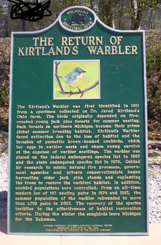
South of Grayling at a rest stop along Interstate 75, a Michigan Historical marker celebrates one of Michigan’s most exceptional wildlife restoration and conservation stories. The “Return of Kirtland’s Warbler” historical marker tells its readers that the bird nearly became extinct in the 1900s at the end of the states’ lumbering era as it and other industries altered the birds’ natural habitat. However, successfully restoring the bird’s habitat and conservation efforts saved the species. The marker reads, in part:
“… Guided by research to mimic natural fire processes, government agencies and private conservationists began harvesting older jack pine stands and replanting the trees to restore the warblers’ habitat. … From an all-time modern low of 167 nesting pairs in 1974 and 1987, the summer population of the warbler rebounded to more than 1,700 pairs in 2007. The recovery of the species testifies to the effectiveness of habitat restoration efforts. …”
“Return of Kirtland’s Warbler” historical marker
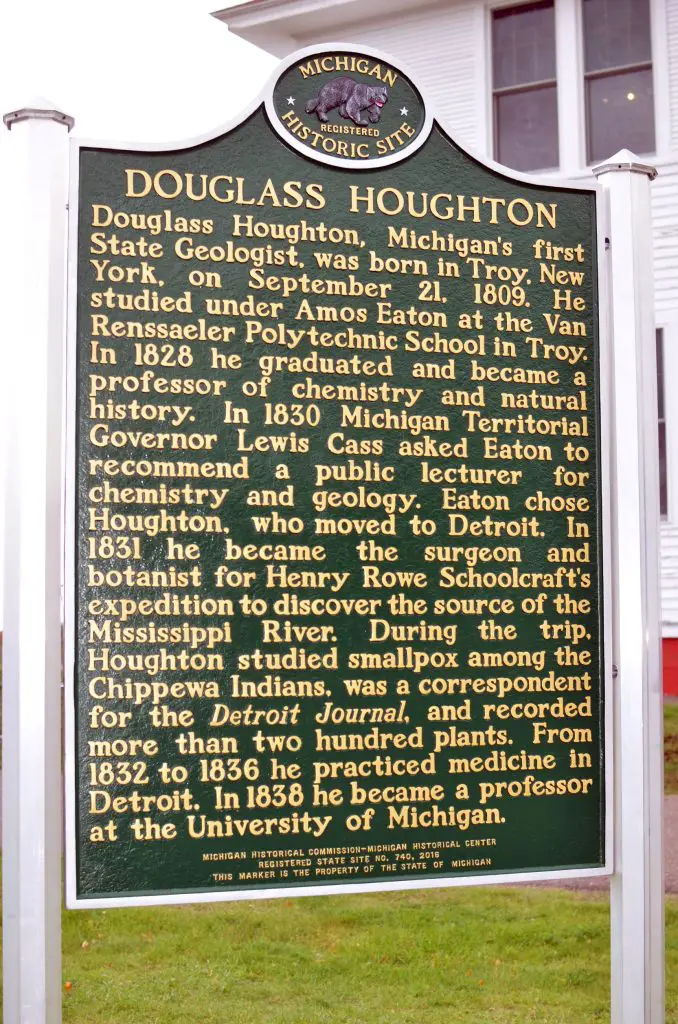
If you can travel to the Upper Peninsula, Keweenaw Peninsula can see the “Douglass Houghton” marker in Eagle River. This marker honors the man who served as Michigan’s first state geologist. An 1841 report from Houghton detailed his observations of the copper country area in the western U.P. This news sparked a new industry, and as a result, 1000s converged to the Keweenaw in search of their copper vein. The marker also gives credit to several of Houghton’s other contributions, including studying smallpox among the Chippewa Indians during his 1831 expedition with Henry Schoolcraft. In addition, his botanist efforts recorded more than 200 plant species and served as a correspondent for the Detroit Journal.
In July 2017, a marker was revealed that highlighted Detroit’s civil and racial unrest in 1967. The monument sits near where the rebellion and riot began, which is now the location of Detroit’s Gordon Park. It marked the 50th anniversary of the uprising. It sets the scene:

“In July 1967 the civil unrest that had been spreading across the United States reached Detroit. In the early morning hours of July 23, Detroit police officers raided a blind pig, an illegal after-hours bar, where patrons were celebrating the return of Vietnam War servicemen. …”
Markers now carry stories of historical points in time, milestones, and memories in Michigan history, making them compelling reading for both historians and citizens.
The Michigan Historical Markers Website

Those interested in learning the location of these markers had relied on private websites, books, lists, and many driving around. Finally, the DNR and the Michigan History Center staff put their heads together and strategized a solution to make it easier than ever for folks to find and learn about the markers and the history and stories to reveal.
The result; an interactive website Michigan Historical Markers, that can be accessed by smartphone, computer screen, or tablet – no particular app required.
“The Michigan Historical Commission originated and pushed for this project, and DNR technical and history staff made it happen,” said Clark. “We hope this historical marker database will pique the curiosity of Michiganders, help Michigan travelers better connect to the communities they visit, and inspire everyone to keep learning more about the real stories that make up Michigan’s fascinating past.”
Once on the website, visitors will find an interactive map that shows Michigan historical marker sites across the state. A search box at the top right corner of the map makes it possible for users to find markers near their homes, businesses, or vacation spots.
On the map, a small green icon represents each historical marker. When a visitor clicks on an image, a menu box with title and address information pops up. This dialog box includes clickable links that enable visitors to zoom in on the map, find more information about the marker, or get driving directions with Google maps.
The detail link provides specific information about the marker. This includes its location and installation dates, an image, and the marker text. Visitors also can download a printable copy of the marker information.
The Marker Site as a Research Tool

But the website is much more than just a map, said Mary Patrick, Michigan Historical Marker program coordinator. “This research tool is full of features that make it practical for students, researchers, trip planners, and other explorers to find historical marker information that will interest them,” she said.
For example, the filter feature (located below the map) enables visitors to pull map results by county, theme, or period. Clark said the theme filter is convenient for planning road trips around topics of interest.
“If someone is interested in the early auto industry, they can select that filter to find all the markers related to that topic and use the directions feature to plan the ultimate Michigan automobile road trip,” she noted. The website also includes the ability to customize the view. For example, visitors can switch the style of the map by clicking on different options – from the road to topographical – in the base maps feature.
The map defaults to showing only the markers. However, a user can also add state parks and campgrounds. In addition, Michigan’s network of rail trails is available, making it easy for families planning a Michigan vacation to plan a trip that incorporates visits to historical markers close to where they will be traveling.
The Michigan Historical Markers website was also built with researchers and technologists in mind. The map database is available on the main marker page as a free download (either as a KML or CSV file). It is made available as part of the DNR’s Open Data project, which provides accessible, high-quality information and analysis to drive informed decision-making.
Patrick said that although the marker website is live, there is still information to add, mainly photographs of all the markers. DNR staff are field testing and updating the database this fall, adding pictures and verifying the information.
Michigan History Center staff would also love to hear how others use the website.
“We encourage visitors who don’t see a marker in an exact GPS location to look around and see if it’s nearby,” Patrick said. “If they can’t find it, we hope they will let us know,” Patrick told the best way to share that information is by using the contact form link at the top of the marker website’s main page.
“Something is fitting and exciting about using the latest technology to help share the pieces of our past, making these important stories more accessible to more people,” said Clark. “As information is added or updated, it will be right at users’ fingertips – we’re putting history in your hands.”
What Types of Historical Markers Can Be Found in Michigan?
Michigan boasts a wide variety of historical markers that showcase its rich history. These include markers for historical homes, such as the Henry Ford Estate and the Dodge-Wilson House. Michigan also has markers indicating important industrial sites, like the Edison Illuminating Company’s Substation. Additionally, you’ll find markers for significant cultural and natural sites, such as the Detroit Opera House and the Isle Royale National Park. These markers are managed by the Michigan Historical Commission. (Source: Michigan.gov)
Related Michigan Historical Marker Reading
- Michigan’s M-25 Road Trip Around the Thumb
- Michigan’s Great Fire of 1881
- Marlette’s Beautifully Restored Train Depot
- The Jenks Michigan Roadside Park
- The Story of the Saginaw Trail
- The Amazing Lightship Huron
- The Archives of Michigan Offering Virtual Appointments