 by
by 
The Shore Indian trail was one of the five major routes of land travel leading out of Detroit. It was one of the best known to the early settlers. The trail begins from the rapids of the Maumee River to Toledo, then closely along the shore through Monroe and Brownstown to Detroit. From Detroit, it continues northward along the Detroit and St. Clair Rivers, past Fort Joseph (Fort Gratiot), and into the Thumb.
Table of Contents
The Debate – Did The Shore Trail Extend North Into the Thumb?
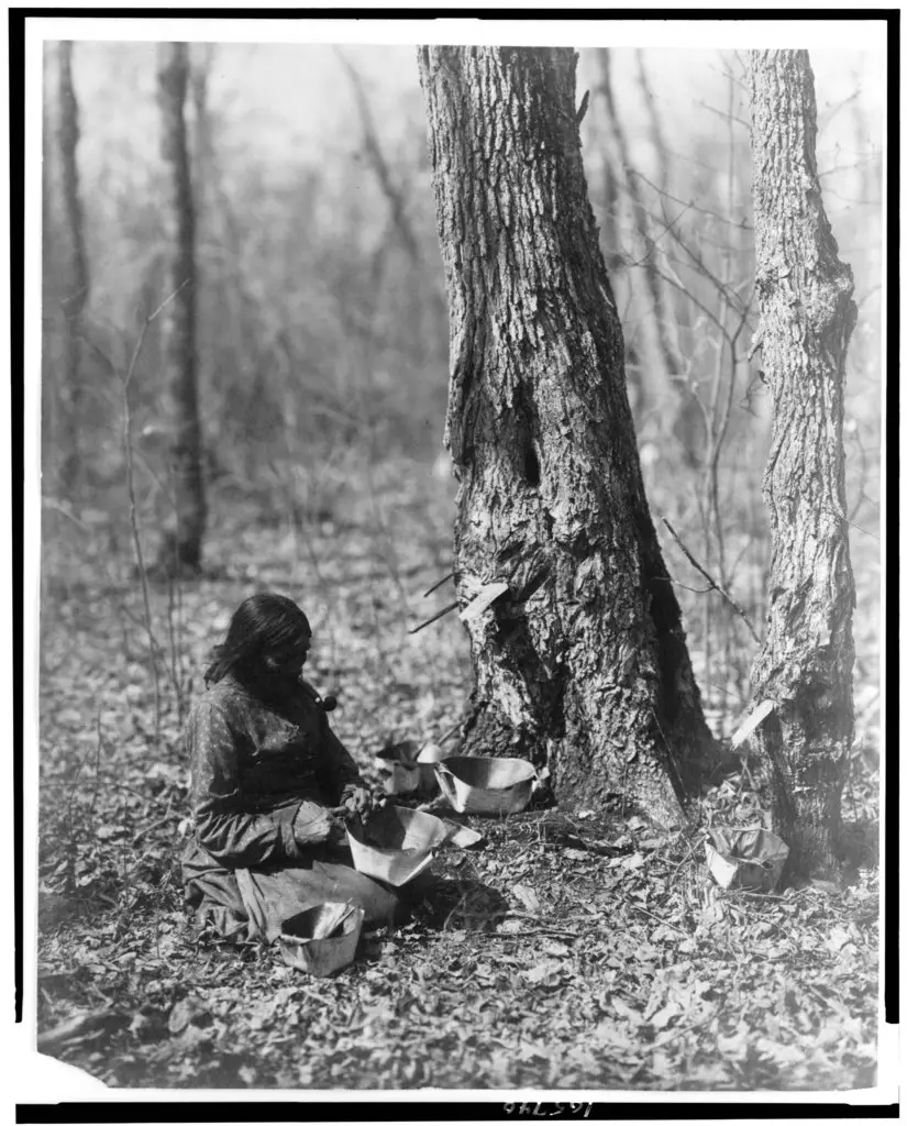
For over a thousand years, the Thumb region of Michigan served as a key seasonal hunting, fishing, and gathering site for indigenous tribes. These tribes, including the Anishinaabe and the Potawatomi, relied on the area’s rich resources for survival. They hunted deer, fished in the Great Lakes, and gathered wild berries and nuts. The location was also known for its maple trees. During the early spring, the trees were tapped, and sap boiled down to make maple sugar, an important food and trading item.
There is debate if the trail continues to the Native American landmark of White Rock, a spiritually significant site and the demarcation point for the 1807 Treaty of Detroit that was signed by the United States and the Ottawa, Chippewa, Wyandot, and Potawatomi Native American nations. Finally, the trail extends north to Pointe Aux Barques at the tip of Michigan’s Thumb.
Shore Indian Trail – Fort Miamis Trail – Hull’s Trace
This trail was considered part of the Great Trail, a network of footpaths created by Algonquian and Iroquoian-speaking indigenous peoples before the arrival of European colonists in North America. It connected the areas of New England, eastern Canada, the mid-Atlantic coast, and the Great Lakes region.
Hull’s Trace Map
[googlemaps https://www.google.com/maps/d/u/1/embed?mid=1XsLP098rXgJBbrX0nZxlyril1Jczobuh&&hl=en&msa=0&ie=UTF8&t=h&ll=43.802819,-84.924316&spn=5.550208,8.349609&z=6&output=embed&w=500&h=500]The southern portion of the Great Trail system began on the Atlantic coast in Delaware and continued through Pennsylvania, Maryland, and on to the Ohio River below present-day Pittsburgh. It continued west to Sandusky and beyond. The section of the Great Trail utilized by Colonial American troops during Pontiac’s Rebellion has been repaired and is now known as Highway US-23.
The Great Trail demonstrates that the original occupants traveled widely across the area, modifying it to fulfill their needs, similar to how Native Americans burned underbrush to clear the ground for planting crops and building deer pastures. These portions of North America were not an “untouched wilderness,” as early colonists claimed.
The Trails Role in the War of 1812
This trail became a crucial tactical element in the War of 1812. The young United States was concerned about supplying Fort Detroit, then in American hands, and the surrounding Michigan Territory. Since the British controlled Lake Erie, overland supply was the only option.
Starting in June 1812, troops under the command of General William Hull constructed what became known as “Hull’s Trace,” a 200-mile military road running from Urbana, Ohio, to Fort Detroit. 150 men under the command of Hubert Lacroix completed “Corduroy Road” on July 4, 1812, with the bridge over the River Huron.

The survey map above came from a research volunteer at River Raisin National Battlefield Park in Monroe. Rusty Davis found it while working on a research project and looking through the map card files at the Burton Historical Collection.
This is a draft map of Hull’s Road in Michigan, and it is surmised that this is the map McCloskey produced to fulfill the contract he was given after the lottery in December 1808. Because he turned this map in January, he must have just followed the existing trail, taking compass readings as he traveled. Somewhere around the Huron River, he may have deviated because Hubert Lacroix wrote in 1812 that he wasn’t able to find the slashes on the trees for the original route.
Hull’s Trace ran close to Lake Erie and the Detroit River, making it vulnerable to British attacks from the water. The first land-based skirmish of the war, the Battle of Brownstown, was fought on the road just north of this section. The later battles of Maguaga and Frenchtown were also fought along the trace. Hull’s Trace has been considered Michigan’s first road at the beginning of the settler era.
Michigan Historical Marker of Hull’s Trace
In April 1812, as the United States prepared for a possible war with Great Britain, Michigan’s Territorial Governor William Hull became the commander of the Army of the Northwest. His first task was to lead his army from Dayton, Ohio, to Detroit, building Hulls Trace, a two-hundred-mile-long road, as it marched. The army left Dayton on June 1. As it cut the trace through the wilderness from Urbana north, it laid logs crosswise across swampy areas to create a rough but stable corduroy roadbed that could support supply wagons. In late June, a detachment from Frenchtown commanded by Hubert Lacroix also worked on the road, attempting to follow a route laid out under an 1808 Territorial Legislative Council act. On June 18, 1812, the war was declared. Hull’s army arrived in Detroit on July 5.
Hulls Trace, which linked Detroit and Ohio, was to be the Michigan Territory’s inland lifeline during the War of 1812. However, the Detroit River and Lake Erie gave the British easy access to the Michigan portion of the road. American efforts to use the road to bring supplies and men from Frenchtown, present-day Monroe, were foiled twice before Hull surrendered Detroit on August 16, 1812. After the war, the Hulls Trace was used for ever-improving roads, beginning in 1817 with a new military road. In 2000 low water levels in the Huron River revealed a quarter-mile of the old corduroy road, lying three to six feet beneath Jefferson Avenue. Ax marks were visible on some of the logs. This rare example of a surviving corduroy road is listed in the National Register of Historic Places.
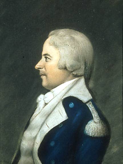
The Tragic Surrender of Detroit By General William Hull
On a foggy August morning during the War of 1812, infamous American General Willaim Hull made the most tragic decision of his life. Under a flag of truce, the British warned Hull that native forces under Shawnee Chef Tecumseh and Mohawk War Chief John Norton (Teyoninhokarawen) were about to lay siege on the Detroit Fort.
Advance on Fort Detroit
Native Warriors crossed the river and arrived south of the fort at Springwells the same night (Later named Fort Wayne). They then moved along the western edge of the woods, which bordered the farmlands below the Fort. The Confederation Warriors went unnoticed approximately a mile west of the beach as they surrounded the Fort. At the same time, British ships anchored in the river shelled the fort. The bombardment set parts of the fort on fire and killed a few civilians taking shelter. The Americans could not return fire.
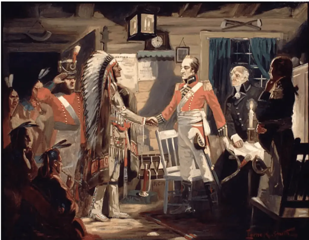
The following day, British General Isaac Brock crossed the Detroit River and led the British to arrive at Springwells unopposed. They marched north to May’s Creek and set up a defensive position along the ravine. Brock and the natives advanced north to Fort Detroit, taking up positions a mere 1200 yards away.
Despite a sizable force inside the fort, Hull was convinced that he and his men were outnumbered and surrendered to the Chief without firing a shot. About 2,500 American soldiers were taken as prisoners of war and marched to British Canada. Hull was relieved of his command and later court marshaled in 1814 for treason, cowardice, neglect of duty, and misconduct. Sentenced to death, he was spared hanging by President Madison. General William Hull remains the only U.S. general to be sentenced to death by an American court-martial.
The Status of Hull’s Trace Today
This first road of Michigan can still be seen when the water in Lake Erie is low. Preserved in muck, logs from the over 200-year-old corduroy road present itself in Brownstown Township along a Huron River canal near Jefferson Avenue. In fact, Hull’s Trace makes up a significant portion of what we call Jefferson Avenue today.
Sources for William Hull’s Trace Research
- Ayres, Harral, The Great Trail of New England. Boston, MA: Meader Publishing Co. (1940)
- The City of Detroit, Michigan, 1701-1922, Volume 1
- Map of Western Lake Erie – Found by Rusty Davis – Burton Historical Collection
- Great Trail – Wikipedia Article
Related Reading Indian Trails & History
- Michigan Indian Trails – If you live or are in Michigan’s Upper Thumb long enough, you will encounter unimproved roads and trails. One such system of Michigan Indian Trails was well-known and established by Native Americans for over 1000 years.
- Indian Villages in Huron County – Upon its ninety miles of shoreline were numerous Indian villages and camps. These were found due to the debris left by the dwellers. The Indians in Huron County, Michigan, had a village site every few miles along the shore of Saginaw Bay.
- The Great Sauk Trail – The Great Sauk Trail is a prominent Native American route that ran between Detroit and Chicago and terminated at Rock Island on the Mississippi River.
- Top 10 Lake Michigan Cruising Destinations – Lake Michigan has long been a favorite boating destination for water lovers. The third largest of the Great Lakes, this beautiful lake is located entirely in the U.S. Lake Michigan cruising is a popular choice for boaters and sailors who don’t want to deal with Canadian Customs while still being able to cross one of the Great Lakes.
- Michigan Monday – Ernest Hemingway – Ernest Hemingway was born in Oak Park, Illinois, but his family bought land on Walloon Lake near Petoskey, Michigan, and built a cottage known as Windemere.


Very interesting stories on the Shore Indian Trail. I’ll have to spend some time with the sources as this is a wonderful insight into early travel into and around the Thumb of Michigan!
Thanks Mark!, I know you have done a lot of research on this. More and more resources are coming online with greater insight. I’m convinced the Thumb was the happy hunting ground that was highly prized and fought over.
This is such wonderful information! I wish I could have used it in my early American history paper in 2003.
Thank you, Michael, for the reference to the map. With the exception of the attacks on Mackinac Island, everything that happened in Michigan Territory during the war of 1812, happened on this road.