


Best Live Lake Erie Webcams: Detroit & SE Michigan Views
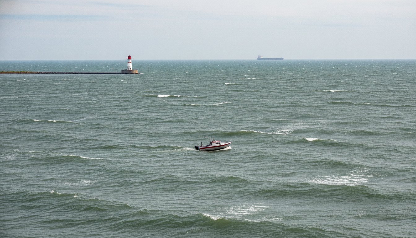
Lake Erie is the shallowest and most volatile of the Great Lakes, where a sudden shift in wind direction can transform a calm morning into a wall of whitecaps in minutes. For Southeast Michigan boaters and anglers, relying on a general weather app often leads to a wasted drive and a closed boat launch. Checking live Lake Erie webcams is the only way to see the actual state of the water before you hitch up the trailer.
Many online directories are cluttered with broken links or low-resolution feeds that fail the moment the sun goes down. You need to know if the ice is shifting at the Port of Monroe or if the swells at Sterling State Park are manageable for a small fishing boat. This guide cuts through the noise to provide reliable, working feeds from the Detroit River entrance down to the Ohio shoreline.
We have compiled the most consistent cameras for weather monitoring, vessel tracking, and checking current fishing conditions. These resources offer the visual data necessary for safe navigation and successful trips to the shore. You will find the specific links needed to monitor wave heights, track commercial shipping, and observe the state of the lake in real time.
Key Takeaways
- Verify NOAA weather reports with live visual data to avoid dangerous wave surges in the shallow western basin.
- Access the most reliable Lake Erie webcams for real-time views of Sterling State Park and the Detroit River Entrance Light.
- Master visual cues like water color and fixed pier heights to determine current fishing and ice conditions before leaving home.
- Monitor commercial vessel traffic as it moves between the Detroit River and the Michigan shoreline.
- Connect local shoreline observations to the larger Great Lakes waterway system stretching north toward the St. Clair River.
Monitoring Lake Erie: Why Live Feeds are Essential for Shoreline Safety
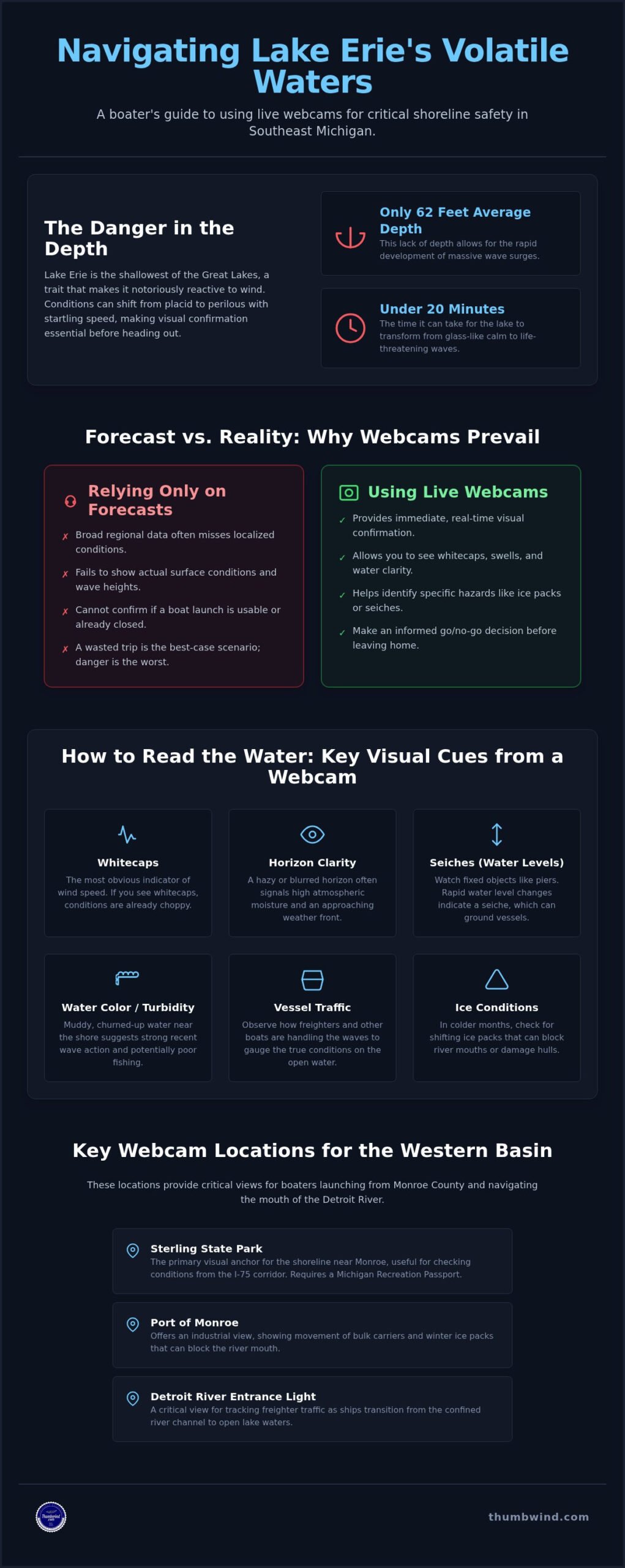
Lake Erie is the shallowest of the Great Lakes, a geographical trait that makes it notoriously dangerous for mariners. Because its average depth is only about 62 feet, the lake reacts violently to wind changes. This lack of depth allows for the rapid development of massive wave surges that can swamp a vessel in minutes. Historical records indicate the water can transition from a glass-like calm to life-threatening conditions in less than 20 minutes.
For those planning to launch from Monroe or Toledo, relying solely on a NOAA weather radio isn’t enough. Localized conditions often vary from broad regional forecasts. Checking Lake Erie webcams provides the immediate visual confirmation needed to verify if the reported wind speeds match the actual surface conditions. This real-time data is a critical safety step for anyone heading out on the water.
To see how quickly conditions can change at a major port, watch this live feed from the Ohio shoreline:

Visual feeds also help identify "seiches," which are standing waves that cause the water level to drop on one end of the lake and rise on the other. During a strong wind event, the water level at the western end can fluctuate by several feet in a short window. Seeing these shifts on a camera helps boaters avoid grounding their vessels in unexpectedly shallow harbors or boat slips.
The Role of the Western Basin in Michigan Navigation
The Western Basin acts as a primary gateway for both commercial freighters and recreational walleye hunters. Situated at the mouth of the Detroit River, this area is a natural bottleneck for vessel traffic. Understanding the names of the Great Lakes and their connecting channels helps explain why this specific basin is so reactive; it receives the massive outflow of the upper lakes while remaining the shallowest point in the system.
Visual Cues for Weather Interpretation
Experienced observers use Lake Erie webcams to hunt for specific visual cues that radar might miss. Spotting "whitecaps" on a feed allows you to estimate wind speeds even if a local weather station is offline. You can also identify lake effect snow squalls, which often form in narrow bands that standard radar might not capture accurately. Horizon clarity is another vital indicator; a hazy or blurred horizon often signals high atmospheric moisture and an approaching weather front.
Top-Rated Lake Erie Webcams: From the Detroit River to the Ohio Shore

Most online directories focus exclusively on the Ohio shoreline, leaving Michigan boaters with a blind spot in the Western Basin. To fill this gap, Thumbwind maintains a dedicated regional webcam hub that includes feeds for the Detroit River and the Michigan side of the lake. Finding reliable Lake Erie webcams on the Michigan side helps avoid the frustration of arriving at a ramp only to find the water too rough to fish.
Michigan-Specific Feeds and Monroe County Access
Sterling State Park serves as the primary visual anchor for the shoreline near Monroe. This feed is particularly useful because of its proximity to the I-75 corridor, allowing travelers to check conditions before they leave the metro Detroit area. The Port of Monroe camera offers a more industrial perspective, showing the movement of bulk carriers and winter ice packs that can block the river mouth.
If you plan to use these locations as launch points, keep logistical details in mind. Sterling State Park requires a Michigan Recreation Passport for entry, and parking lots often fill by mid-morning during peak walleye season. The Detroit River Entrance Light camera provides a critical view for tracking freighter traffic as ships transition from the confined river channel into the open waters of the lake.
Ohio Island Feeds: Lorain Light, Put-in-Bay and Kelleys Island

The island region offers a different set of visual data. Put-in-Bay Harbor cameras provide wide-angle views of South Bass Island and the steady flow of ferry traffic. Miller Ferry operates several cameras that provide real-time transit data, which is often more reliable than scheduled arrival times during heavy weather. For the best evening visibility, the Sunset Monument Cam offers a clear look at the western horizon.
Visual data from Lake Erie webcams should always be paired with scientific monitoring. The NOAA Great Lakes Environmental Research Laboratory provides the necessary data on water clarity and algal blooms to explain why the water might look a certain way on camera. Other reliable feeds include the Marblehead Lighthouse for central basin conditions and the Port Clinton City Beach for public swimming updates. To get these regional updates and history delivered to your inbox, sign up for our newsletter.

Interpreting Live Data: Using Webcams for Fishing and Ice Conditions
Using Lake Erie webcams effectively requires more than a casual glance at the screen. To accurately judge water levels, you must locate a camera with a fixed reference point, such as a specific pier, breakwall, or buoy. If you know the height of the concrete at a local harbor, you can visually estimate the surge or drop in water level during a wind event. Comparing multiple feeds along the coast allows you to track the direction a storm front or ice pack is moving in real time.
Winter Monitoring and the "Ice Bridge"
The Western Basin is famous for its "ice bridge" to the islands, but this frozen surface is rarely stable. Shifting winds can create "leads," which are dangerous cracks in the ice that can expand into open water within minutes. Webcams allow you to spot these breaks before you head out, helping to prevent gear loss or life-threatening situations. While these visual tools are invaluable, you should always cross-reference what you see on screen with official DNR ice thickness reports. A camera might show a solid white surface, but it cannot tell you if the ice is rotten or honeycombed underneath.
Walleye and Perch: Visual Scouting for Anglers
For anglers, the "color" of the water is a primary indicator of where the fish are biting. High turbidity or "muddy" water often follows a heavy blow, and finding the mud line where stained water meets clear is a proven strategy for locating active walleye. You can use the Ohio Sea Grant webcams to scout these water conditions from home, saving you a long drive and expensive fuel. With above-average walleye hatches in eight of the past eleven years, 2026 is seeing a high volume of trophy-sized fish, making visual scouting even more critical. These feeds also reveal the current crowd levels at popular boat ramps, letting you know if you’ll be facing a long wait at the docks.
If the cameras show that the lake is too churned up for a successful fishing trip, you don’t have to stay home. The same wind that ruins fishing often uncovers new finds at rock hunting beaches in Michigan. Shoreline explorers can use these live feeds to see which beaches are getting hit by the hardest waves, which often churns up fresh Petoskey stones or slag glass for those walking the coast.
Stay informed on Great Lakes conditions and local history.
Expanding the View: Connecting Lake Erie to Michigan’s Thumb Region
Monitoring Lake Erie webcams provides a necessary local view, but this basin is merely one link in a massive hydraulic chain. The water you see at Sterling State Park originated in the upper lakes, flowing through the St. Clair River and Lake St. Clair before reaching the Detroit River. For mariners and travelers planning a route north from Monroe County, understanding this flow helps predict water clarity and current strength.
The St. Clair River and Lake Huron Connection

Port Huron and Sarnia, Ontario, serve as the northern gatekeepers for this waterway. The Blue Water Bridge feeds are essential for ship watchers who want to track 1,000-foot freighters before they enter the confined river channel. Watching these feeds gives a preview of the wind and wave conditions on Lake Huron, which are often far more severe than the relatively protected Western Basin.
If you are moving beyond the Detroit area, the Michigan Upper Thumb webcams offer live views of the rugged shoreline from Lexington up to the tip of the Thumb. These feeds allow you to see the transition from the industrial setting of the lower lakes to the expansive wind farms and jagged coastal cliffs of Huron and Sanilac counties.
Lesser-Known Shoreline Spots in the Thumb
Geography enthusiasts should look for the "Lost Peninsula" in the southernmost corner of Erie, Michigan. This tract of land is a true anomaly; it belongs to Michigan but is only accessible by driving through Toledo, Ohio. The surrounding coastline is dotted with the footprints of the state’s industrial past, providing a different perspective on the Great Lakes shore.
Several Michigan ghost towns sit near former shipping ports where the coal and lumber trades once dominated the local economy. These sites offer a stark contrast to the modern, high-traffic views found on most Lake Erie webcams today. For those planning a full Great Lakes tour, these northern views provide a necessary context for the scale and history of the entire waterway system.
Plan Your Next Trip with Real-Time Shoreline Data
Lake Erie’s shallow waters demand respect and constant observation. By utilizing the most reliable Lake Erie webcams, you can verify surface conditions at Sterling State Park or track freighter traffic at the Detroit River Entrance Light from your phone. These visual tools turn a guessing game into a calculated strategy for safer boating and more productive fishing trips in the Western Basin.
Thumbwind has provided expert coverage of Michigan’s coastal geography and regional history since 2009. Our focus remains on practical, verified information that helps you navigate the unique challenges of the Great Lakes. Whether you are monitoring ice floes in the winter or scouting for walleye in the spring, having a live view of the water is an essential part of any shoreline itinerary.
Join our community of Great Lakes enthusiasts for an ad-free experience and the latest updates on Michigan’s changing shorelines. It’s the best way to stay connected to the history and the water that define our region. We look forward to seeing you out on the coast.
Frequently Asked Questions
Where are the most reliable Lake Erie webcams located?
Reliable Lake Erie webcams are typically those hosted by municipal governments or state agencies because they have the infrastructure for consistent uptime. Feeds from the Lorain Port Authority and various Ohio state parks are known for staying online during heavy storms. These cameras provide a steady stream of data for boaters who need to verify shoreline conditions. Choosing feeds with high-definition sensors ensures you can see water texture even in low-light situations.
Can I see real-time wave heights on Lake Erie webcams?
While most Lake Erie webcams do not display digital wave height data, you can estimate conditions by watching water interaction with fixed structures. Look for waves hitting breakwalls or pier heads to judge intensity. If the water is cresting over a known six-foot structure, you can safely assume conditions are hazardous. For precise measurements, cross-reference the visual feed with NOAA buoy data from the Western Basin.
Are there live cameras for monitoring Lake Erie ice coverage?
Live cameras are excellent tools for monitoring ice coverage, especially in the shallow Western Basin where ice forms and shifts rapidly. Feeds from the Detroit River mouth and the Lake Erie islands show the presence of pack ice and open leads. These visuals are vital for ice anglers and ferry operators who need to see real-time movement. Always check these feeds before attempting to travel on or near the frozen lake.
How do I find webcams for the Detroit River and Western Basin?
Finding webcams for the Detroit River and Western Basin is easiest through dedicated Great Lakes monitoring sites and regional news hubs. You should look for feeds located in Wyandotte, Grosse Ile, and near the mouth of the river at the Detroit River Entrance Light. These locations provide a comprehensive view of the shipping lanes. Many of these feeds are hosted on YouTube or municipal websites, offering a direct look at the water 24 hours a day.
Are Lake Erie webcams available for public use during the winter?
Most public Lake Erie webcams remain active throughout the winter months to assist with safety and ice monitoring. However, visibility can be limited by blowing snow, lens frost, or power outages during severe winter storms. While the feeds are available 24/7, nighttime visibility is often poor unless the camera is near a well-lit harbor or industrial port. Always verify the timestamp on the feed to ensure the image is current.
Which webcams are best for tracking Great Lakes freighters on Lake Erie?
To track Great Lakes freighters, focus on webcams located at major navigation bottlenecks like the Detroit River mouth or the Port of Lorain. These cameras show vessels as they enter or exit the confined shipping channels of the Western Basin. The Marblehead area also provides a wide-angle view of the central shipping lanes. Using these visual feeds alongside AIS tracking apps provides the most accurate picture of where a specific freighter is located at any given time.
Disclaimer
Information published on Thumbwind.com is provided for general informational purposes. While we make reasonable efforts to keep articles accurate and current, details such as prices, hours, regulations, access conditions, and other information may change without notice. Readers should verify important details with the appropriate business, agency or official source before making travel, financial or other decisions. Thumbwind.com is not responsible for the content, availability or practices of third-party websites linked from our articles.