


El Niño Forecast Favors Warmer, Drier Winter Across Michigan
Michigan could face a warmer, somewhat drier winter as a powerful El Niño shifts weather patterns across North America, according to a new federal outlook.
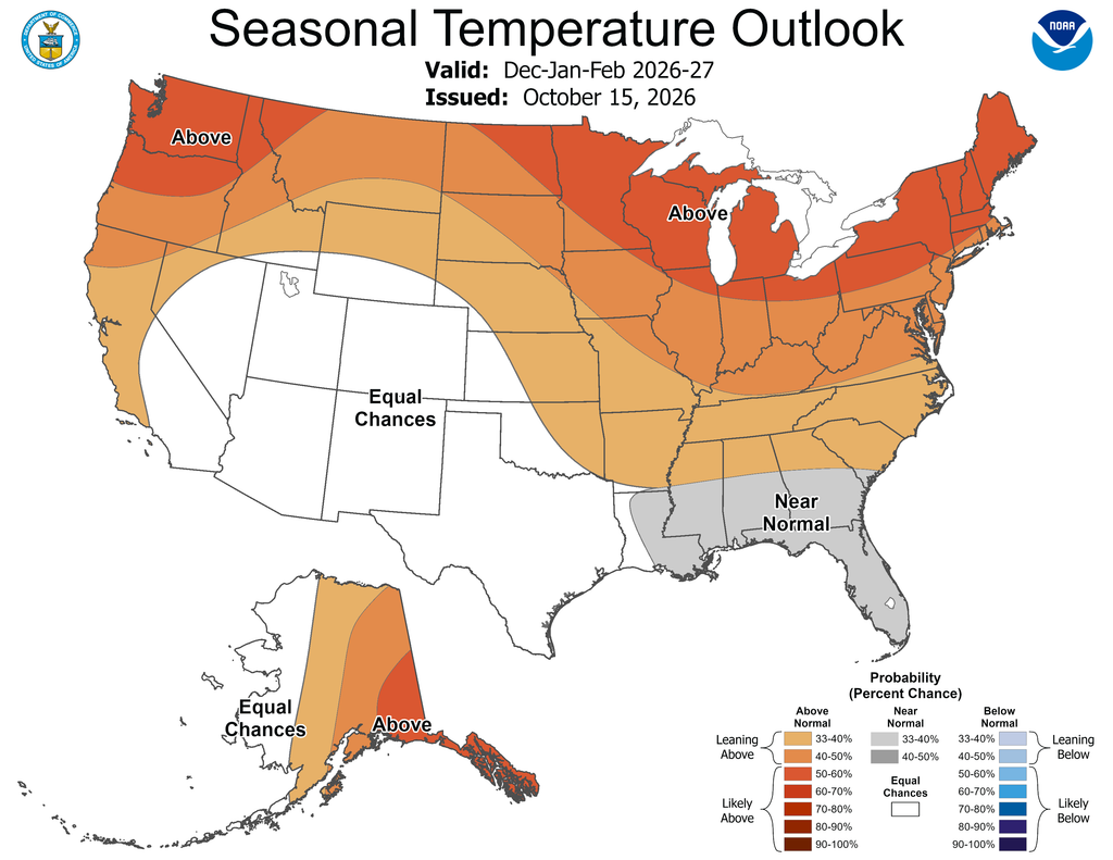
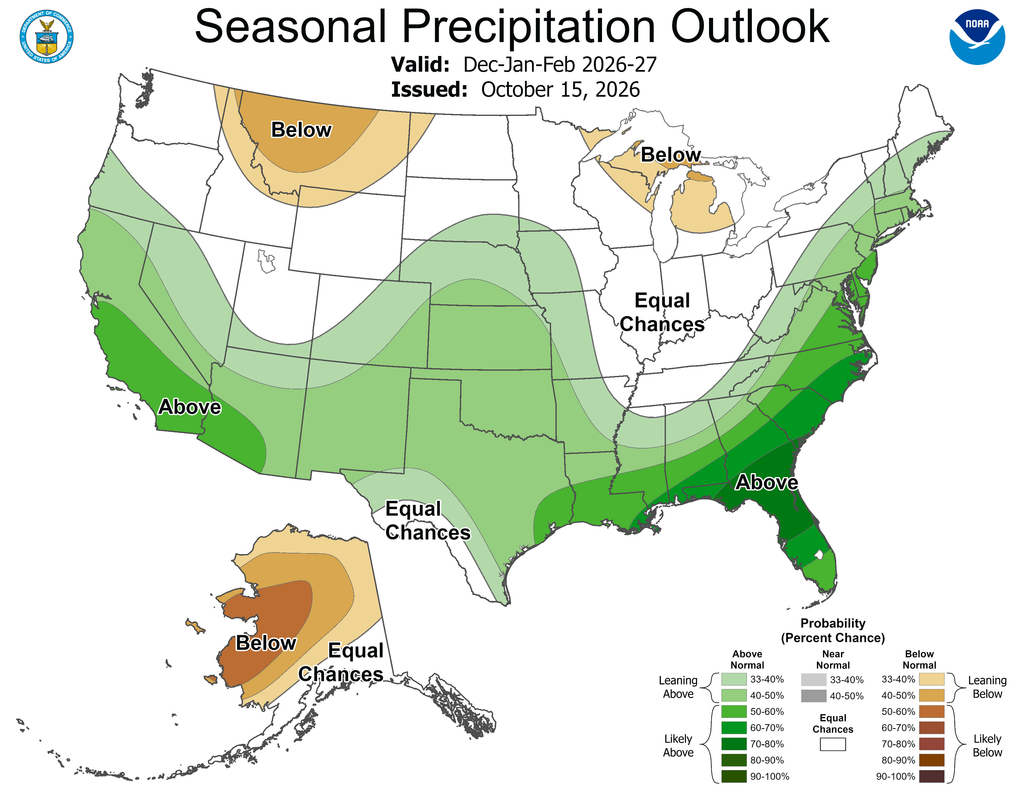
The National Oceanic and Atmospheric Administration favors above-normal temperatures across the Great Lakes from December through February. Below-normal precipitation is also more likely across parts of Michigan and the Great Lakes region.
The outlook does not mean Michigan will escape heavy snow or bitter cold. It describes the most likely pattern over three months, not the weather on any particular day.
Strong El Niño Shapes the Forecast

El Niño occurs when waters in the central and eastern tropical Pacific become unusually warm. This shift can move the jet stream and alter storm tracks across the United States.
NOAA said the current El Niño continues to strengthen. The agency expects it to last through the winter and into spring 2027.
The Climate Prediction Center reported an 83% chance the event will reach historically strong levels during October through December. A very strong El Niño is more likely to produce familiar regional effects, but it does not guarantee them.
El Niño winters often direct more storms across the southern United States. Michigan and other northern states can remain on the warmer and quieter side of that storm track.
NOAA’s Detroit office said temperatures are likely warmer than normal throughout southeastern Michigan. The precipitation outlook leans drier across much of the Lower Peninsula.
Less Snow Is Favored, Not Guaranteed
Past winters provide some support for the forecast.
About 75% to 80% of strong or very strong El Niño winters since 1950 produced above-normal temperatures in southeastern Michigan, according to the National Weather Service. Only about 25% produced above-normal snowfall.
At least part of southeastern Michigan received below-normal snowfall during every previous strong El Niño except the winter of 2009-10.
However, snowfall can vary considerably within the region. Lake-effect bands and individual storms can produce heavy accumulations even during a mild winter.
For comparison, the normal December-through-February snowfall is 37.1 inches in Saginaw and 39.5 inches in Flint. Detroit normally receives 35.4 inches during those three months.
NOAA does not issue seasonal snowfall-total forecasts because snow depends on storm tracks and temperatures that cannot be predicted months in advance reliably. A warmer seasonal average can still include several sharp cold spells and disruptive winter storms.
Great Lakes Ice Could Be Limited
A warmer winter could also reduce ice formation on the Great Lakes, although NOAA has not yet issued a final seasonal ice forecast.
Research from the U.S. Geological Survey found that three of the four recent very strong El Niño winters produced below-average maximum ice cover on every Great Lake. The winter of 1991-92 was an exception, demonstrating that other atmospheric patterns can overcome El Niño’s influence.
NOAA researchers say ice cover has declined by about 5% per decade since 1973. The average Great Lakes ice season has also shortened by approximately 27 days.
Low ice can extend commercial navigation, but it can create problems for winter recreation. It may shorten the ice-fishing season and leave shorelines exposed to winter waves.
Open water does not automatically produce more lake-effect snow. Lake-effect storms require sufficiently cold air passing across the warmer water. El Niño can reduce those cold-air outbreaks, limiting the number of opportunities for major lake-effect events.
Existing Dryness Bears Watching
Parts of Michigan enter the cold season with rainfall deficits.
From July 15 through Oct. 14, Saginaw received 6.32 inches of rain, about 3.25 inches below normal. Flint was about 1.58 inches below normal during the same period.
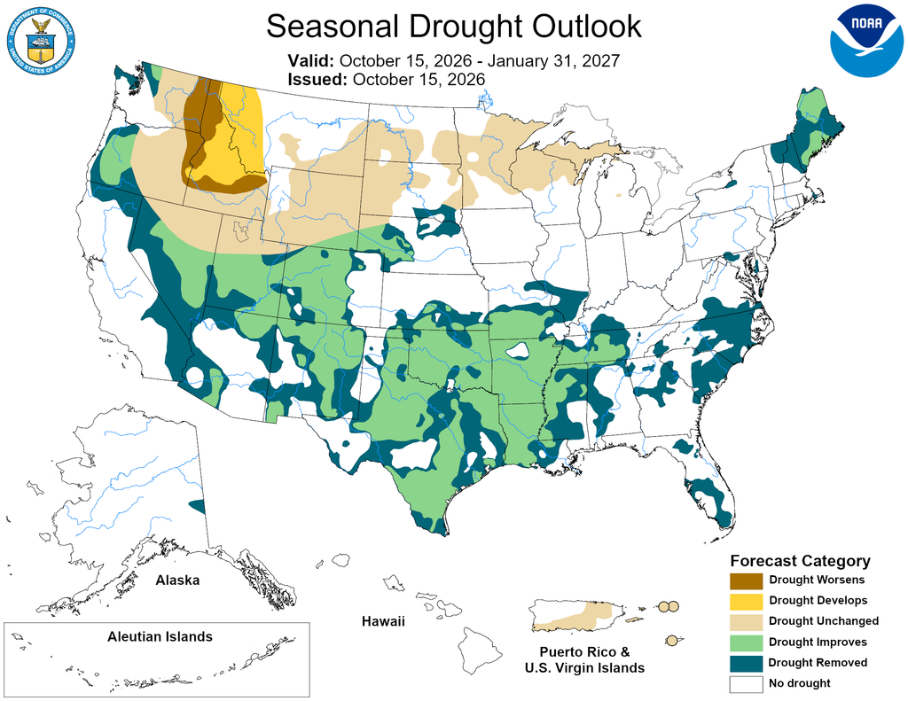
Abnormally dry conditions cover much of southeastern Michigan, while drought is more widespread in the Upper Peninsula. NOAA does not expect drought to develop or worsen across southeastern Michigan during winter, but northern drought conditions could persist.
The Climate Prediction Center will update its three-month outlook Nov. 19. Shorter-range forecasts will provide better guidance about individual cold waves and snowstorms as winter approaches.

