



Michigan Thumb Fall Color Tour: Port Austin to Caseville
While crowds swarm the Upper Peninsula in late September, the most reliable autumn foliage often waits until late October along the Lake Huron coastline. Travelers frequently find that the “peak” dates advertised by national tourism sites don’t account for the Great Lakes. The water keeps the shoreline warmer and the leaves greener for several weeks longer than inland regions like Tuscola County.
You likely want to see the vibrant maples and oaks without the gridlock of Traverse City or the spotty cell service found in more remote areas. This guide provides a practical, journalist-led itinerary for a Michigan Thumb fall color tour along the M-25 coastal route. It moves beyond the usual promotional hype to offer a realistic look at navigating the road from Port Austin to Caseville during the peak of the season.
We will provide a specific driving map with stops at historic landmarks like Port Hope and explain how the 1881 Great Fire shaped the current forest. We also use live webcam data to help you time your trip perfectly. You will get the logistical details needed to navigate Huron County, from parking at Port Crescent State Park to finding the best views of the Saginaw Bay.
Key Takeaways
- Understand how Lake Huron acts as a thermal heat sink, delaying the autumn peak along the coast by up to ten days compared to inland areas.
- Follow a specific 150 mile driving route that begins in Bay City and tracks the shoreline through the most scenic stretches of M-25.
- Find the best locations for your Michigan Thumb fall color tour, including the historic Port Hope chimney and various Huron County parks.
- Plan for logistical challenges like sparse gas stations and poor cell service by downloading navigation tools before you reach the northern tip of the county.
- Access live regional webcams to verify current foliage conditions and avoid the crowds found in other popular Michigan destinations.
Mapping the M-25 Coastal Route from Bay City to Port Sanilac
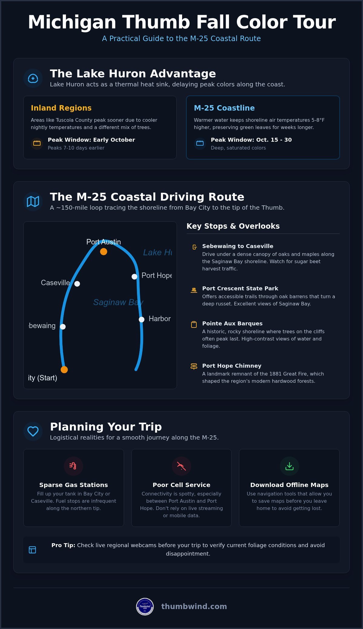
The M-25 highway route serves as the primary artery for any Michigan Thumb fall color tour, tracing the perimeter of the region’s shoreline for nearly 150 miles. While many travelers head to the U.P. or M-22 in late September, this coastal loop offers a different perspective on the season. The journey typically begins in Bay City and follows the water north through Sebewaing, Caseville, Port Austin, and Harbor Beach. If you complete the full loop and return via M-19 or M-53, you’ll cover approximately 150 miles of varying terrain.
This route isn’t just a path for viewing leaves; it’s a look at the transition from industrial ports to agricultural heartlands and quiet coastal villages. The M-25 corridor acts as the backbone for the entire region’s autumn activity. You’ll find that the drive changes character every twenty miles as the elevation and proximity to the lake shift.
To better understand the natural surroundings you’ll encounter, watch this helpful video:

The Western Shore: Sebewaing to Caseville
Driving north from Bay City, the terrain shifts from flat agricultural fields into the wooded shoreline of Saginaw Bay. October is the height of the sugar beet harvest, and you’ll share the road with trucks hauling the crop to the factory in Sebewaing. This stretch features several unique Michigan roadside attractions that provide a break from the driving. The trees here are mostly oaks and maples that benefit from the bay’s moisture, creating a dense canopy that hangs over the two-lane highway.
The Tip of the Thumb: Port Austin and Pointe Aux Barques
Port Austin sits at the very tip of the Thumb, where the waters of Saginaw Bay meet Lake Huron. The views here are expansive, often showing high-contrast blue water against the deep oranges of the shoreline. Port Crescent State Park provides accessible trails through rare oak barrens, which turn a deep russet color late in the season. For those interested in the maritime past, the Pointe Aux Barques history explains how this rocky shoreline became one of the most dangerous stretches for Great Lakes shipping. The trees along these cliffs often peak later than those just a few miles inland.
Predicting Peak Color: How Lake Huron Influences the Autumn Timeline
Lake Huron functions as a massive thermal heat sink, absorbing solar radiation throughout the summer and releasing it slowly during the autumn months. This process creates a temperate microclimate along the M-25 corridor that effectively delays the first hard frost. While inland areas of the Thumb may see leaves turning in early October, the coastal stretch remains green for much longer. This “lake effect delay” is driven by water temperatures that often hover in the low 50s through mid-October, keeping overnight air temperatures near the shore 5 to 8 degrees higher than in the interior valleys.
Because of this temperature delta, the typical peak window for a Michigan Thumb fall color tour falls between October 15 and October 30. Travelers who visit too early often find the shoreline foliage hasn’t yet transitioned, while those who wait until late October are rewarded with deep, saturated hues. Inland counties like Tuscola usually peak seven to ten days before coastal towns like Port Austin or Caseville, making it possible to see two distinct phases of autumn in a single afternoon drive.
Shoreline vs Inland: Why Ten Miles Matters
The contrast in foliage is not just about timing but also tree biology. Inland forests are dominated by maples that react quickly to shorter days, while the coastal ridges feature hardy oaks that hold their color well into November. Much of this species distribution is a direct result of the 1881 Great Fire, which swept through the region and cleared the way for hardwoods to replace the original white pine stands. To ensure your timing is accurate, you can check the live regional webcams to see real-time conditions before you leave home.
Species Spotlight: Maples, Oaks, and Poplars
The swampy lowlands near Sebewaing and Caseville are home to Red Maples, which provide the first flashes of vibrant crimson in the region. As the season progresses, Golden Poplars become the primary attraction, offering a consistent yellow glow that remains visible even on overcast days in late October. The absence of large pine groves is a reminder of the 19th-century logging era, when the region’s timber was harvested to rebuild cities like Chicago. For more updates on local history and seasonal events, consider joining our Michigan Moments newsletter for weekly insights.

Historic Stops and Shoreline Overlooks Along the Route
Huron County’s extensive park system offers some of the best vantage points for a Michigan Thumb fall color tour. Michigan Sleeper State Park stands out as a prime foliage site, where the canopy of ancient oaks and maples shades miles of hiking trails just across the road from the beach. This park contains over 700 acres of forest with designated paths that remain accessible well into the late autumn season.
If you’re planning a visit after mid-October, be aware that many shops and restaurants in Port Austin shift to limited winter hours. This seasonal transition often catches tourists by surprise, so it’s best to verify local business schedules before you arrive. While the crowds thin out, the logistical reality is that finding a hot meal on a Tuesday afternoon becomes more difficult than it is in July.
Several stops along this route offer specific amenities for autumn visitors:
- Stafford County Park: Features the historic chimney and lakeside trails in Port Hope.
- Trescott Street Pier: A 1,000-foot walkway in Harbor Beach perfect for photography.
- White Rock Park: Provides a roadside overlook with views of the famous rock formation and coastal hardwoods.
Port Hope and the 1881 Fire Legacy
The village of Port Hope serves as a silent witness to the region’s industrial era and its resilience. Its most recognizable feature is the massive brick chimney, which is all that remains of a lumber mill that once dominated the local economy. While the 1881 Great Fire leveled much of the county and destroyed thousands of homes, this structure survived the heat and now stands as a stark monument against the autumn leaves.
Stafford County Park, located adjacent to the chimney, features walking trails that lead directly to the water’s edge. These paths provide clear views of the shoreline foliage where the trees meet the rocky coast. The contrast between the weathered red bricks of the chimney and the yellow poplars creates one of the most distinctive visual markers in the Thumb.
Harbor Beach and the World’s Largest Man-Made Harbor
Further south on M-25, Harbor Beach provides an expansive look at the lake’s influence on the local geography. The city is home to the world’s largest man-made harbor, protected by a breakwall that stretches for miles into Lake Huron. This panoramic view is a highlight of any Michigan Thumb fall color tour, especially during the late October peak when the wind begins to pick up off the water.
Photographers will find the best angles at the Trescott Street Pier, where the lighthouse is often framed by the deep reds of the waterfront parks. This pier allows you to walk nearly 1,000 feet out into the water, providing a perspective of the coastline that you won’t find from the highway. The area has successfully transitioned from a gritty maritime shipping hub into a destination for kayaking and birdwatching.
Planning Your Trip: Logistics, Connectivity, and Roadside Realities
Executing a successful Michigan Thumb fall color tour requires more than just a full tank of gas. While the M-25 route offers some of the best views in the state, the northern reaches of Huron County remain largely rural and underserved by modern infrastructure. You shouldn’t rely on streaming GPS once you pass Sebewaing. Cellular service is notoriously spotty between Port Austin and Harbor Beach, making offline maps a necessity for navigation.
Gas stations are also sparse along the northern tip of the Thumb. If you’re driving the 30-mile stretch between Port Austin and Harbor Beach, ensure your tank is full before leaving either town. Public restrooms are equally limited; most seasonal county park facilities close by mid-October. Your best bets for a stop are the year-round facilities at state parks or the municipal hubs in Caseville and Harbor Beach.
Before you depart, check the local marine forecast for high-wind events. Lake Huron is prone to sudden gales in late October, which can spray lake water directly onto the roadway in sections where M-25 hugs the shore. If a gale warning is in effect, expect high winds that can make driving a high-profile vehicle like an SUV or RV difficult. Always prioritize safety over a photo opportunity during a storm surge.
The Best Driving Strategy for a One-Day Tour
To see the best of the region in a single day, start your journey in Bay City by 8:00 AM. This timing allows you to reach Caseville for an early lunch at one of the local diners near the Gillingham fishing docks in Caseville. You’ll arrive in Port Austin by early afternoon, giving you enough daylight to explore the trails at Port Crescent before the sun begins to dip.
If you’re heading back to Detroit or Flint, don’t feel obligated to take the shoreline route all the way back. Turning south on M-53 from Port Austin provides a much faster return trip through the agricultural heart of the Thumb. This inland route also passes several farm markets where you can pick up seasonal cider and apples, providing a different perspective of the harvest season.
Photography and Stargazing Opportunities
Photographers should prioritize the “golden hour” along the eastern shoreline in Sanilac County for the best morning light. However, if you’re staying late, the dark sky conditions at Port Crescent State Park are among the best in the Lower Peninsula. As a designated Dark Sky Preserve, it offers a rare chance for night photography without the interference of city light pollution. Combine your stargazing with a late afternoon stop at a local farm market to round out your Michigan Thumb fall color tour experience.
Timing Your Trip for the Final Autumn Peak
A successful Michigan Thumb fall color tour relies on patience and preparation. You’ve learned that the shoreline peaks later than the rest of the state, usually in the back half of October. By tracking the lake’s thermal influence and monitoring local conditions, you can avoid the crowded tourist traps found elsewhere in Michigan.
Remember to download your navigation tools before you lose signal in the northern stretches of Huron County. Whether you are photographing the Port Hope chimney or hiking the oak barrens of Port Crescent, having a logistical plan ensures you focus on the scenery rather than searching for a gas station. Our team provides expert historical reporting and access to live regional webcams to help you plan the perfect visit. We take pride in being a local guide to Huron and Sanilac counties.
Enjoy the quiet beauty of the season while it lasts. The Thumb remains one of the few places where you can still find a peaceful stretch of highway under a canopy of gold and red. We hope this guide helps you navigate the M-25 with confidence this October.
Frequently Asked Questions
When is the best time to see fall colors in the Michigan Thumb?
The most reliable window for a Michigan Thumb fall color tour is mid-to-late October. While the U.P. peaks in September, the lake’s thermal mass keeps the shoreline warmer for several weeks. You should wait for a series of cool nights to trigger the most vibrant reds and oranges. If you see frost in inland Tuscola County, the coastal towns will typically peak about one week later.
What is the most scenic road for a fall color tour in the Thumb?
M-25 is the definitive route for any color tour in this region. This highway follows the Lake Huron shoreline and is often referred to as the “Thumbcoast” by local travel planners. The stretch between Bay Port and Port Austin is particularly scenic because it offers higher elevation views of the Saginaw Bay. You’ll find several roadside parks along this path that allow for quick stops without leaving the main road.
Are there crowds during the Thumb fall color season?
Crowds are minimal compared to Northern Michigan, but some areas see localized activity. Caseville County Park remains open for camping until October 31, 2026, and can be busy during the Pumpkin Fest on September 19. Most of the season is quiet, making it easy to find parking at trailheads. This lack of congestion is a primary draw for travelers seeking a peaceful Michigan Thumb fall color tour.
Where can I find live updates on the foliage status in Huron County?
Access the live regional webcams at Thumbwind to see the actual tree line in Caseville or the Port Austin harbor. These feeds provide a 24/7 look at the current foliage status rather than relying on a static prediction map. Since lake conditions can change the timeline quickly, these visual checks are the most accurate way to time your trip before you leave your home.
Which state parks in the Thumb have the best hiking for fall colors?
Port Crescent State Park features the Steel Bridge Trail, which is ideal for viewing river-side maples and rare oak barrens. Sleeper State Park offers a more traditional forest canopy with deep woods that turn vibrant gold in late October. Both parks require a Michigan Recreation Passport for vehicle entry. For Michigan residents, this pass costs $20 when purchased with license plate registration during the 2026 season.
Is there reliable cell service along the M-25 coastal route?
Cell service is spotty once you leave the main towns like Caseville or Harbor Beach. Major dead zones exist near the Sanilac and Huron county line and along the rural stretches of M-25. Always keep a physical map or a downloaded Google Map in your vehicle to avoid getting lost on the backroads. This is especially important if you plan to explore the historic cemeteries or inland farm markets.
Disclaimer
Information published on Thumbwind.com is provided for general informational purposes. While we make reasonable efforts to keep articles accurate and current, details such as prices, hours, regulations, access conditions, and other information may change without notice. Readers should verify important details with the appropriate business, agency or official source before making travel, financial or other decisions. Thumbwind.com is not responsible for the content, availability or practices of third-party websites linked from our articles.